
The Krishna River is a river in the Deccan plateau and is the third-longest river in India, after the Ganges and Godavari. It is also the fourth-largest in terms of water inflows and river basin area in India, after the Ganges, Indus and Godavari. The river, also called Krishnaveni, is 1,400 kilometres (870 mi) long and its length in Maharashtra is 282 kilometres. It is a major source of irrigation in the Indian states of Maharashtra, Karnataka, Telangana and Andhra Pradesh.

Prakasamdistrict is one of the twelve districts in the coastal Andhra region of the Indian state of Andhra Pradesh. It was formed in 1970 and reorganised on 4 April 2022. The headquarters of the district is Ongole. It is located on the western shore of Bay of Bengal and is bounded by Bapatla district and Palnadu districts in the north, Nandyal district in the west, Kadapa and Nellore districts in the south. A part of north west region also borders with Nagarkurnool district of Telangana. It is the largest district in the state with an area of 14,322 km2 (5,530 sq mi) and had a population of 22,88,026 as per 2011 Census of India.

Nagarjuna Sagar Dam is a masonry dam across the Krishna River at Nagarjuna Sagar which straddles the border between Palnadu district in Andhra Pradesh and Nalgonda district in Telangana. The dam provides irrigation water to the districts of Palnadu, Guntur, Nalgonda, Prakasam, Khammam, Krishna, and parts of West Godavari. It is also a source of electricity generation for the national grid.
Markapuram is a town in Prakasam district of the Indian state of Andhra Pradesh. It is a municipality and is the headquarters of Markapuram mandal in Markapuram revenue division. Markapuram is notable for the Chennakesava Swamy Temple, built by King Sri Krishnadevaraya. During Ratha Yatra there occurs a popular carnival; the town is also famous for Chenna Kesavaswamy on the day of Rathsapthami, which is attended by thousands of people coming from different parts of the state. It is the second-largest town in Prakasam district after Ongole and it is the main place within West Prakasam district to avail all facilities.

Kammanadu is a historical region in the Indian state of Andhra Pradesh. It consisted of parts of the present day Guntur and Prakasam districts.
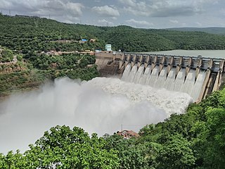
The Srisailam Dam is constructed across the Krishna River in Nandyal district, Andhra Pradesh and Nagarkurnool district, Telangana near Srisailam temple town and is the 2nd largest capacity working hydroelectric station in India.

The River Nagavali also known as Langulya is one of the main rivers of Southern Odisha and Andhra States in India, between Rushikulya and Godavari basins.
Addanki is a Municipal city in Bapatla district of the Indian State, Andhra Pradesh. Addanki North is the mandal headquarters of Addanki mandal in Addanki revenue division.

Cumbum, natively spelt as Kambham, is a census town in Prakasam district of the Indian state of Andhra Pradesh. It is the headquarters of Cumbum mandal in Markapur revenue division. It was a part of Kurnool district before it was merged into Prakasam district.

Kanigiri is a town in Prakasam district of the Indian state of Andhra Pradesh. It is a municipality and the headquarters of Kanigiri mandal in Kanigiri revenue division.

Podili is a Municipality Town in Prakasam district of the Indian state of Andhra Pradesh. It is the mandal headquarters of Podili mandal. Podili is also known as Prudulapuri. Before British rule its name was "Prudulapuri" meaning "Head quarters of the universe". There is purana reference to this related to Prudhu Chakravarthi.
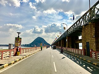
The Prakasam Barrage stretches 1223.5 m across the Krishna River connecting Vijayawada, NTR and Mangalagiri Tadepalle Municipal Corporation, Guntur districts in Andhra Pradesh, India. The barrage serves also as a road bridge and spans over a lake. The three canals associated with the barrage run through the city of Vijayawada, crossing it and giving it a Venetian appearance.

Kondaveedu Fort is a historically significant ancient hill fortress located in Kondaveedu, a village in the Chilakaluripet constituency of Palnadu district, Andhra Pradesh, India. The site is located 16 miles west of the city of Guntur. Apart from this main fort, there are two other forts nearby. Efforts are in progress to classify Kondaveedu Fort as a UNESCO World Heritage Site.

The Nallamalas are a section of the Eastern Ghats which forms the eastern boundary of Rayalaseema region of the state of Andhra Pradesh and Nagarkurnool district of the state of Telangana, in India. They run in a nearly north–south alignment, parallel to the Coromandel Coast for close to 430 km between the rivers, Krishna and Pennar. Its northern boundaries are marked by the flat Palnadu basin while in the south it merges with the Tirupati hills. An extremely old system, the hills have extensively weathered and eroded over the years. The average elevation today is about 520 m which reaches 1100 m at Bhairani Konda and 1048 m at Gundla Brahmeswara. Both of these peaks are in a north westerly direction from the town of Cumbum. There are also many other peaks above 800m.

The Polavaram Project is an under construction multi-purpose irrigation project on the Godavari River in the Eluru District and East Godavari District in Andhra Pradesh. The project has been accorded National project status by the Central Government of India. Its reservoir back water spreads up to the Dummugudem Anicut and approx 115 km on Sabari River side. Thus back water spreads into parts of Chhattisgarh and Odisha States. It gives major boost to tourism sector in Godavari Districts as the reservoir covers the famous Papikonda National Park, Polavaram hydro electric project (HEP) and National Waterway 4 are under construction on left side of the river. It is located 40 km to the upstream of Sir Arthur Cotton Barrage in Rajamahendravaram City and 25 km from Rajahmundry Airport.
The Pulichintala Project is a multi-purpose water management project for irrigation, hydropower generation, and flood control in the state of Andhra Pradesh, India. It is a crucial irrigation facility for farmers in four coastal districts: West Godavari, Krishna, Guntur, Palanadu, and Prakasam, covering over 13 lakh acres. It has 24 gates and a balancing reservoir with a capacity of 46 Tmcft at 175 feet (53 m) MSL full reservoir level (FRL).
Gundlakamma Reservoir Project is an irrigation project across the Gundlakamma river located in Prakasam district in Andhra Pradesh, India. The dam, with 3.859 billion cubic feet of live storage capacity.

Ongole cattle are an indigenous cattle breed that originates from Prakasam District in the state of Andhra Pradesh in India. The breed derives its name from the place the breed originates from, Ongole. The Ongole breed of cattle, Bos indicus, is in great demand as it is said to possess resistance to both foot and mouth disease and mad cow disease. These cattle are commonly used in bull fights in Mexico and some parts of East Africa due to their strength and aggressiveness. They also participate in traditional bull fights in Andhra Pradesh and Tamil Nadu. Cattle breeders use the fighting ability of the bulls to choose the right stock for breeding in terms of purity and strength. The mascot of the 2002 National Games of India was Veera, an Ongole Bull.
The Veligonda Project is an irrigation project located in Markapur, Prakasam district in Andhra Pradesh, India. When completed, the project will provide irrigational facilities to 447,000 acres and drinking water to 1.5 million people in 30 Mandals of fluoride and drought affected areas in Prakasam district, Nellore district and Kadapa district by diverting 43.5 TMC of floodwater from the Krishna River from foreshore of Srisailam Reservoir near Kollamvagu and proposed to store in Nallamalasagar Reservoir. The water for the project is drawn through two 18.8 km long tunnels across Nallamala hills. The project has been renamed to the "Poola Subbaiah Irrigation Project". It displaces around 20,946 families. The oustees have protested for enhanced compensation over the years and many have not received the compensation promised to them.

Kandula Obul Reddy, popularly known as Obul Reddy was an Indian politician. He held prominent roles throughout his career, serving as the General Secretary of the Congress for Madras State and later as a Cabinet Minister and as a Parliamentarian.


