Duduma Waterfall is situated in the border of Koraput (Odisha) districts of India.
Kendujhar is a town with municipality in Kendujhar District in the Indian state of Odisha. It is the administrative headquarters of the Kendujhar district, and it is one of the fifth scheduled areas of Odisha.
Anandapur is a town and municipality of Kendujhar district in the state of Odisha, India.
Barbil is a town and a Municipal Council in the Kendujhar district of the state of Odisha, India. The region around Barbil has one of the largest deposits of iron ore and manganese ore in the world. It is a major source of revenue generation for both the central and the state governments.
Karanjia is a town and a Municipality in the eastern Indian state of Odisha, about 221 kilometres (134 mi) north of the state capital Bhubaneswar. It is the sub-divisional headquarter of Panchpir sub-division and a NCA in Mayurbhanj district. It is bounded on its South-East by Deo river which forms the natural district border for Mayurbhanj.

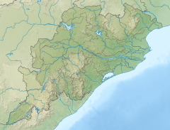
Kendujhar District, is an administrative district of Odisha. The district is one of the fifth Scheduled Areas of Odisha. The town of Kendujhar is the district headquarters. The district has three sub-divisions, Anandapur, Champua, and Kendujhar.

Odisha is one of the 28 states in the Republic of India. Odisha is located in the eastern part of the Indian peninsula and the Bay of Bengal lies to its East while Chhattisgarh shares its border in the west and north-west. The state also shares geographic boundaries with West Bengal in the north-east, Jharkhand in the north and Andhra Pradesh in the south. The state is spread over an area of 1,55,707 km2 and extends for 700 km from north to south and 500 kilometres from east to west. Its coastline is 450 km long. The state is divided into 30 districts which are further subdivided into 314 blocks called tahasil.
Tourism in Odisha is one of the main contributors to the economy of Odisha, India, with a 500 km (310 mi) long coastline, mountains, lakes, natural biodiversity and rivers. Odisha is a major tourist destination in India, with various tourist attractions, including wildlife reserves, beaches, temples, monuments, the arts and festivals. Other than wildlife reserves, beaches, temples, monuments, the arts and festivals, the Odisha Tourism Development Corporation, a public sector undertaking of the Government of Odisha, is also developing the tourism sector of Odisha and India.
Bhanda Kansara is a village in the Indian state of Odisha, with a population of more than 4,000 people located in the Kendujhar district.

The Khandadhar Falls is located in Nandapani, Bonaigarh in the Sundargarh district on the Indian state of Odisha. It is the 9th highest waterfall in India and the second highest in Odisha after Barehipani Falls in Mayurbhanj.

The Badaghagara Waterfall is a waterfall of the Kendujhar district in the Indian state of Odisha.

Khandadhar Falls is located in Kendujhar district in the Indian state of Odisha.
Patna is one of the 147 Legislative Assembly constituencies of Odisha state in India. It is in Kendujhar district" and is reserved for candidates belonging to the Scheduled Tribes. It is a segment of the Kendujhar parliamentary constituency.
Raisuan Airstrip, also known as Kendujhar Airstrip is a public airstrip located at Gopinathpur in the Kendujhar district of Odisha. Nearest airport to this airstrip is Barbil Tonto Aerodrome in Barbil, Odisha.
Barbil Tonto Airstrip is a public/private airstrip owned by the Government of Odisha and leased to the Jindal Steel and Power located at Barbil in the Kendujhar district of Odisha. The nearest airport/airstrip to this airstrip is Kendujhar Airstrip in Kendujhar, Odisha.
Turumunga is a village located in Patna Block of Kendujhar district in Odisha. The village has a population of 2164 of which 1117 are males while 1047 are females as per the Population Census 2011. The PIN Code of Turumunga is 758046.
Pipilia is a medium-size village located in Ghatgaon of Kendujhar district, Odisha with a total of 392 families residing. The Pipilia village has population of 1,764, of which 888 are males while 876 are females as per Population Census 2011. Asanabani, Bankapatuli, Chikinia and Mundatangara are the nearby villages to Pipilia.
Purusottampur, is a village in the taluk of Champua, district of Kendujhar, in the Indian state of Odisha. The total geographical area of village is 160 hectares.
Kendujhar Sadar is an administrative unit in the Kendujhar district in the state of Odisha, India. This subdivision consists of the town Keundujhar, the administrative headquarters of the eponymous district.
Sitabinji railway station is a railway station on the East Coast Railway network in the state of Odisha, India. It serves Sitabinji village. Its code is STBJ. It has two platforms. Passenger, MEMU, Express trains halt at Sitabinji railway station.