
The Devi River is one of the principal distributaries of the Mahanadi River. It flows through Jagatsinghpur district and Puri district across Odisha state in India and joins the Bay of Bengal.
The Devi River is one of the principal distributaries of the Mahanadi River. It flows through Jagatsinghpur district and Puri district across Odisha state in India and joins the Bay of Bengal.
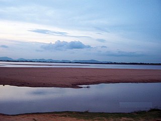
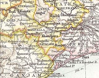
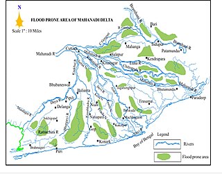
The river forms the final part of a great network of Mahanadi river. Kathajodi river is the main southern distributary of Mahanadi river branching off at Cuttack, Odisha. [1] Kathajodi river later acquires the name Devi as it flows further east. The river flows through Alipingal, Macchagaon and Naugaon blocks in Jagatsinghpur district and Astaranga and Kakatpur blocks in Puri district. [2] It reaches Bay of Bengal 70 kilometres (43 mi) south of the mouth of Mahanadhi river, a short distance from the border of Cuttack and Puri districts. [3] The mouth of the river is surrounded by dense forests absent of inhabitants. [4]
The river is navigable till Machhagaon by small sloops. It is one of the best tidal channels in Orissa; however, vessels can not enter the river upstream due to a large sediment of sand in the mouth of the river. [5] Two fishermen were killed and two injured when a boat capsized near Astarang in the Devi River on 13 May 1988. [6]
The mouth of the Devi River serves as a nesting ground for olive ridley sea turtles during their breeding season. The first rookery in this area north of Puri was discovered in 1981. Nesting occurs on mainland India and dynamic sand bars which appear and change forms from year to year. [7] About 800,000 turtles come to the region every winter for breeding. However, turtle nesting has declined in recent years due to mass death believed to be brought about by increased mechanised fishing. Over 6,000 olive ridleys were killed in 2003 alone. According to a 2007 estimate, over 130,000 turtles have been found dead on the beaches over the previous 13 years. [8] [9] The effort to set aside the mouth of Devi River and Rushikulya River as sanctuaries for olive ridley turtles was opposed by local fishing communities. [10]
Devi Kandal island people are affected by the pollution of the Devi and Kandal rivers due to the surge of huge amounts of untreated drain water from Cuttack municipality region. Both rivers are distributaries of Kathajodi River, getting significantly less water supply due to the obstruction of a concrete wall built on the mouth or initial points of both the rivers at Naraj. It was built to reserve more water for industrial buildings.[ citation needed ]
The lower amounts of water flow, largely polluted by drain water from Cuttack City, makes the water of both the rivers hazardous. As a result, there has been a drastic reduction in many species of fishes and other aquatic animals in the rivers. The fishing community has been the most affected: residents who use the water for bathing, washing clothes and agriculture purposes are impacted by various waterborne diseases and other health problems. The ground water level in the region drastically goes down in the summer as it depends upon the level and quantity of water in the rivers.[ citation needed ]

Odisha, formerly Orissa, is an Indian state located in Eastern India. It is the eighth-largest state by area, and the eleventh-largest by population, with over 41 million inhabitants. The state also has the third-largest population of Scheduled Tribes in India. It neighbours the states of Jharkhand and West Bengal to the north, Chhattisgarh to the west, and Andhra Pradesh to the south. Odisha has a coastline of 485 kilometres (301 mi) along the Bay of Bengal in the Indian Ocean. The region is also known as Utkaḷa and is mentioned by this name in India's national anthem, Jana Gana Mana. The language of Odisha is Odia, which is one of the Classical languages of India.

The Mahanadi River is a major river in East Central India. It drains an area of around 132,100 square kilometres (51,000 sq mi) and has a total length of 900 kilometres (560 mi). Mahanadi is also known for the Hirakud Dam which was the first major multipurpose river valley project after India's independence in 1947. The river flows through the states of Chhattisgarh and Odisha, before finally ending in the Bay of Bengal.

Cuttack, is the former capital and the largest city in the Indian state of Odisha. It is the headquarters of the Cuttack district. The name of the city is an anglicised form of the Odia and Sanskrit name Kataka which literally means The Fort, a reference to the ancient Barabati Fort around which the city initially developed. Cuttack is known as the Millennium City as well as the Silver City due to its history of 1000 years and famous silver filigree works. The Orissa High Court is located there and the city is judiciary capital of Odisha. It is the commercial capital of Odisha which hosts many trading and business houses in and around the city. Cuttack is famous for its Durga Puja which is one of the most important festivals of Odisha. Being the favourite destination of poets and artists, it is also the cultural capital of Odisha. Due to its beauty, the term Kataka Nagara Dhabala Tagara is coined for it. The city is categorised as a Tier-II city as per the ranking system used by Government of India.

The Brahmani is a major seasonal river in the Odisha state of eastern India. The Brahmani is formed by the confluence of the Sankh and South Koel rivers, and flows through the districts of Sundargarh, Deogarh, Angul, Dhenkanal, Cuttack, Jajapur and Kendrapara. Also South Koel can be considered as upper reaches of Brahmani. Together with the river Baitarani, Brahmani forms a large delta before emptying into the Bay of Bengal at Dhamra. It is the second widest river in Odisha after Mahanadi.

Cuttack district is one of the 30 districts of Odisha state in India. It is located in the coastal part of the state and its administrative headquarters are located in the city of Cuttack. As of 2011 Census, after Ganjam, it is the second most populous district of Odisha, with a population of 2,624,470. The name is an anglicized form of Kataka or Katak meaning Fort – referring to the Barabati Fort. The district is bisected by the river Mahanadi and its numerous distributaries and occupies a large portion of the river's delta. It is bounded by the Angul, Dhenkanal, Nayagarh and Khurda districts to the west while its southern and eastern boundaries touch Puri, Jagatsinghpur, Kendrapara and Jajpur districts.

Jagatsinghpur District is one of the thirty districts of Odisha in the eastern coast of India. It became a new district on 1 April 1993 being separated from Cuttack district with its own headquarter in Jagatsinghpur town. Deltaic and partly littoral; the district of Jagatsinghpur is triangular in shape and small in geographical proportions. It is the smallest district in the state and covers a landmass of 1759 km2. It has a history of its own dating back to the 6th century AD, having contemporaneity with the Prachi valley civilization. Its archaeological remains, navigation network, inland and overseas trade, fabric manufacturing & designing, religious tolerance and epoch-making glorious role in freedom struggle; have a savor of distinctiveness.

Puri district is a coastal district of the Odisha state of India. It has one sub-division, 11 tahasils and 11 blocks and comprises 1722 revenue villages. Puri is the only municipality of the district. Konark, Pipili, Satyabadi, Gop, Kakatpur and Nimapada are the NACs in this district while Brahmagiri being a semi-urban town.
Gahirmatha Beach is a beach in Kendrapara district of the Indian state of Odisha. The beach separates the Bhitarkanika Mangroves from the Bay of Bengal and is the world's most important nesting beach for olive ridley sea turtles. The beach is part of Gahirmatha Marine Wildlife Sanctuary, which also includes the adjacent portion of the Bay of Bengal.

Kushabhadra River forms the complex of river systems which form the distributaries of the Mahanadi River. It branches off from the Kuakhai River, which is a distributary of the Mahanadi, at Balianta and flows in a south western direction towards Nimapara and Gop for 46–50 miles before sinking into the Bay of Bengal near Ramachandi Temple, 15 miles east of Puri in the Puri District of Odisha.

The Rushikulya River is one of the major rivers in the state of Odisha and covers entire catchment area in the districts of Kandhamal and Ganjam of Odisha. The Rushikulya originates at an elevation of about 1000 metres from Rushimala Hills part of Daringbadi hills of the Eastern Ghats range. The place from where the river originates, Daringbadi is called the ' Kashmir of Odisha '. The river lies within the geographical coordinates of 19.07 to 20.19 north latitude and 84.01 to 85.06 east longitude. It meets the Bay of Bengal at Puruna Bandha in Ganjam. Its tributaries are the Baghua, the Dhanei, the Badanadi etc. It has no delta as such at its mouth.

Odisha is one of the 28 states in the Republic of India. Odisha is located in the eastern part of the Indian peninsula and the Bay of Bengal lies to its East while Chhattisgarh shares its border in the west and north-west. The state also shares geographic boundaries with West Bengal in the north-east, Jharkhand in the north and Andhra Pradesh in the south. The state is spread over an area of 1,55,707 km2 and extends for 700 km from north to south and 500 kilometres from east to west. Its coastline is 450 km long. The state is divided into 30 districts which are further subdivided into 314 blocks called tahasil.
Harishpur or Harishapur is a community in the Jagatsinghpur district of the Indian state of Odisha. The Gada Harishpur Panchayat is the location of the Sarabanta Jagatnath temple situated near by the Bay of Bengal. Most of the people here are dependent on the Bay of Bengal for their food and clothing.
Kathajodi River is an arm of the Mahanadi River in Odisha, India. It branches off at Naraj, then immediately is bifurcated. The southern branch, known as Kuakhai, which means Crow's pool, and flows into the Puri district. Its mouth is closed by a bar, so that little water flows into it except at flood times.
Dhamara is a joint stream in Odisha that is formed by the confluence of the Brahmani and Baitarani rivers south of the town of Chandabali. It lies in the Bhadrak district and empties into the Bay of Bengal. To the north of its mouth is the Dhamra Port and near the mouth is the Gahiramatha sanctuary, a nesting site for olive ridley sea turtles.
Kamashasan is one of the village in the district of Jagatsinghpur, Odisha, India. Bagula is famous for the vegetable cultivation and its quality and varieties of vegetables in major cities Odisha.
Kuakhai River is a distributary of Mahanadi River which flows by Bhubaneswar, Odisha. Mahanadi River branches off at Naraj, Cuttack as Kathajodi River, then immediately it is bifurcated, with its southern branch flowing as Kuakhai River. The Kushabhadra River branches off from the Kuakhai River Gandarpur, Balianta and flows in a south-western direction towards Nimapara and Gop into Bay of Bengal. The Daya River starts as a branch of the Kuakhai River at Saradeipur and is then joined by the Malaguni River below Golabai and flows through Khordha and Puri districts before emptying into the north-eastern corner of Chilika Lake. Most of the water supply of Bhubaneswar is met by the Kuakhai river, along with Daya River.
Kujang is a large village in Odisha, India. It is known as the gateway to the Paradip industrial area. The literacy rate of Kujang is around 90.48%, which is above the national average of 74.04%. Correspondingly, the "Bana Bihari High School", a prominent local school which was founded in 1901, is located in Kujang.
Banki or Bānki State was a princely state in Odisha during the British Raj. Its capital was Banki, in the western part of present day Cuttack district.
The 2022 Odisha floods were a series of floods in Odisha, which lasted from 14 August 2022 to 7 September 2022.

The Birupa River is a river which flows through the Indian states of Chhattisgarh and Odisha. It is a distributary of the Mahanadi River. It originates from the Mahanadi's upper reaches and joins the Brahmani River at Krushnanagar before emptying into the Bay of Bengal at Dhamra. It is one of several distributaries of the Mahanadi, including the Paika, Chitroptala, Genguti, and Lun rivers.