Related Research Articles

The Mahanadi River is a major river in East Central India. It is the longest earthen dam in the world. It drains an area of around 132,100 square kilometres (51,000 sq mi) and has a total length of 900 kilometres (560 mi). Mahanadi is also known for the Hirakud Dam which was the first major multipurpose river valley project after India's independence in 1947. The river flows through the states of Chhattisgarh and Odisha and before finally ending in the Bay of Bengal.

The Brahmani is a major seasonal river in the Odisha state of eastern India. The Brahmani is formed by the confluence of the Sankh and South Koel rivers, and flows through the districts of Sundargarh, Deogarh, Angul, Dhenkanal, Cuttack, Jajapur and Kendrapara. Also South Koel can be considered as upper reaches of Brahmani. Together with the river Baitarani, Brahmani forms a large delta before emptying into the Bay of Bengal at Dhamra. It is the second widest river in Odisha after Mahanadi.
The Utkal Plain is part of the East Coastal Plain of India. It is a coastal plain in the Odisha state of eastern India. It includes the delta of the Mahanadi River, Brahmani River, Baitarani River. The most prominent physiographic feature of this plain is the Chilka Lake. It is the biggest lake in the country and its area varies between 780 sq km in winter to 1,144 sq km in the monsoon months.
Banki is a town and a Subdivision, Legislative Council constituency no. 88 and Notified Area Council in Cuttack district in the state of Odisha, India. Banki is famous for the Charchika Temple, dedicated to the deity of Chamunda, the eight armed goddess and incarnation of Durga and for its scenic beauty. Current MLA Devi Ranjan Tripathy

Uttar Bastar Kanker District is located in the southern region of the state of Chhattisgarh, India within the latitudes 20.6-20.24 and longitudes 80.48-81.48. The total area of the district is 6432 square kilometers. The population is 748,941.

Dhamtari is a district of the Indian state of Chhattisgarh. This district is situated at 20°42' N latitude and 81°33' E longitude. Dhamtari district was officially formed on 6 July 1998 by trifurcating Raipur district into Raipur, Dhamtari and Mahasamund districts.

Chhattisgarh Division was an administrative division of the Central Provinces of British India. It was located in the east of the Central Provinces and encompassed the upper Mahanadi River basin, in the central part of present-day Chhattisgarh state of India.

Rajim Kumbh is an annual Hindu pilgrimage held in Rajim, located in Gariyaband district, Chhattisgarh, India. The pilgrimage is similar to the traditional pilgrim fairs like those held in Haridwar and Allahabad. Like them, it's a kumbh, where devotees flock in to bathe en masse in sacred rivers to wash off their sins and attain redemption.
The Tel river flows in Nabarangpur, Kalahandi, Balangir, Boudh Sonepur District of Odisha, India. Tel is an important tributary of Mahanadi. It flows just eight kilometers away from the town of Titilagarh. This significant tributary of the Mahanadi river meets the main river at Sonepur or Subarnapur. The convergence of the two rivers offers a remarkable view against a colorful landscape. Baidyanath temple, which is famous for the Kosaleshwar Shiva temple, is located on the left bank of the Tel River.

Odisha is one of the 28 states in the Republic of India. Odisha is located in the eastern part of the Indian peninsula and the Bay of Bengal lies to its East while Chhattisgarh shares its border in the west and north-west. The state also shares geographic boundaries with West Bengal in the north-east, Jharkhand in the north and Andhra Pradesh in the south. The state is spread over an area of 1,55,707 km2 and extends for 700 km from north to south and 500 kilometres from east to west. Its coastline is 450 km long. The state is divided into 30 districts which are further subdivided into 314 blocks.

Hasdeo River is the largest tributary of Mahanadi River. The river flows in the state of Chhattisgarh. It joins Mahanadi River near Shiladehi (Birra). Hasdeo Bango Dam is constructed across this river. The river originates about 910.0 m above sea level, in a place about 10.0 km from Sonhat in Koriya district. The total length of the river is 333.0 km, and drainage area is 9856 km2. The major tributary of Hasdeo River is Gej River. The river flows through the Hasdeo Arand forest.
Jonk River is a tributary of Mahanadi River that flows for approximately 210 kilometers through the Nuapada District and Bargarh District in the state of Odisha; and the Mahasamund District and Raipur District in the state of Chhattisgarh in India. The river starts from the Sunabeda plateau and enters Maraguda valley where it is joined by a stream called Gaidhas-nala near Patora village. The river forms Beniadhas fall and Kharaldhas Fall before entering the valley. It joins Mahanadi at Shivrinarayan.

Shivnath River is the longest tributary of theMahanadi River, which joins Changori in the Janjgir-Champa district in Chhattisgarh, India. It has a total course of 290 kilometres (180 mi). The name comes from the god Shiva in Hinduism.

Sondur Dam is located in Dhamtari District of Chhattisgarh in India. It was constructed in 1988 across Sondur River. The catchment area of the Sondur river up to the dam is 518 km2.
Pairi River is one of the important tributaries of Mahanadi. The river originates from the Bhatigarh hills located near Bindranavagarh of Gariaband District and it joins the Mahanadi near Rajim, Gariaband district in Chhattisgarh, India. Length of River is 90 km.
The Mand River is a tributary of the Mahanadi in India. It joins the Mahanadi in Chandarpur, in Chhattisgarh, 28 km from the Odisha border and before the river reaches the Hirakud Dam.

Ib river is tributary of Mahanadi river in North-Eastern Central India. It joins Mahanadi river flowing directly into the Hirakud Reservoir. The river originates in hills near Pandrapet at an elevation of 762 metres (2,500 ft). It passes through Raigarh district and Jashpur district of Chhattisgarh and Jharsuguda and Sundargarh District of Odisha and finally meets Mahanadi at Hirakud Dam in the state.
Surubalijora or Surubalijore is a small river located in the Subalaya area of Birmaharajpur subdivision of Subarnapur district of Odisha, India. It is originating from a mountain and merging with Mahanadi river near Subalaya, Tebhapadar and Ambasarabhata. It had created a small delta at the meeting place. Near this delta, the land is fertile and farmers from nearby villages cultivate various vegetables.

Sri Nilamadhava Temple is very old and famous Lord Vishnu temple which is near to the bank of Mahanadi, in Kantilo, Odisha, India. It is present near to the twin hills with a surrounding forest. A permanent flow of holy water from the feet of Lord Nilamadhava is another attraction of the spot. Lord Siddheswar is also present which is another highlight of the place.
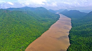
Satkosia Gorge is a gorge in eastern Odisha, India, carved by the Mahanadi River. The gorge is located within the Satkosia Tiger Reserve which is a United nations Protected area. It is also a Ramsar site designated in 2021.
References
Coordinates: 20°40′N82°01′E / 20.667°N 82.017°E