Geography
Climate
| Ranchi |
|---|
| Climate chart (explanation) |
|---|
J | F | M | A | M | J | J | A | S | O | N | D | | | | | | | | | | | | | | █ Average max. and min. temperatures in °C | | █ Precipitation totals in mm | | Source: IMD |
|
| Imperial conversion |
|---|
| J | F | M | A | M | J | J | A | S | O | N | D | | | | | | | | | | | | | | █ Average max. and min. temperatures in °F | | █ Precipitation totals in inches |
|
Ranchi [2] has a humid subtropical climate. However, due to its position and the forests around the city, it is known for its pleasant climate. Its climate is the primary reason why Ranchi was once the summer capital of the undivided State of Bihar. Ranchi used to be a preferable hill station in the past. Temperature ranges from maximum 42 to 20 °C during summer, and from 25 to 0 °C during winter. December and January are the coolest months with temperature getting to freezing point in some places of the city. The annual rainfall is about 1430 mm (56.34 inches). From June to September the rainfall is about 1,100 mm. Ranchi is located at 23°21′N 85°20′E.[5] The total area covered by the Ranchi municipal area is 175.12 square kilometres and the average elevation of the city is 651 m above sea level.
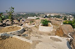
Ranchi is located on the southern part of the Chota Nagpur plateau which forms the eastern edge of the Deccan plateau. Ranchi is referred to as the "City of Waterfalls", due to the presence of numerous large and small falls of around the close vicinity of the city. The most popular ones are Dassam Falls, [7] Hundru Falls, Jonha Falls, and Panchghagh Falls.
The Subarnarekha river and its tributaries constitute the local river system. Dams in Kanke, Rukka and Hatia have been built over these channels to cater to the water requirements of majority the population.
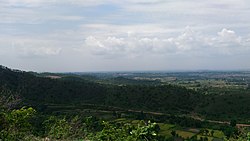
Ranchi has a hilly topography and its combination with dense tropical forests ensures that it enjoys a comparatively moderate climate compared to the rest of the state. Previously, it was accorded a 'hill station' status during the British rule. Rapid population growth and industrialization have caused considerable change in the weather pattern and rise in average temperatures. This has resulted in gradual loss of this "Hill Station" like status. It also has numerous dams constructed in different regions of the city inside and on the outskirts.
Divisions
Presently, Ranchi district is divided into 2 sub-divisions and 14 administrative blocks. On 12 September 2007, Khunti district was created by carving Khunti subdivision and its 6 blocks out of Ranchi district. Ranchi sub-division is further divided into 11 blocks: Angara, Burmu, Bero, Chanho, Kanke, Lapung, Mandar, Namkum, Ormanjhi, Ratu and Silli. Bundu sub-division comprises 3 blocks: Bundu, Sonahatu, and Tamar, The district has 7 Assembly constituencies, namely, Tamar (ST), Silli, Khijri (ST), Ranchi, Hatia, Kanke (SC), and Mandar (ST). Silli, Khijri, Ranchi, Hatia and Kanke are part of Ranchi Lok Sabha constituency.
Demographics
Historical population| Year | | |
|---|
| 1901 | 477,249 | — |
|---|
| 1911 | 557,488 | +16.8% |
|---|
| 1921 | 536,346 | −3.8% |
|---|
| 1931 | 629,863 | +17.4% |
|---|
| 1941 | 673,376 | +6.9% |
|---|
| 1951 | 748,050 | +11.1% |
|---|
| | Year | | |
|---|
| 1961 | 894,921 | +19.6% |
|---|
| 1971 | 1,164,661 | +30.1% |
|---|
| 1981 | 1,489,303 | +27.9% |
|---|
| 1991 | 1,827,718 | +22.7% |
|---|
| 2001 | 2,350,245 | +28.6% |
|---|
| 2011 | 2,914,253 | +24.0% |
|---|
|
| Source: Census of India [8] |
According to the 2011 census Ranchi district has a population of 2,914,253, [1] roughly equal to the nation of Jamaica [10] or the US state of Arkansas. [11] This gives it a ranking of 130th in India (out of a total of 640). [1] The district has a population density of 572 inhabitants per square kilometre (1,480/sq mi). [1] Its population growth rate over the decade 2001-2011 was 23.9%. [1] Ranchi has a sex ratio of 950 females for every 1000 males, [1] and a literacy rate of 76.06%. 43.14% of the population lives in urban areas. Scheduled Castes and Scheduled Tribes collectively account for 41.01% (SC 5.25% and ST 35.76%) [1] of the district's total population. The prominent scheduled communities are Oraon (18.2%), Munda (10.3%), Lohra (2.46%), Bedia (1.32%), Ghasi (1.21%), Mahli (1.09%), Dhobi (0.73%), Bhogta (0.7%), Chamar/Mochi (0.63%), Dusadh (0.36%), Pan (0.33%), Karmali (0.32%), Chik Baraik (0.32%), Dom (0.29%), Kharia (0.27%), Bhuiya (0.2%), Santal (0.19%), Turi (0.12%), Rajwar (0.11%), Gorait (0.1%), Hari/Mehtar/Bhangi (0.08%), Ho (0.07%), Binjhia (0.07%), Pasi (0.07%), and Kharwar (0.05%). Other communities such as Gond, Birhor, Bauri, Kol, Kora, Chero, Bhumij, Kisan, Nat, Mal Paharia, Musahar, Banjara, and Asur/Agaria also have populations ranging between one thousand to a hundred. [12]
This page is based on this
Wikipedia article Text is available under the
CC BY-SA 4.0 license; additional terms may apply.
Images, videos and audio are available under their respective licenses.