| Indrapuri Barrage | |
|---|---|
 | |
| Location | Rohtas District, Bihar, India |
| Coordinates | 24°50′13″N84°08′04″E / 24.8369°N 84.1344°E |
| Opening date | 1968 |
| Dam and spillways | |
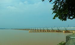
| Impounds | Son River |
| Length | 1,407 metres (4,616 ft) |
Indrapuri Barrage (also known as the Sone Barrage) is across the Son River in Rohtas district in the Indian state of Bihar.
Contents