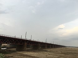
Nehru Setu | |
---|---|
Coordinates | 24°53′33″N84°12′58″E / 24.8925°N 84.2162°E |
Carries | Grand Chord railway track |
Crosses | Son River |
Locale | Dehri-Son Nagar |
Characteristics | |
Design | Steel girders on stone pillars |
Material | Stone & Steel |
Total length | 3,059 metres (10,036 ft) |
Longest span | 32.5 metres (107 ft) |
No. of spans | 93 |
History | |
Opened | 27 February 1900 |
Location | |
Nehru Setu is a railway bridge across the Son River, connecting Dehri-on-Son and Son Nagar, in Bihar.
Sir John Houlton, the veteran British administrator, who spent many years in the state, describes the Son as follows, "After passing the steep escarpments of the Kaimur range, it flows straight across the plain to the Ganges. For much of this distance it is over two miles – and at one point, opposite Tilothu – three miles wide. In the dry weather there is vast expanse of sand, with a stream not more than a hundred yards wide, and the hot west winds pile up the sand on the east bank, making natural embankments. After heavy rain in the hills even this wide bed cannot carry the waters of the Son and disastrous floods in Shahabad, Gaya, and Patna are not uncommon". [1]
When the railway line between Kolkata and Delhi was first laid, it passed through Bhagalpur, Lakhisarai, Patna and Mughalsarai, covering a distance of 1,636 km. Subsequently, the Grand Chord line via Gaya reduced the distance by 80 km. [2] The main line crosses the Son over the Koilwar bridge and the Dehri-Son Nagar bridge accommodates the Grand Chord line. [1]
Steel girders resting on 93 stone pillars, each a hundred feet apart, form the rail bridge. The total length of the bridge over abutments is 3,064 metres (10,052 ft). [3] It was opened for traffic on 27 February 1900. [4] When it was built, it was the longest bridge in India and was believed to be the second longest bridge in the world. [3] [1] Subsequently, longer road bridges were built but it remained the longest rail bridge for many years. [5] [4] The opening of the 4.62 km Vembanad Rail Bridge, connecting the Container Transshipment Terminal on Vallarpadam Island to Edappally, in February 2011, pushed it to the second position. [6]
Jawahar Setu, the road bridge carrying NH 2 and running parallel to the Nehru Setu, was constructed in 1963–65. [7]
The Government of Bihar sanctioned in 2008, a bridge across the Son River connecting Arwal and Sahar in Bhojpur district. [8]
The Koilwar bridge preceded the Nehru Setu and was opened in 1862. [9] A four-lane road bridge, carrying NH 30, parallel to the existing rail and road Koilwar Bridge, has been planned. [10]
An anicut was constructed across the Son, a little upstream of the present Nehru Setu and Jawahar Setu, in 1873–74. The Indrapuri Barrage was constructed, 8 km upstream, and commissioned in 1968. [11] Its distance from Aurangabad is approximately 15 km and 10 km from Dehri On Sone.
Son River is a perennial river located in central India. It originates near Amarkantak Hill in Gaurela-Pendra-Marwahi district of Chhattisgarh and finally merges with the Ganges River near Patna in Bihar. The Sone River is the second-largest southern tributary of the Ganges after the Yamuna River. India's oldest river bridge Koilwar Bridge over Sone River connects Arrah with Patna. Sone river is famous for its sand across country. Multiple dam(s) and hydro-electric projects run on its course towards Ganges.
The East Central Railway is one of the 19 railway zones in India. It is headquartered at Hajipur and comprises Sonpur, Samastipur, Danapur, Pt. Deen Dayal Upadhyaya, and Dhanbad divisions.
Arwal district is one of the thirty-eight districts of Bihar state, India, and Arwal town is the administrative headquarters of this district. It was earlier part of Jehanabad district.
Daudnagar is a town and the subdivisional headquarter of Daudnagar Subdivision in Aurangabad district in the state of Bihar, India under the Magadh division. Until 1991, there was only one Subdivision in the Aurangabad district: Aurangabad Sadar. On 31 March 1991, one other subdivision, Daudnagar, was created. Daudnagar is a 200-year-old historical city and its living proof is Daudnagar has an old historical fort situated on the eastern bank of the Son River. National Highway NH139 which connects Jharkhand's Palamu district to Patna, passes through the town.
Dehri also known as Dehri-on-Sone is a Nagar parishad and corresponding community development block in Rohtas district in the state of Bihar, India. Situated on the Son River, Dehri is a large industrial town and a railway hub.
Indrapuri Barrage is across the Son River in Rohtas district in the Indian state of Bihar.
Arwal town is the administrative headquarters of Arwal district in Bihar state of India. It was earlier part of Jehanabad district. The district as formed to control the naxalism in the area. District was formed from the area of two near by districts i.e. Jehanabad and Aurangabad. Arwal has a population of 588,000. Arwal, the district headquarters is approximately 80 km south from the state capital Patna. Arwal town is situated on the right side bank of the Sone River, which is a tributary to the Ganges.
Koilwar Bridge, at Koilwar in Bhojpur spans the Sone river. This 1.44 km long, 2-lane wide rail-cum-road bridge connects Arrah with Patna, the capital of Bihar state in India. The bridge is named after Indian academic and social reformer Prof. Abdul Bari, and is presently the oldest operational railway bridge in India standing since 04 November 1862. It is shown in the 1982 Oscar award winning film Gandhi, directed by Richard Attenborough. From 1862 to 1900, Koilwar bridge remained as the longest river bridge in India.
Jawahar Setu is across the Son River, between Dehri-on-Son and Son Nagar, in the Indian state of Bihar. It is named after the first prime minister of India, Jawaharlal Nehru. It was designed and completed in 1963 by principal engineer Shantaram S. Kashyap.
Rajendra Setu, or Simaria Bridge, is a bridge across the Ganges that was the first to link the northern and southern portions of the state of Bihar. The location of the bridge was based on the work of M. Visvesvaraya, who was more than 90 years old at the time. In a wheelchair, he visited the bridge site on the special request of Bihar's chief minister, Shri Krishna Sinha. It was the first bridge over the Ganges to be built in independent India.
The Digha–Sonpur bridge or J. P. Setu is a rail-cum-road bridge across river Ganga, connecting Digha Ghat in Patna and Pahleja Ghat in Sonpur. It is named after Indian independence activist Jayaprakash Narayan. The rail-cum-road bridge provides easy roadway and railway link between north and south Bihar.
The Howrah–Delhi main line is a railway line connecting Delhi and Kolkata cutting across northern India. The 1,531 km (951 mi) railway line was opened to traffic in 1866 with the introduction of the "1 Down/2 Up Mail" train.
The Asansol–Gaya section is a railway line connecting Asansol and Gaya in India. This 267-kilometre long (166 mi) track is part of the Grand Chord, Howrah–Gaya–Delhi line and Howrah–Allahabad–Mumbai line. This section includes the NSC Bose Gomoh–Barkakana line. It is under the jurisdiction of Eastern Railway and East Central Railway. The section links to South Eastern Railway through Bokaro Steel City and Adra.
The Gaya–Mughalsarai section is a railway line connecting Gaya and Mughalsarai. This 197-kilometre (122 mi) track is part of the Grand Chord, Howrah–Gaya–Delhi line and Howrah–Allahabad–Mumbai line. This section includes Arrah-Sasaram and Son Nagar branch lines. It is under the jurisdiction of East Central Railway.
Dehri-on-Sone railway station is on the Gaya–Mughalsarai section of the Grand Chord line. It stands next to the Nehru Setu and serves Dehri and the surrounding areas in Rohtas district in the Indian state of Bihar. It's located on the banks of Son river, a tributary of river Ganges.
The state of Bihar has a number of bridges, extending from few metres to a few kilometres. The history of long bridges goes back to the British Empire when the site for the Koilwar bridge was surveyed in 1851. Since then a number of small and large bridges have crept up. Some are even largest of their kind. Mahatma Gandhi Setu, joining Patna and Hajipur was India's longest river bridge from 1982 to 2017.
Arrah–Chhapra Bridge or Veer Kunwar Singh Setu is the longest multi-span extradosed bridge in the world with a main bridge length of 1,920 m (6,300 ft). The bridge crosses over the Ganges River in India, connecting Arrah in Bhojpur district to Chhapra in Saran district of Bihar state. The bridge provides a roadway link between the northern and southern parts of Bihar. The bridge opened for public use on 11 June 2017.
The Barkakana–Son Nagar line is an Indian railway line connecting Barkakana and Son Nagar on the Gaya–Mughalsarai section of the Grand Chord. This 313-kilometre (194 mi) track is under the jurisdiction of East Central Railway.
New Koilwar Bridge, at Koilwar in Bhojpur is a 1.52 km long, 6-lane wide road bridge over the Sone river. It connects Arrah with Patna, the capital of Bihar state in India and also carries Buxar-Arrah-Patna national highway (NH-922). New Koilwar Bridge is named after Indian mathematician and Padma Shri awardee Vashishtha Narayan Singh (1946-2019). New Koilwar Bridge is 500 metres north and parallel to the existing 2-lane wide Koilwar Bridge. The construction work of all 6-lanes completed and Bridge is fully opened to public on 14 May 2022.
State Highway 81 (SH-81) is a state highway in Bihar state. It covers two major districts of Bihar state. This state highway starts from Sakaddi near Arrah and ends at Nasriganj near Dehri-on-Sone and Daudnagar.