Dehri Dehri-On-Sone | |
---|---|
Urban Area | |
Coordinates: 24°55′N84°11′E / 24.91°N 84.18°E | |
Country | India |
State | Bihar |
District | Rohtas |
Government | |
• Type | Municipality |
• Body | Dehri Urban Development Authority (DUDA) |
Elevation | 52 m (171 ft) |
Population (2011) | |
• Total | 137,231 |
Languages | |
• Official | Hindi |
• Others | Bhojpuri |
Time zone | UTC+5:30 (IST) |
PIN | 821305,821307 [1] |
Vehicle registration | BR-24 |
Railway Station | Dehri-on-Sone Junction |
Website | rohtas |
Dehri also known as Dehri-on-Sone is a Nagar parishad and corresponding community development block in Rohtas district in the state of Bihar, India. Situated on the banks of Sone River, [2] Dehri is a railway hub, and is adjoining Dalmianagar that used to be an industrial town.
The name Dehri-on-Sone is based on the Sone River. The city is situated at the banks of the Sone River. [3]
Year | Pop. | ±% |
---|---|---|
1941 | 8,281 | — |
1951 | 24,406 | +194.7% |
1961 | 38,092 | +56.1% |
1971 | 46,037 | +20.9% |
1981 | 90,409 | +96.4% |
1991 | 93,594 | +3.5% |
2001 | 119,057 | +27.2% |
2011 | 137,231 | +15.3% |
Source: 2011 Census of India [4] |
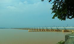
As of 2011, its population was 137,231, in 23,234 households. [4] Dehri is home to the Indrapuri Barrage, the fourth-longest barrage in the world. [5]
Males were 72,372 and females 64,859. The average literacy rate was 81.2%, higher than the national average of 74%. Male literacy was 87.54% and female literacy 74.08%. The population of children in age group 0–6 years was 19,010, of which boys were 9,886 and girls 9,124.
Important industries in Dehri include sawmilling and ghee processing. [2] Other important commodities include plastic pipes, light bulbs, and shoes. [4]
The headworks of the Sone canal system is located in Dehri. [2] [4]
Schools in Dehri On Sone include:-
Colleges in Dehri On Sone include:
Technical Institutes in Dehri On Sone include:
Dehri is home to a stadium, five cinemas, four auditoriums, and three public libraries. [4]
Climate data for Dehri (1981–2009, extremes 1901–2009) | |||||||||||||
---|---|---|---|---|---|---|---|---|---|---|---|---|---|
Month | Jan | Feb | Mar | Apr | May | Jun | Jul | Aug | Sep | Oct | Nov | Dec | Year |
Record high °C (°F) | 31.0 (87.8) | 36.0 (96.8) | 41.5 (106.7) | 45.0 (113.0) | 49.5 (121.1) | 47.2 (117.0) | 44.5 (112.1) | 39.4 (102.9) | 37.1 (98.8) | 39.7 (103.5) | 35.1 (95.2) | 31.7 (89.1) | 49.5 (121.1) |
Mean daily maximum °C (°F) | 23.1 (73.6) | 26.3 (79.3) | 32.8 (91.0) | 38.7 (101.7) | 40.0 (104.0) | 37.8 (100.0) | 33.6 (92.5) | 32.9 (91.2) | 32.4 (90.3) | 31.7 (89.1) | 29.2 (84.6) | 25.3 (77.5) | 32.0 (89.6) |
Mean daily minimum °C (°F) | 7.4 (45.3) | 9.6 (49.3) | 13.9 (57.0) | 19.0 (66.2) | 21.3 (70.3) | 22.4 (72.3) | 21.5 (70.7) | 20.7 (69.3) | 20.2 (68.4) | 16.4 (61.5) | 10.4 (50.7) | 6.7 (44.1) | 15.8 (60.4) |
Record low °C (°F) | −1.0 (30.2) | 0.0 (32.0) | 1.5 (34.7) | 3.0 (37.4) | 5.0 (41.0) | 13.5 (56.3) | 11.4 (52.5) | 11.0 (51.8) | 10.8 (51.4) | 4.0 (39.2) | 0.0 (32.0) | 0.0 (32.0) | −1.0 (30.2) |
Average rainfall mm (inches) | 10.9 (0.43) | 21.5 (0.85) | 8.6 (0.34) | 11.7 (0.46) | 39.3 (1.55) | 125.6 (4.94) | 340.6 (13.41) | 288.6 (11.36) | 192.6 (7.58) | 44.3 (1.74) | 3.5 (0.14) | 6.3 (0.25) | 1,093.6 (43.06) |
Average rainy days | 1.1 | 1.6 | 0.9 | 1.0 | 2.4 | 6.3 | 15.0 | 12.8 | 8.6 | 2.2 | 0.3 | 0.6 | 52.9 |
Average relative humidity (%) (at 17:30 IST) | 62 | 57 | 42 | 31 | 37 | 54 | 75 | 78 | 79 | 72 | 61 | 60 | 58 |
Source: India Meteorological Department [19] [20] |
The CD block of Dehri contains 58 rural villages, all of which are inhabited: [4]
Village name | Total land area (hectares) | Population (in 2011) |
---|---|---|
Panruhar | 557 | 1,803 |
Gohi | 123 | 1,353 |
Gonuwan | 69 | 720 |
Maudiha | 136 | 1,727 |
Shiwpur | 78 | 590 |
Barawan | 279 | 4,521 |
Ahirawan | 176 | 1,942 |
Khudrawan | 120 | 1,439 |
Chilbila | 97 | 1,380 |
Parsawan | 55 | 1,307 |
Tanrwa | 210 | 1,177 |
Majhiawan | 195 | 1,839 |
Ayar Kotha | 53 | 1,138 |
Darihat | 1,123 | 11,953 |
Bhusahula | 291 | 2,953 |
Chainpur | 311 | 876 |
Berkap | 454 | 2,893 |
Bharkunria | 184 | 1,885 |
Ahibaranpur | 121 | 2,065 |
Hurka | 320 | 1,982 |
Sidhauli | 22 | 2,320 |
Gangauli | 447 | 5,279 |
Pahleza | 338 | 6,464 |
Shiupur | 59 | 932 |
Deuria | 284 | 2,939 |
Tendua Dusadhi | 239 | 2,660 |
Mahdewa | 175 | 1,298 |
Chormara | 74 | 25 |
Jamuhar | 368 | 6,228 |
Rudarpura | 210 | 1,121 |
Chakia | 264 | 2,362 |
Manaura | 70 | 625 |
Mathuri | 180 | 3,581 |
Sakhara | 405 | 5,820 |
Suara | 267 | 2,584 |
Dahaur | 276 | 2,802 |
Patpura | 219 | 1,617 |
Bharkunria | 320 | 1,737 |
Guraila | 146 | 1,933 |
Durgapur | 170 | 1,461 |
Bhatauli | 162 | 1,558 |
Wojhaulia | 19 | 731 |
Ghonghaha | 96 | 1,865 |
Khairaha | 135 | 1,853 |
Bhainsaha | 64 | 2,833 |
Bastipur | 451 | 2,159 |
Katar | 853 | 3,368 |
Bardiha | 94 | 1,477 |
Sujanpur | 109 | 1,750 |
Manikpur | 53 | 1,814 |
Bhaluari | 475 | 6,821 |
Nawadih | 422 | 4,000 |
Dudhmi | 134 | 1,705 |
Shahpur | 103 | 89 |
Chaknaha | 155 | 1,831 |
Shankarpur | 120 | 2,056 |
Sikaria | 619 | 559 |
Patanawa | 528 | 1,983 |
Sone River, also spelt Son River, is a perennial river located in central India. It originates near Amarkantak Hill in Pendra, Chhattisgarh and finally merges with the Ganga river near Maner in Patna, Bihar. The Sone River is the second-largest southern tributary of the Ganges after the Yamuna River. India's oldest river bridge Koilwar Bridge over Sone River connects Arrah with Patna. Sone river is famous for its sand across country. Multiple dam(s) and hydro-electric projects run on its course towards Ganges.
Sasaram, also spelled as Shahsaram, is a historical city and a municipal corporation region in the Rohtas district of Bihar state in eastern India.
Rohtas District is one of the thirty-eight districts of Bihar state, India. It came into existence when Shahabad District was bifurcated into Bhojpur & Rohtas in 1972. Administrative headquarter of the district is Sasaram. Rohtas district has the highest literacy in Bihar. The literacy rate of Rohtas district which is 73.37% as per 2011 census is highest among all 38 districts of Bihar.
Kalanaur is a tehsil in Gurdaspur District of Punjab state in India. It is located 25 km towards west from District headquarters Gurdaspur. This historical town is situated on newly constructed National Highway 354. The town has historical significance as Mughal Emperor Akbar, was enthroned in a garden near the Kalanaur by Bairam Khan. It was first Established as a Principality by Prince Nakhashena, a brother of King Janamejaya. He Established the Principality which was further ruled by his descendants known as Jarral Rajputs. Jarral rule in Kalanaur lasted for 350 Years
Bikramganj is a nagar parishad city and corresponding community development block of Rohtas district, Bihar, India. At the time of the 2011 census, the city of Bikramganj had a population of 48,465, in 7,968 households, while the overall subdistrict had a population of 163,565. The main commodities produced in Bikramganj are rice and pulses. The city of Bikramganj has a slum called Dhangai which, in 2011 had a population of 3,955 in 637 households. Bikramganj is located at 25.2°N 84.25°E. It has an average elevation of 77 metres (252 feet).
Daudnagar is a town and the subdivisional headquarter of Daudnagar Subdivision in Aurangabad district in the state of Bihar, India under the Magadh division. Until 1991, there was only one Subdivision in the Aurangabad district: Aurangabad Sadar. On 31 March 1991, one other subdivision, Daudnagar, was created. Daudnagar is a 200-year-old historical city and its living proof is Daudnagar has an old historical fort situated on the eastern bank of the Son River. National Highway NH139 which connects Jharkhand's Palamu district to Patna, passes through the town.
Basawon Singh or Basawan Singh also known as Basawon Sinha, was an Indian independence activist and a campaigner for the rights of the underprivileged, industrial labourers and agricultural workers.
Indrapuri Barrage is across the Son River in Rohtas district in the Indian state of Bihar.
Nasriganj is a nagar panchayat town and corresponding community development block situated in Rohtas District of Bihar, India. Located on the banks of the Son River, the town was a vibrant economic hub in the late 19th century. The town of Nasriganj had a population of 23,819, according to the 2011 Census of India, while the total population of Nasriganj block was 115,117. Besides the town of Nasriganj itself, the block consisted of 53 villages, of which 50 were inhabited and 3 were uninhabited.
Tilothu, also spelled Tilauthu or Tilothu, is a village and corresponding community development block in Rohtas district, Bihar, India. It is located 15 km from Dehri-on-Sone on the west bank of the Son River. As of 2011, the population of Tilouthu was 16,402, in 2,745 families, while the corresponding block population was 109,249.
Veer Kunwar Singh University was established on 22 October 1992 with its headquarters at Arrah, under the Bihar University Act 1976 [as amendment Act 9 of 1992]. It is named after Kunwar Singh, the well-known national hero and a distinguished freedom fighter of 1857.
Maudihan is a village in the Rohtas District of Bihar state, India. It is 14 km north of Dehri-On-Sone, an industrial city. It is located on Dehri-Patna road. It is also referred to as 'Maudiha'.
Bastipur is a village and a municipality in Rohtas district in the state of Bihar, India.
Nehru Setu is a railway bridge across the Son River, connecting Dehri-on-Son and Son Nagar, in Bihar.
Nowgong is a city of Chhatarpur district of Madhya Pradesh. The town had a population of 11,507 in 1952. Vindhya Pradesh was merged into Madhya Pradesh on 1 November 1956. Nowgaon was declared capital of Madhya Pradesh, but after six months Bhopal became the capital of Madhya Pradesh.
Medininagar, formerly Daltonganj, is a city municipal corporation in the Indian state of Jharkhand. It is the headquarters of Palamu division and Palamu district, as well as the subdivision and block of the same name. The city is situated on the banks of the North Koel River.
Dehri-on-Sone railway station is on the Gaya–Pandit Deen Dayal Upadhyaya Junction section of the Grand Chord line. It stands next to the Nehru Setu and serves Dehri and the surrounding areas in Rohtas district in the Indian state of Bihar. It's located on the banks of Son river, a tributary of river Ganges.
Dehri Rohtas Light Railway (DRLR) was a 2 ft 6 in narrow gauge railway line between Dehri-On-Sone and Tiura Pipara Dih in the state of Bihar, India.
Shamshernagar is a large village in the Daudnagar subdivision and block in Aurangabad district, located in Bihar, India. The town falls under the jurisdiction of the Magadh division. Situated on the bank of the Sone River, the National Highway 139 passes through the village. The Indrapuri Barrage canal is a local waterway. Shamshernagar is densely populated. It has adequate infrastructure, including a middle school, an intermediate high school, an additional Primary Health Centre, and a Regional Rural Bank (MBGB). Shamshernagar is an electrified village. and possesses a water tank for its water supply. It shares a border between Aurangabad and Arwal districts. Buses, auto-rickshaws and e-rickshaws provide regional transportation.
Akorhi Gola is a village and corresponding community development block in Rohtas district of Bihar, India. Located 6 km north of Dehri, Akorhi Gola is known for its blanket weaving industry. As of 2011, the village had a population of 3,810, in 601 households, while the total block population was 120,145.