Nauhatta, Rohtas

Last updated

Nauhatta
Village
Nauhatta block map.png
India Bihar location map.svg
Red pog.svg
Nauhatta
Location in Bihar, India
Coordinates: 24°33′01″N83°48′42″E / 24.5504°N 83.8116°E / 24.5504; 83.8116 Coordinates: 24°33′01″N83°48′42″E / 24.5504°N 83.8116°E / 24.5504; 83.8116 [1]
CountryIndia
State Bihar
District Rohtas
Area
[2]
  Total4.97 km2 (1.92 sq mi)
Population
 (2011)
  Total5,103 [2]
Languages
  Official Hindi
Time zone UTC+5:30 (IST)

Nauhatta is a village and corresponding community development block in Rohtas district of Bihar, India. As of 2011, the village of Nauhatta had a population of 5,103, in 909 households, while Nauhatta block had a population of 94,065, in 16,387 households. The nearest city is Dehri. [2]

Contents

Geography

Parts of Nauhatta block are located on the Rohtas plateau. There is no irrigation system in place in Nauhatta block; many parts of the block are hilly and unsuitable for irrigation. The area of Nauhatta block is 39,494 hectares, including 10,402.4 hectares of forest, while the area of Nauhatta village is 497 hectares. [2]

Demographics

Historical population
YearPop.±%
2001 75,864    
2011 94,065+24.0%
Source: 2011 Census of India [2]

Nauhatta is an entirely rural subdistrict, with no major urban centres. The block's sex ratio was 916 in 2011. The sex ratio was higher in the 0–6 age group, where it was 936. Members of scheduled castes made up 19.47% of the block population and members of scheduled tribes made up 11.88% (the latter percentage was the highest in Rohtas). The literacy rate of Nauhatta block was 63.07%, lowest in Rohtas, with a 23.02% literacy gap between men (74.05%) and women (51.03%). [2]

Of the village of Nauhatta's 5,103 residents in 2011, 2,581 (50.58%) were male and 2,522 (49.42%) were female. 13.78% of the population was in the 0–6 age group. The literacy rate was 62.32% (69.20% among men and 55.27% among women). [3]

Employment

The village of Nauhatta had 1,752 total workers in 2011, of whom 1,207 (68.89%) were male and 545 (31.11%) were female. There were a total of 386 cultivators (321 male and 65 female) who owned or leased their own land, 946 agricultural labourers (555 male and 391 female) who worked someone else's land for wages, 87 household industry workers (60 male and 27 female), and 333 other workers (271 male and 62 female). [3]

Amenities

In 2011, 19.08% of Nauhatta block households lived in permanent pucca houses, 58.74% lived in semi-permanent houses, and 21.99% lived in temporary kutcha houses. 3.19% of households primarily used tap water as a source of drinking water, 16.17% primarily used wells, and 78.92% primarily used hand pumps. In terms of lighting, 20.91% of households had electric lights and 77.9% used kerosene lamps. 5.79% of households had flush toilets, with 0.8% being connected to sewers and 4.51% to septic tanks; a large majority of block residents had no toilet at home, with 93.31% using open defecation. In terms of cooking, most households (79.55%) used firewood as fuel, with 13.38% using cow dung and 5.72% using crop residue. Most households (74.81%) did not have a kitchen at home; 20.41% did have kitchens. 58.53% of households had access to banking services. [3]

20% of households owned radios in 2011, 12.91% had televisions, 0.5% had a computers with internet access and 7.07% had computers without internet, 1.67% had landline telephones and 55.31% had cell phones (1.52% had both), 43.01% had bicycles, 5.15% had motor scooters, motorcycles, or mopeds, and 1.36% had automobiles. 27.76% had none of the above items. [3]

Villages

Nauhatta is one of 68 villages in Nauhatta block. Of these, 65 are inhabited and 3 are uninhabited. [2]

Village nameTotal land area (hectares)Population (in 2011)
Chunda8,5891,860
Piparadih 5,1463,700
Katudanr232287
Basarhi2260
Gurur950
Mujuraha640
Tiara Khurd2951,340
Tiara Kalan767960
Nawadih Khurd507954
Amahuan598347
Madhkupia432962
Matiawan6371,412
Nawadih Kalan366948
Jadunathpur1,1171,658
Belduria401235
Jaradag1,058454
Parchha 6494,458
Paruka3852,688
Tilokhar 4963,626
Pararia7341,557
Tiura, Rohtas 2,1315,563
Banua3421,112
Dumaria75351
Chaphla248559
Chaukhara6549
Lohara2632,560
Nauhatta (block headquarters)4975,103
Hama112806
Birki94108
Paharia149461
Karamdiha1581,101
Sihaldeh264552
Bhaunathpur54874
Uli Banahi 6473,490
Mada Tipa44154
Tipa40746
Dhanauti274115
Baijalpur98190
Adhaura340263
Saguna7655
Bhurwa522743
Rehal 3,3963,160
Dewadand3711,585
Nimahath3072,024
Jaintipur4922,270
Anandi Chak1321,265
Naudiha1101,233
Balbhadarpur96623
Hankarpur77480
Nawadih286226
Nawara293415
Kazipur100872
Baraicha3351,429
Kamal Khairwa2472,325
Auraiya64791
Amarkha3106
Bandu4651,078
Khairwa Khurd91877
Bhadara 6943,686
Khandaul7090
Saraidanr1391,600
Baliari152498
Singhpur3561,106
Shahpur 2724,026
Bishunpur921,566
Gurisot1811,103
Bhangia44779
Daranagar 1,0356,551

The village of Chunda is the largest village in Rohtas district in terms of physical area. [3]

Related Research Articles

<span class="mw-page-title-main">Rohtas district</span> District of Bihar in India

Rohtas District is one of the thirty-eight districts of Bihar state, India. It came into existence when Shahabad District was bifurcated into Bhojpur & Rohtas in 1972. Administrative headquarter of the district is Sasaram. Rohtas district has the highest literacy in Bihar. The literacy rate of Rohtas district which is 73.37% as per 2011 census is highest among all 38 districts of Bihar.

<span class="mw-page-title-main">Bikramganj</span> City in Bihar, India

Bikramganj is a nagar panchayat city and corresponding community development block of Rohtas district, Bihar, India. As of 2011, the city of Bikramganj had a population of 48,465, in 7,968 households, while the overall subdistrict had a population of 163,565. The city of Bikramganj has a slum called Dhangai which, in 2011 had a population of 3,955 in 637 households.

<span class="mw-page-title-main">Nokha, Rohtas</span> Town in Bihar, India

Nokha is a nagar panchayat town and corresponding community development block in Rohtas district in the Indian state of Bihar. As of 2011, the population of the town of Nokha was 27,302 in 4,381 households. The rural population of Nokha block was 146,025, thus bringing the total block population 173,327. The economic situation of this region is mainly dependent on parboiled rice processed by number of rice mills in this area.

<span class="mw-page-title-main">Kochas</span> Town in Bihar, India

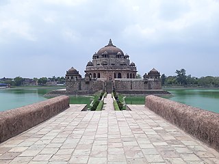
Kochas is a town and corresponding community development block in Rohtas district of Bihar state, India. It is located at an elevation of 69 m above MSL. National Highway 30 passes through Kochas. The nearest airport is Varanasi Airport .The most famous cultural event of Kochas is Krishn Lila unfortunately it is known and famous as "Kans Lila". Beside Krishn Lila other famous cultural activities are Chhath Puja, Durga Puja and other religious functions. Kochas's Surya Mandir sun temple is identity of Kochas. It is situated in center of a Pond "Pokhara". It was established on 1 October (SS).

Goalpokhar II is a community development block that forms an administrative division in Islampur subdivision of Uttar Dinajpur district in the Indian state of West Bengal.

<span class="mw-page-title-main">Cooch Behar I</span> Community development block in West Bengal, India

Cooch Behar I is a community development block that forms an administrative division in the Cooch Behar Sadar subdivision of the Cooch Behar district in the Indian state of West Bengal.

<span class="mw-page-title-main">Cooch Behar II</span> Community development block in West Bengal, India

Cooch Behar II is a community development block that forms an administrative division in the Cooch Behar Sadar subdivision of the Cooch Behar district in the Indian state of West Bengal.

<span class="mw-page-title-main">Sitai</span> Community development block in West Bengal, India

Sitai is a community development block that forms an administrative division in the Dinhata subdivision of the Cooch Behar district in the Indian state of West Bengal.

Sitalkuchi is a community development block that forms an administrative division in the Mathabhanga subdivision of the Cooch Behar district in the Indian state of West Bengal.

Mathabhanga I is a community development block that forms an administrative division in the Mathabhanga subdivision of the Cooch Behar district in the Indian state of West Bengal.

Mekhliganj is a community development block that forms an administrative division in the Mekhliganj subdivision of the Cooch Behar district in the Indian state of West Bengal.

Haldibari is a community development block that forms an administrative division in the Mekhliganj subdivision of the Cooch Behar district in the Indian state of West Bengal.

Tufanganj I is a community development block that forms an administrative division in the Tufanganj subdivision of the Cooch Behar district in the Indian state of West Bengal.

Tufanganj-II is a community development block that forms an administrative division in Tufanganj subdivision of Cooch Behar district in the Indian state of West Bengal.

<span class="mw-page-title-main">Dinara, Bihar</span> Village in Bihar, India

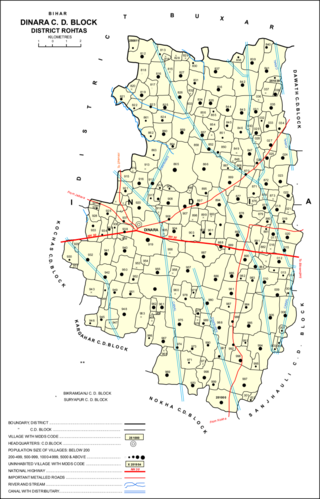
Dinara is a regional market in Rohtas district, Bihar, India, near the National Highway 30. The birthplace of the famous poet Dariya Saheb is just 5 km from Dinara.

<span class="mw-page-title-main">Sheosagar</span> Village in Bihar, India

Sheosagar, also spelled Shiusagar or Shivsagar, is a village and corresponding community development block in Rohtas district of Bihar, India. As of 2011, the village of Sheosagar had a population of 2,065, in 345 households, while the entire block had a population of 176,080. The nearest major city is Sasaram, the capital of Rohtas district.

<span class="mw-page-title-main">Chenari, India</span> Census town in Bihar, India

Chenāri or Chanāri is a census town and corresponding community development block in Rohtas district of Bihar, India. As of 2011, the town of Chenari had a population of 6,569, while Chenari block had a population of 131,528. Major commodities produced in the town of Chenari are chironji, rice, and pulses. The census town of Bhardua is administratively counted as part of Chenari block.

<span class="mw-page-title-main">Rohtas block</span> Place in Bihar, India

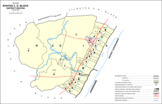
Rohtas is a community development block in Rohtas district of Bihar, India. The block headquarters is in the village of Akbarpur, 5 km east of the historic Rohtas Fort. As of 2011, the population of Rohtas block was 86,049.

<span class="mw-page-title-main">Akorhi Gola</span> Village in Bihar, India

Akorhi Gola is a village and corresponding community development block in Rohtas district of Bihar, India. Located 6 km north of Dehri, Akorhi Gola is known for its blanket weaving industry. As of 2011, the village had a population of 3,810, in 601 households, while the total block population was 120,145.

<span class="mw-page-title-main">Suryapura, India</span> Village in Bihar, India

Suryapura, also spelled Surajpura, is a village and corresponding community development block in Rohtas district of Bihar, India. As of 2011, the village of Suryapura had a population of 6,347, in 900 households, while Suryapura block had a population of 57,529, in 8,728 households. It is the least populous of Rohtas's 19 blocks.

References

  1. "Mapcarta.com. Nauhatta" . Retrieved 3 July 2020.
  2. 1 2 3 4 5 6 7 "Census of India 2011: Bihar District Census Handbook – Rohtas, Part A (Village and Town Directory)". Census 2011 India. pp. 33, 41–70, 868–899, 1191–1192. Retrieved 3 July 2020.
  3. 1 2 3 4 5 "Census of India 2011: Bihar District Census Handbook – Rohtas, Part B (Village and Town Wise Primary Census Abstract)". Census 2011 India. pp. 13, 260–265, 373–399. Retrieved 9 July 2020.