Irrigation in India includes a network of major and minor canals from Indian rivers, groundwater well based systems, tanks, and other rainwater harvesting projects for agricultural activities. Of these groundwater system is the largest. [1] In 2013–14, only about 36.7% of total agricultural land in India was reliably irrigated, [2] and remaining 2/3 cultivated land in India is dependent on monsoons. [3] 65% of the irrigation in India is from groundwater. [4] Currently[ when? ] about 51% of the agricultural area cultivating food grains is covered by irrigation. The rest of the area is dependent on rainfall which is most of the times unreliable and unpredictable.
Indian government launched a demand side water management plan costing ₹6000 crore or USD854 million across 8,350 water stressed villages of 78 districts in seven states – Gujarat, Haryana, Karnataka, Madhya Pradesh, Maharashtra, Rajasthan and Uttar Pradesh – over five years from 2021–22 to 2026–27, with the view to harvest rainwater, enhance water table, water recharge rate with village panchayat level water management plans. [4] Most of the canal irrigation is in the canal network of Ganges-Yamuna basin mainly in the states of Punjab, Haryana, and Uttar Pradesh and somewhat in Rajasthan and Bihar, while small local canal networks also exist in the south in Tamil Nadu, Karnataka, and Kerala. [5] The largest canal in India is Indira Gandhi Canal, which is about 650 km (400 mi) long. [3] India has an ambitious river linking national project to enhance the coverage of canal-irrigated area, reduce floods and water shortage. [6] [7]
Irrigation in India helps improve food security, reduce dependence on monsoons, improve agricultural productivity and create rural job opportunities. Dams used for irrigation projects help produce electricity and transport facilities, as well as provide drinking water supplies to a growing population, control floods and prevent droughts. [6]
The earliest mentions of irrigation are found in Rigveda chapters 1.55, 1.85, 1.105, 7.9, 8.69 and 10.101. [8] The Veda mentions only well-style irrigation, [9] where kupa and avata wells once dug are stated to be always full of water, from which varatra (rope strap) and cakra (wheel) pull kosa (pails) of water. This water was, state the Vedas, led into surmi susira (broad channels) and from there into khanitrima (diverting channels) into fields. [8]
Later, the 4th-century BCE Indian scholar Pāṇini, mentions tapping several rivers for irrigation. [8] [10] The mentioned rivers include Sindhu, Suvastu, Varnu, Sarayu, Vipas and Chandrabhaga. [8] Buddhist texts from the 3rd century BCE also mention irrigation of crops. [9] Texts from the Maurya Empire era (3rd century BCE) mention that the state raised revenue from charging farmers for irrigation services from rivers. [8] [11]
Patanjali, in Yogasutra of about the 4th century CE, explains a technique of yoga by comparing it to "the way a farmer diverts a stream from an irrigation canal for irrigation". [12] [13] In Tamil Nadu, the Grand Anicut (canal) across the Kaveri river was implemented in the 3rd century CE, and the basic design is still used today. [11]
The most widespread irrigation system in India was undertaken in India in the medieval period by the Sultanate rulers. Firoz Shah Tughlaq (1309–1388) built the most extensive canal irrigation system around the Indo-Gangetic doab and the region west of the river Yamuna in the fourteenth century. These canals provided vast resources of water to agricultural lands in northern India as well as vital supplies of water to urban and rural settlements. [14] These irrigation projects were continued by the subsequent rulers of northern India, particularly the Mughal rulers till the early eighteenth century. The British built the colonial canal networks on these medieval canal systems. [15]
In 1800, some 800,000 hectares were irrigated in India. [11] The Britishers by 1940 built significant number of canals and irrigation systems in Uttar Pradesh, Bihar, [16] Punjab, Assam and Orissa. [17] The Ganges Canal reached 350 miles from Haridwar to Kanpur in Uttar Pradesh. In Assam, a jungle in 1840, by 1900 had 1.62m hectares under cultivation, especially in tea plantations. In all, the amount of irrigated land multiplied by a factor of eight. Historian David Gilmour states British colonial government had built irrigation network with Ganges canal and that, "by the end of the century the new network of canals in the Punjab" were in place. [18]
Much of the increase in irrigation during British colonial era was targeted at dedicated poppy and opium farms in India, for exports to China. [19] [20] [21] Poppy cultivation by the British Raj required reliable, dedicated irrigation system. [22] Large portions of the eastern and northern regions of India, namely United Provinces, Northwestern Provinces, Oudh, Behar, Bengal and Rewa were irrigated to ensure reliable supply of poppy and opium for China. [23] By 1850, the Asian opium trade created nearly 1,000 square kilometers of poppy farms in India in its fertile Ganges plains, which increased to over 200.000 hectares by 1900. [23] This diversion of food crop land to cash crop use, state scholars, led to massive famines over the 1850 to 1905 period. [24] [25]
Major irrigation canals were built after millions of people died each in a series of major famines in the 19th century in British India. [11] [25] In 1900, British India (including Bangladesh and Pakistan) had about 13 million ha under irrigation. In 1901 the Viceroy, Lord Curzon, appointed a Commission chaired by Sir Colin Scott-Moncrieff to draw up a comprehensive irrigation plan for India. In 1903 the Commission's report recommended irrigation of an additional 2.6 million hectares. [26] [27] By 1947, the irrigated area had increased to about 22 million ha. [11] In Northwestern British India region alone, with the colonial government's effort, 2.2 million hectares of previously barren land was irrigated by the 1940s, most of which is now part of Pakistan. [28] Arthur Cotton led some irrigation canal projects in the Deccan peninsula, and landmarks are named after him in Andhra Pradesh and Tamil Nadu. However, much of the added irrigation capacity during the colonial era was provided by groundwater wells and tanks, operated manually. [29]
India's irrigation covered crop area was about 22.6 million hectares in 1951, and it increased to a potential of 90 mha at the end of 1995, inclusive of canals and groundwater wells. [31] However, the potential irrigation relies on reliable supply of electricity for water pumps and maintenance, and the net irrigated land has been considerably short. According to 2001/2002 Agriculture census, only 58.13 million hectares of land was actually irrigated in India. [32] The total arable land in India is 160 million hectares (395 million acres). According to the World Bank, only about 35% of total agricultural land in India was reliably irrigated in 2010. [2]
The ultimate sustainable irrigation potential of India has been estimated in 1991 United Nations' FAO report to be 139.5 million hectares, comprising 58.5 mha from major and medium river-fed irrigation canal schemes, 15 mha from minor irrigation canal schemes, and 66 mha from groundwater well fed irrigation. [31]
India's irrigation is mostly groundwater well based. At 39 million hectares (67% of its total irrigation), India has the world's largest groundwater well equipped irrigation system (China with 19 mha is second, USA with 17 mha is third). [1]
India has spent ₹ 16,590 crore on irrigation development between 1950 and 1985. Between 2000–2005 and 2005–2010, India proposed to invest a sum of ₹ 1,03,315 crore (INR) and ₹ 2,10,326 crore (INR) on irrigation and flood control in India. [33]
Tables below provide the fraction of agricultural area irrigated by state, the agricultural yield per hectare, and the proportion of different irrigation technologies employed.
State | Agricultural production (million tonnes) | Percentage of total production | Productivity (tonnes per hectare) | Percent of cultivated area under irrigation [34] |
---|---|---|---|---|
Punjab | 27.3 | 11.6 | 4.2 | 98.1 |
Haryana | 15.6 | 6.6 | 3.3 | 87.6 |
Andhra Pradesh | 20.4 | 8.7 | 2.7 | 63.9 |
Bihar | 12.2 | 5.2 | 1.7 | 63.4 |
Tamil Nadu | 7.1 | 3.0 | 2.2 | 63.1 |
West Bengal | 16.3 | 6.9 | 2.4 | 48.2 |
Gujarat | 6.4 | 2.7 | 1.5 | 44.7 |
Madhya Pradesh | 13.9 | 5.9 | 1.1 | 44.5 |
Uttarakhand | 1.7 | 6.7 | 1.7 | 42.9 |
Orissa | 7.4 | 3.1 | 1.3 | 33.6 |
Karnataka | 11.2 | 4.8 | 1.5 | 28.5 |
Chhattisgarh | 5.1 | 2.2 | 1.0 | 27.6 |
Rajasthan | 16.6 | 7.1 | 1.2 | 26.4 |
Maharashtra | 11.4 | 4.8 | 1.0 | 16.8 |
Jharkhand | 1.7 | 0.7 | 1.7 | 5.4 |
Assam | 4.1 | 1.7 | 1.5 | 4.9 |
Other States | 6.3 | 2.6 | NA | NA |
All India | 234.4 | 100 | 1.9 | 48.3 |
State | Total crop area (million hectares) | Groundwater irrigation crop area (million hectares) | Canal irrigation crop area (million hectares) | Total crop area actually irrigated (million hectares) |
---|---|---|---|---|
Andhra Pradesh | 16.6 | 2.5 | 2.7 | 4.9 |
Arunachal Pradesh | 0.4 | 0.07 | 0.05 | |
Assam | 3.2 | 0.13 | 0.1 | 0.22 |
Bihar | 6.4 | 2.2 | 1.3 | 3.5 |
Chhattisgarh | 5.1 | 0.17 | 0.74 | 0.85 |
Goa | 0.1 | 0.1 | 0.1 | |
Gujarat | 9.9 | 3.1 | 0.5 | 3.2 |
Haryana | 3.6 | 1.99 | 1.32 | 3.26 |
Himachal Pradesh | 1.0 | 0.02 | 0.09 | 0.11 |
Jammu & Kashmir | 0.9 | 0.02 | 0.38 | 0.37 |
Jharkhand | 3.2 | 0.11 | 0.13 | 0.24 |
Karnataka | 12.2 | 1.43 | 1.33 | 2.38 |
Kerala | 1.5 | 0.18 | 0.21 | 0.39 |
Madhya Pradesh | 15.8 | 2.74 | 1.70 | 4.19 |
Maharashtra | 19.8 | 3.12 | 1.03 | 3.36 |
Manipur | 0.2 | 0.05 | 0.05 | |
Meghalaya | 0.3 | 0.06 | 0.06 | |
Mizoram | 0.1 | 0.01 | 0.01 | |
Nagaland | 1.1 | 0.1 | 0.07 | |
Odisha | 4.9 | 0.17 | 1.07 | 1.24 |
Punjab | 4.0 | 3.06 | 0.94 | 3.96 |
Rajasthan | 21.1 | 3.98 | 1.52 | 5.12 |
Sikkim | 0.1 | 0.01 | 0.01 | |
Tamil Nadu | 6.5 | 1.61 | 1.43 | 2.66 |
Tripura | 0.3 | 0.02 | 0.05 | 0.07 |
Uttar Pradesh | 17.6 | 10.64 | 4.21 | 14.49 |
Uttarakhand | 0.8 | 0.22 | 0.14 | 0.35 |
West Bengal | 5.5 | 2.09 | 1.22 | 2.98 |
All India | 159.6 | 39.43 | 22.48 | 58.13 |
Note: The All India total includes land area for Union Territories of India that is not shown in the above table.
Irrigation Projects in India are classified as follows: [35] [36]
Since 1950, irrigation works were classified on the basis of cost incurred for the projects' implementation, governing and dissemination. However, the Planning Commission of India adopted the classification of projects on the basis of culturable command area (CCA).
Minor irrigation project is a classification of irrigation projects used in India. A project with a designed to irrigate an area of 2000 hectares or less is classified as a minor irrigation [37] [38] [39] Before the Fifth Five-Year Plan, irrigation schemes were classified on the basis of investments needed to implement the scheme. [37] Since the Fifth Five-Year Plan, India has adopted the command area-based system of classification. [37]
Micro Irrigation Fund (MIF) of INR 5,000 crore was established "to bring more land area under micro-irrigation as part of its objective to boost agriculture production and farmers income", NABARD offers low interest rate to state govts "to promote micro-irrigation, which currently has a coverage of only 10 million hectares as against the potential of 70 million hectares." Drip irrigationis promoted. [40]
Irrigation is the practice of applying controlled amounts of water to land to help grow crops, landscape plants, and lawns. Irrigation has been a key aspect of agriculture for over 5,000 years and has been developed by many cultures around the world. Irrigation helps to grow crops, maintain landscapes, and revegetate disturbed soils in dry areas and during times of below-average rainfall. In addition to these uses, irrigation is also employed to protect crops from frost, suppress weed growth in grain fields, and prevent soil consolidation. It is also used to cool livestock, reduce dust, dispose of sewage, and support mining operations. Drainage, which involves the removal of surface and sub-surface water from a given location, is often studied in conjunction with irrigation.
Pothundi Dam is an irrigation dam near Pothundi village in the Palakkad district of Kerala state, India. Constructed in the 19th century, it is considered one of the oldest dams in India. It provides irrigation to an area of 5,470 hectares in the Palakkad district and drinking water supply to the Nemmara, Ayalur, Melarcode Panchayat. An unusual feature of the earth dam is the core wall, which is built with a mixture of jaggery and quick lime.
The Indian rivers interlinking project is a proposed large-scale civil engineering project that aims to effectively manage water resources in India by linking rivers using a network of reservoirs and canals to enhance irrigation and groundwater recharge and reduce persistent floods in some parts and water shortages in other parts of the country. India accounts for 18% of global population and about 4% of the world's water resources. One of the solutions to solve the country's water woes is to link its rivers and lakes.
A johad, also known as a pokhar or a percolation pond, is a community-owned traditional harvested rainwater storage wetland principally used for effectively harnessing water resources in the states of Haryana, Rajasthan, Punjab, and western Uttar Pradesh of North India, that collects and stores water throughout the year, to be used for the purpose of recharging the groundwater in the nearby water wells, washing, bathing and drinking by humans and cattle. Some johads also have bricked or stones masonry and cemented ghat.
Water resources and irrigation infrastructure in Peru vary throughout the country. The coastal region, an arid but fertile land, has about two-thirds of Peru's irrigation infrastructure due to private and public investment aimed at increasing agricultural exports. The Highlands and Amazon regions, with abundant water resources but rudimentary irrigation systems, are home to the majority of Peru's poor, many of whom rely on subsistence or small-scale farming.
Lift irrigation is a method of irrigation in which water is not transported by natural flow, but is lifted with pumps or surge pools etc.
Mexico, a classified arid and semi-arid country, has a total land area of 2 million square kilometres, 23% of which is equipped for irrigated agriculture. The agricultural sector plays an important role in the economic development of the country accounting for 8.4 of agricultural gross domestic product (GDP) and employing 23% of the economically active population. Irrigated agriculture contributes about 50% of the total value of agricultural production and accounts for about 70% of agriculture exports. Mexico's government initiated a number of structural reforms in the water sector aimed to introduce modern water management and irrigation.
Irrigation in the Dominican Republic (DR) has been an integral part of DR agricultural and economic development in the 20th century. Public investment in irrigation has been the main driver for irrigation infrastructural development in the country. Irrigation Management Transfer to Water Users Associations (WUAs), formally started in the mid-1980s, is still an ongoing process showing positive signs with irrigation systems in 127,749 ha, being managed by 41,329 users. However, the transfer process and the performance of WUAs are still far from ideal. While WUAs show a significant increase in cost recovery, especially when compared to low values in areas under state management, a high subsidy from the government still contributes to cover operation and maintenance costs in their systems.
The environmental impact of irrigation relates to the changes in quantity and quality of soil and water as a result of irrigation and the subsequent effects on natural and social conditions in river basins and downstream of an irrigation scheme. The effects stem from the altered hydrological conditions caused by the installation and operation of the irrigation scheme.
River linking is a project of linking two or more rivers by creating a network of manually created reservoirs and canals, and providing land areas that otherwise does not have river water access and reducing the flow of water to sea using this means. It is based on the assumptions that surplus water in some rivers can be diverted to deficit rivers by creating a network of canals to interconnect the rivers.
Water resources management in modern Egypt is a complex process that involves multiple stakeholders who use water for irrigation, municipal and industrial water supply, hydropower generation and navigation. In addition, the waters of the Nile support aquatic ecosystems that are threatened by abstraction and pollution. Egypt also has substantial fossil groundwater resources in the Western Desert.
Irrigation in Iran covers 89,930 km2 making it the fifth ranked country in terms of irrigated area.
Costa Rica is divided into three major drainage basins encompassing 34 watersheds with numerous rivers and tributaries, one major lake used for hydroelectric generation, and two major aquifers that serve to store 90% of the municipal, industrial, and agricultural water supply needs of Costa Rica. Agriculture is the largest water user demanding around 53% of total supplies while the sector contributes 6.5% to the Costa Rica GDP. About a fifth of land under cultivation is being irrigated by surface water. Hydroelectric power generation makes up a significant portion of electricity usage in Costa Rica and much of this comes from the Arenal dam.
Water resources management in Nicaragua is carried out by the National water utility and regulated by the Nicaraguan Institute of water. Nicaragua has ample water supplies in rivers, groundwater, lagoons, and significant rainfall. Distribution of rainfall is uneven though with more rain falling on an annual basis in the Caribbean lowlands and much lower amounts falling in the inland areas. Significant water resources management challenges include contaminated surface water from untreated domestic and industrial wastewater, and poor overall management of the available water resources.
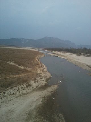
The Kankai River is a trans-boundary river flowing through the hills of Ilam and the plains of the Jhapa District in Nepal. It begins at the confluence of the Mai Khola and Deb Mai Khola rivers.
The Polavaram Project is an under construction multi-purpose irrigation project on the Godavari River in the Eluru District and East Godavari District in Andhra Pradesh. The project has been accorded National project status by the Central Government of India. Its reservoir back water spreads up to the Dummugudem Anicut and approx 115 km on Sabari River side. Thus back water spreads into parts of Chhattisgarh and Odisha States. It gives major boost to tourism sector in Godavari Districts as the reservoir covers the famous Papikonda National Park, Polavaram hydro electric project (HEP) and National Waterway 4 are under construction on left side of the river. It is located 40 km to the upstream of Sir Arthur Cotton Barrage in Rajamahendravaram City and 25 km from Rajahmundry Airport.
The Salaulim Dam is located on the Guleli River, a tributary of the Zuari River in Goa, India. It is an integral component of the Salaulim Irrigation Project which envisages benefits of irrigation and drinking water supply. The dam is a composite earth+masonry dam of 42.7 metres (140 ft) height with a water spread area of 24 km2 (9.3 sq mi).
The Bhadra Dam or Lakkavalli Dam, which has created the Bhadra Reservoir, is located on the Bhadra River a tributary of Tungabhadra River. Bhadra Dam is located in the border of Bhadravathi and Tarikere, in the western part of Karnataka in India. The benefits derived from the reservoir storage are irrigation with gross irrigation potential of 162,818 hectares, hydro power generation of 39.2 MW, drinking water supply and industrial use. The dam commissioned in 1965 is a composite earth cum masonry structure of 59.13 metres (194.0 ft) height with length of 1,708 metres (5,604 ft) at the crest level, which submerges a land area of 11,250.88 hectares.
Lakhwar-Vyasi Dam project on Yamuna River, includes under-construction Lakhwar Dam and Power Station, Vyasi Dam, Hathiari Power Station and Katapathar Barrage, near the Lakhwar town in Kalsi block of Dehradun district of Uttarakhand in India, for the purpose of irrigation of 40,000 hectare land and total 927 MW hydroelectric power generation. "Lakhwar Dam" is a gravity dam near the Lohari village with 300MW power generation capacity. "Vyasi Dam" will be built 5 km downstream along with 120 MW "Hathiari Power Station" further 0.5 km downstream. "Katapathar Barrage", with the maximum ponding water level at 514.5m elevation, will be built further 2.75 km downstream of the Hathiari Power Station to supply the water to stakeholder states. Project will hold 580 million cubic metres water during monsoon and release into Yamuna during dry months.
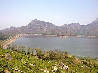
The Kanjirapuzha Dam, a masonry earth dam built for providing irrigation to a Cultural Command Area (CCA) of 9,713 hectares, is located in the Palakkad district in the Indian state of Kerala. The reservoir, which has three islands within it, also has an established commercial fisheries development programme operated by the Fisheries Department.