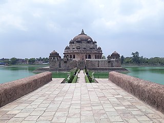
Rohtas District is one of the thirty-eight districts of Bihar state, India. It came into existence when Shahabad District was bifurcated into Bhojpur & Rohtas in 1972. Administrative headquarter of the district is Sasaram. Rohtas district has the highest literacy in Bihar. The literacy rate of Rohtas district which is 73.37% as per 2011 census is highest among all 38 districts of Bihar.

Chausa is a village and corresponding community development block in Buxar district, Bihar, India. It is located 11 km west of the district headquarters, Buxar, on the bank of the river Ganga. As of 2011, the population of the village of Chausa was 9,011, in 1,362 households, while the total block population was 103,670, in 15,817 households.

Bikramganj is a nagar panchayat city and corresponding community development block of Rohtas district, Bihar, India. As of 2011, the city of Bikramganj had a population of 48,465, in 7,968 households, while the overall subdistrict had a population of 163,565. The city of Bikramganj has a slum called Dhangai which, in 2011 had a population of 3,955 in 637 households.

Nokha is a nagar panchayat town and corresponding community development block in Rohtas district in the Indian state of Bihar. As of 2011, the population of the town of Nokha was 27,302 in 4,381 households. The rural population of Nokha block was 146,025, thus bringing the total block population 173,327. The economic situation of this region is mainly dependent on parboiled rice processed by number of rice mills in this area.

Tilothu, also spelled Tilauthu or Tilothu, is a village and corresponding community development block in Rohtas district, Bihar, India. It is located 15 km from Dehri-on-Sone on the west bank of the Son River. As of 2011, the population of Tilouthu was 16,402, in 2,745 families, while the corresponding block population was 109,249.

Kochas is a town and corresponding community development block in Rohtas district of Bihar state, India. It is located at an elevation of 69 m above MSL. National Highway 30 passes through Kochas. The nearest airport is Varanasi Airport .The most famous cultural event of Kochas is Krishn Lila unfortunately it is known and famous as "Kans Lila". Beside Krishn Lila other famous cultural activities are Chhath Puja, Durga Puja and other religious functions. Kochas's Surya Mandir sun temple is identity of Kochas. It is situated in center of a Pond "Pokhara". It was established on 1 October (SS).
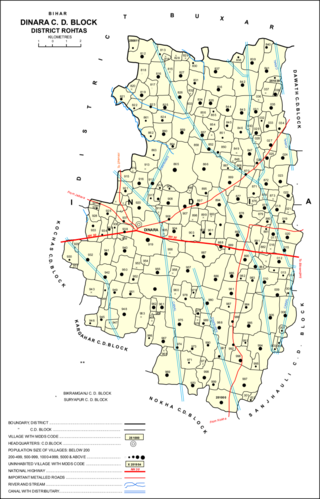
Dinara is a regional market in Rohtas district, Bihar, India, near the National Highway 30. The birthplace of the famous poet Dariya Saheb is just 5 km from Dinara.

Sahār is a village and community development block in Bhojpur district of Bihar, India. The sub-district contains 51 inhabited villages, including that of Sahar itself, with a total district population of 110,276 as of 2011. The village of Sahar has a population of 5,674, in 931 households. Sahar was a major center of conflict during the wider Naxalite insurgency in Bhojpur in the late 1960s and throughout the 1970s.

Sheosagar, also spelled Shiusagar or Shivsagar, is a village and corresponding community development block in Rohtas district of Bihar, India. As of 2011, the village of Sheosagar had a population of 2,065, in 345 households, while the entire block had a population of 176,080. The nearest major city is Sasaram, the capital of Rohtas district.

Chenāri or Chanāri is a census town and corresponding community development block in Rohtas district of Bihar, India. As of 2011, the town of Chenari had a population of 6,569, while Chenari block had a population of 131,528. Major commodities produced in the town of Chenari are chironji, rice, and pulses. The census town of Bhardua is administratively counted as part of Chenari block.
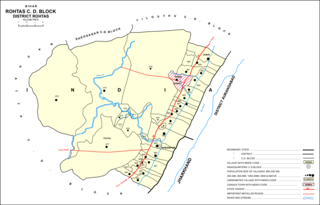
Rohtas is a community development block in Rohtas district of Bihar, India. The block headquarters is in the village of Akbarpur, 5 km east of the historic Rohtas Fort. As of 2011, the population of Rohtas block was 86,049.
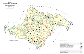
Kārākāt is a village and corresponding Community Development Block in Rohtas district of Bihar, India. As of 2011, the village of Karakat has a population of 2563, in 400 households; the total population of Karakat block is 209,284.

Akorhi Gola is a village and corresponding community development block in Rohtas district of Bihar, India. Located 6 km north of Dehri, Akorhi Gola is known for its blanket weaving industry. As of 2011, the village had a population of 3,810, in 601 households, while the total block population was 120,145.

Sanjhauli, also spelled Sajhauli, is a village and corresponding community development block in Rohtas district of Bihar, India. As of 2011, the village of Sanjhauli had a population of 7,608, in 1,269 households, while the entire block had a population of 62,621. The nearest major city is Bikramganj.

Suryapura, also spelled Surajpura, is a village and corresponding community development block in Rohtas district of Bihar, India. As of 2011, the village of Suryapura had a population of 6,347, in 900 households, while Suryapura block had a population of 57,529, in 8,728 households. It is the least populous of Rohtas's 19 blocks.
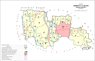
Dawath is a village and corresponding community development block in Rohtas district of Bihar state, India. The nearest city is the nagar panchayat town of Koath, which is administered as part of Dawath block.

Nauhatta is a village and corresponding community development block in Rohtas district of Bihar, India. As of 2011, the village of Nauhatta had a population of 5,103, in 909 households, while Nauhatta block had a population of 94,065, in 16,387 households. The nearest city is Dehri.

Kargahar is a village and corresponding community development block in Rohtas district of Bihar, India. As of 2011, the population of Kargahar was 10,170, in 1,464 households, while the population of Kargahar block was 225,082, in 31,528 households. The nearest city is Sasaram, the district headquarters.

Kesath is a village and corresponding community development block in Buxar district of Bihar, India. It is the least populous of Buxar's 11 blocks, with a population of 33,820, in 5,304 households. The population of Kesath itself is 14,843, in 2,351 households.

Rajpur is a village and corresponding community development block in Buxar district of Bihar, India.

