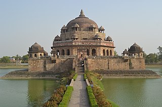
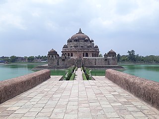
This article has multiple issues. Please help improve it or discuss these issues on the talk page . (Learn how and when to remove these template messages)
|
Bikramganj | |
---|---|
City | |
Coordinates: 25°12′N84°15′E / 25.2°N 84.25°E | |
Country | India |
State | Bihar |
District | Rohtas |
Area | |
• Total | 15.64 km2 (6.04 sq mi) |
Elevation | 77 m (253 ft) |
Population (2011) [1] | |
• Total | 48,465 |
• Density | 3,100/km2 (8,000/sq mi) |
Languages | |
• Official | Bhojpuri, Hindi |
Time zone | UTC+5:30 (IST) |
PIN | 802212 |
Telephone code | 06185 |
ISO 3166 code | IN-BR |
Website | rohtas |
Bikramganj is a nagar parishad city and corresponding community development block of Rohtas district, Bihar, India. At the time of the 2011 census, the city of Bikramganj had a population of 48,465, in 7,968 households, while the overall subdistrict had a population of 163,565. The main commodities produced in Bikramganj are rice and pulses. The city of Bikramganj has a slum called Dhangai which, in 2011 had a population of 3,955 in 637 households. [1] Bikramganj is located at 25°12′N84°15′E / 25.2°N 84.25°E . [2] It has an average elevation of 77 metres (252 feet).
It is a historical center of commercial activities developed at the crossroads connecting Patna to Sasaram and Buxar to Dehri. This crossroads is known as Bikramganj Chowk - quite an obvious landmark there. It is an emerging urban hub. Located in the "less industrialised" north of Rohtas district, surrounded by well-irrigated fertile fields which have given Rohtas the title "Rice bowl of Bihar". A railway station on Dehri Road connects to the nearby cities of Patna, Sasaram and Varanasi. Various banks have opened there as commercial activities are generating growth. Once a mundane rural town, Bikramganj is trying to catch up with the developments happening around India. A natural river called "Kao" flows through the town and debouches to Ganga in Buxar. People of all religions live here, but Hindus are in the majority. "Chhath" is a major festival here, although Bikramganj is known for "Durga Puja Mela" when all four roads compete for the best pandals and young folks throng the Chowk area. A local delicacy is "litti with chicken" and a famous sweet is "chhena ka khurma". Nearby towns are Suryapura, Karakat, Koath, Maliyabagh,Natwar and Sanjhauli. The weather is humid and sub-tropical, good for rice cultivation. "Katarni" is a famous variety of rice grown around Bikramganj.
Year | Pop. | ±% |
---|---|---|
1961 | 5,681 | — |
1971 | 14,656 | +158.0% |
1981 | 20,570 | +40.4% |
1991 | 28,898 | +40.5% |
2001 | 38,408 | +32.9% |
2011 | 48,465 | +26.2% |
Source: 2011 Census of India [1] |
In 2011, the total population of Bikramganj block was 163,565. Of these, 48,565 lived in the city of Bikramganj and 115,100 lived in rural areas. The overall population of the block increased from 136,703 in 2001 to 163,565 in 2011, representing a 19.6% increase over the decade. [1]
The sex ratio of Bikramganj was 882 in 2011, the lowest among cities in Rohtas district. The sex ratio was higher in rural areas, with 911 females for every 1000 males (the second-lowest ratio in Rohtas, ahead of Kargahar), bringing the overall sex ratio of the sub-district to 902. Again, this value was the lowest in Rohtas. The sub-district's sex ratio was also 902 among the 0-6 age group, again the lowest in Rohtas, but the distribution was somewhat different: the ratio was 894 in the city of Bikramganj itself and 906 in rural villages. [1]
The literacy rate of Bikramganj city was 74.76% in 2011, which was slightly below the Rohtas urban average of 78.35%. Literacy was higher in men than in women, with 81.37% of males but only 67.26% of females able to read and write; the corresponding 14.11% literacy gender gap was slightly above the district urban average of 13.33%. In rural parts of Bikramganj block, the literacy rate was 74.96%, slightly above the district rural average of 72.5%, with 85.56% of men and 63.33% of women able to read and write. The combined literacy rate of the entire sub-district of Bikramganj was 74.90%, slightly above the district average of 73.37%. [1]
The city of Bikramganj had one hospital as of 2011, along with two movie theatres, five nationalised banks and a community centre. The town did not have a public library at the time. [1]
All 80 inhabited villages in Bikramganj block had drinking water in 2011, but only 3 of them had tap water; most villages instead got water via well or hand pump. 57 villages had schools, serving 93.35% of the rural population. 20 had medical facilities, serving 44.69% of the rural population, and 31 had telephone access, serving 60.66% of the rural population. 10 villages had banks, 8 had agricultural credit societies, and 51 had permanent pucca roads. 58 villages had electrical power, serving 89.75% of the rural population. [1]
Anjabit Singh College, Bikramganj is one of the prestigious and oldest constituent colleges of Veer Kunwar Singh University (V.K.S.U.), Arrah, established in 1957 by Late Shri Nepal Singh, a resident of Dhawan village of Bikramganj sub-division, Rohtas. At the very outset, Justice Anand Singh and Justice Kainhaiya Singh were the members of the Governing body of this college. Shri Vishwanath Singh was the founder principal of this college. The college is imparting education in Arts and Science up to Degree levels along with post-graduate teaching in History and Economics in the faculty of Arts. It is also running B.C.A. course under the vocational/professional program. The college has well-equipped science laboratories and an adequate library, separate common rooms and toilets for boys and girls. Admissions are taken on the basis of released cut marks by college. [3]
Keeping the betterment of the students when it comes to academic, physical, and mental progress paramount is Dr. N Jha Mahila College in Rohtas. From the moment it laid its foundation in the ground the establishment became a recognized educational institute in the city. Its eminence lies not just in the academic success of its students but also in their all-around personality and the enhanced sense of maturity at a young age. Widening their horizon when it comes to their studies as well as their code of conduct when interacting with fellow mates, the college takes the initiative of molding them into better citizens. Overlooking the heart of the city, the college is considerably convenient for a number of its students. [4]
Established in the year 2008, DAV Public School is located in a Rural area of Bihar state/ut of India. School is providing Secondary level education and is being managed by Private Unaided Organisation. The medium of instruction is English language and school is Co-educational. School is affiliated with Central Board of Secondary Education (CBSE) for secondary level. [5]
Established in the year 1975, Sr. Sec. H S Tenduni is located in Urban area of Bihar state/ut of India. In Tenduni area of Bikramganj block of Rohtas district. School is providing Secondary, High Secondary (9-12) level education and is being managed by the Department of Education. The medium of instruction is Hindi language and school is Co-educational. School is affiliated with State Board Bihar School Examination Board for both secondary and high secondary level. [6]
Established in the year 1950, upgraded H S Ghusia Kalan is located in Rural area of Bihar state/ut of India. In Ghusia Kalan area of Bikramganj block of Rohtas district. School is providing Secondary level education and is being managed by the Department of Education. The medium of instruction is Hindi language and school is Co-educational. School is affiliated with State Board Bihar School Examination Board for secondary level. [7]
Established in the year 2008, Krishna Sudarshan Public School is located in Urban area of Bihar state/ut of India. School is providing Upper primary level education and is being managed by Unrecognised Body. The medium of instruction is English language and school is Co-educational.This school is located near south side of Bikramganj Railway Station. Some alumni from this school are Rajnish Gulandhiya, Ankit Aditya, Vishwajeet Mouar, Aman Lal, Amit singh. [8]
The co-educational English medium school provides basic infrastructures to its students like classrooms for all classes separately, laboratory, library facilities, having its own playground to encourage its students in various indoor and outdoor sports and games. Admissions in English medium under CBSE syllabus is provided by the school from Class 1 to High School. [9]
The Divine Public School Affiliated to C.B.S.E Delhi is run and managed by "Radhika Sriniwas Educational and Welfare Trust" a registered academic and social institution. The school was started in April 2011. This school is a unique and quality oriented co-educational school for the sake of children from standard Pre Nursery to class X, located in calm, pleasant and pollution free atmosphere at Bikramganj Rohtas, Bihar. It is designed to impact integrated education to children. Highly motivated, dedicated and competent staffs are selected to create a better academic atmosphere. The system of the D.P.S Bikramganj Rohtas, Bihar is completely based on the Central Board of Secondary Education (C.B.S.E) pattern. During this modern computer era, it is very much essential to have a proper and good knowledge of computer. Nowadays, computer is part and parcel of life. The School is well-equipped computer lab to provide enough practical knowledge of computer. Availability of generator fulfills the scarcity of electricity. [10]
Besides the city of Bikramganj, there are 100 villages in Bikrambanj block. Of these, 80 are inhabited, with a total rural population of 115,100. [1]
Village name | Total land area (hectares) | Population (in 2011) |
---|---|---|
Atrauliya | 13 | 0 |
Bhagopur | 98 | 0 |
Khirodharpur | 152 | 1,054 |
Khaira | 238 | 3,240 |
Isarpura | 117 | 948 |
Rauni | 70 | 1,001 |
Kharagpura | 60 | 531 |
Raksiya | 213 | 1,141 |
Maidhara | 100 | 876 |
Karmaini | 110 | 715 |
Bahuara | 162 | 1,596 |
Amauna | 94 | 270 |
Tekanpura | 138 | 1,000 |
Larui | 106 | 1,042 |
Kusamhra | 226 | 2,617 |
Balha | 64 | 381 |
Jalha | 43 | 594 |
Bhorna | 41 | 44 |
Jiu Khap | 16 | 0 |
Tenua | 64 | 0 |
Kharauj Khurd | 39 | 0 |
Amma Pokhar | 64 | 779 |
Nonhar | 575 | 5,992 |
Semariya | 54 | 0 |
Raghopur | 77 | 0 |
Lilkanthpur | 109 | 816 |
Dharmagatpur | 95 | 1,224 |
Paunra | 112 | 1,544 |
Balipur | 33 | 0 |
Kharhua | 175 | 1,306 |
Hunrrahaba | 36 | 163 |
Dehra | 158 | 1,110 |
Jamorhi | 280 | 3,668 |
Khaira Dih | 68 | 0 |
Bharkuriya | 85 | 179 |
Mathiya | 30 | 604 |
Bilkhoriya | 104 | 523 |
Nagi | 81 | 0 |
Amathu | 83 | 2,045 |
Durga Dih | 37 | 1,944 |
Dhawan | 105 | 2,746 |
Mangitpur | 40 | 0 |
Morauna | 260 | 3,000 |
Buchkatwa | 35 | 0 |
Baha Dih | 19 | 0 |
Kastar | 232 | 1,738 |
Inrath Khurd | 169 | 1,792 |
Kotwa Dih | 25 | 0 |
Inrath Kalan | 121 | 1,200 |
Noawan | 201 | 2,397 |
Bargaiyan | 31 | 473 |
Mohni | 302 | 4,421 |
Shiwpur | 238 | 4,346 |
Siarua | 158 | 833 |
Kukur Dih | 45 | 7 |
Gobraha | 87 | 0 |
Mahuari | 79 | 0 |
Baruna | 89 | 1,902 |
Turti | 231 | 1,791 |
Dumariya | 150 | 13 |
Silauta | 89 | 420 |
Basgitiya | 168 | 1,683 |
Parariya | 174 | 800 |
Dumariya | 69 | 371 |
Kolha | 75 | 573 |
Baluahi | 83 | 1,040 |
Padumanpur | 69 | 223 |
Manpur | 153 | 1,156 |
Bankat | 23 | 0 |
Semra | 94 | 1,111 |
Jogia | 71 | 712 |
Parsamadhopur | 75 | 514 |
Kajhai | 104 | 1,844 |
Lokaya | 40 | 707 |
Dehri Udai | 90 | 664 |
Dehrisat Sham | 27 | 0 |
Ghosiya Khurd | 134 | 1,233 |
Sahejani | 96 | 294 |
Reriya | 253 | 2,004 |
Gopalpur | 49 | 227 |
Ramnath Parasi | 53 | 0 |
Kanda Dih | 142 | 1,041 |
Balchanwan | 50 | 547 |
Dafal Dih | 66 | 77 |
Salempur | 143 | 2,000 |
Barna | 60 | 1,083 |
Jonhi | 416 | 5,059 |
Hathilpur | 38 | 0 |
Khalariya | 81 | 1,433 |
Atpa | 30 | 225 |
Gotpa | 99 | 1,800 |
Lewajit | 100 | 181 |
Ghusia | 422 | 8,567 |
Purandarpur | 131 | 269 |
Lachhmanpur | 133 | 846 |
Matuli | 166 | 945 |
Mani | 558 | 4,455 |
Niga | 249 | 1,988 |
Ramna Dihra | 211 | 2,154 |
Keshodih | 45 | 1,249 |
Sasaram, also spelled as Shahsaram, is a historical city and a municipal corporation region in the Rohtas district of Bihar state in eastern India.
Gopalganj is one of the administrative districts in the Indian state of Bihar. The district headquarters is the town of Gopalganj, and the district is part of Saran Division. Major languages spoken are Hindi and Bhojpuri.
Rohtas District is one of the thirty-eight districts of Bihar state, India. It came into existence when Shahabad District was bifurcated into Bhojpur & Rohtas in 1972. Administrative headquarter of the district is Sasaram. Rohtas district has the highest literacy in Bihar. The literacy rate of Rohtas district which is 73.37% as per 2011 census is highest among all 38 districts of Bihar.
Dehri also known as Dehri-on-Sone is a Nagar parishad and corresponding community development block in Rohtas district in the state of Bihar, India. Situated on the banks of Sone River, Dehri is a railway hub, and is adjoining Dalmianagar that used to be an industrial town.
Nasriganj is a nagar panchayat town and corresponding community development block situated in Rohtas District of Bihar, India. Located on the banks of the Son River, the town was a vibrant economic hub in the late 19th century. The town of Nasriganj had a population of 23,819, according to the 2011 Census of India, while the total population of Nasriganj block was 115,117. Besides the town of Nasriganj itself, the block consisted of 53 villages, of which 50 were inhabited and 3 were uninhabited.
Nokha is a nagar panchayat town and corresponding community development block in Rohtas district in the Indian state of Bihar. As of 2011, the population of the town of Nokha was 27,302 in 4,381 households. The rural population of Nokha block was 146,025, thus bringing the total block population 173,327. The economic situation of this region is mainly dependent on parboiled rice processed by number of rice mills in this area.
Tilothu, also spelled Tilauthu or Tilothu, is a village and corresponding community development block in Rohtas district, Bihar, India. It is located 15 km from Dehri-on-Sone on the west bank of the Son River. As of 2011, the population of Tilouthu was 16,402, in 2,745 families, while the corresponding block population was 109,249.
Bhojpur district is one of the thirty-eight districts of the Indian state of Bihar. Arrah city is the administrative headquarters of this district. Bhojpur district came into existence in 1972. Earlier it was the part of Shahabad district. This district is named "Bhojpur" after great Parmara King Bhoja as most early settlers were Rajput rulers of Parmara dynasty then called as Ujjainiya.
Kochas is a town and corresponding community development block in Rohtas district of Bihar state, India. It is located at an elevation of 69 m above MSL. National Highway 319 passes through Kochas. The nearest airport is Varanasi Airport (105 km).The most famous cultural event of Kochas is Krishn Lila unfortunately it is known and famous as "Kans Lila". Beside Krishn Lila other famous cultural activities are Chhath Puja, Durga Puja and other religious functions. Kochas's Surya Mandir sun temple is identity of Kochas. It is situated in center of a Pond "Pokhara". It was established on 1 October (SS).
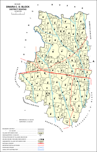
Dinara is a CD Block in Rohtas district, Bihar, India. It is situated on the National Highway 319. The birthplace of the famous poet Dariya Saheb is just 5 km from Dinara.
Mokar is a Village located in Sasaram tehsil of Rohtas district in Bihar, India. It is situated 5 km away from Sasaram, which is both district & sub-district headquarter of Mokar village. As per 2009 stats, Mokar village is also a gram panchayat.
Sheosagar, also spelled Shiusagar or Shivsagar, is a village and corresponding community development block in Rohtas district of Bihar, India. As of 2011, the village of Sheosagar had a population of 2,065, in 345 households, while the entire block had a population of 176,080. The nearest major city is Sasaram, the capital of Rohtas district.
Rohtas is a community development block in Rohtas district of Bihar, India. The block headquarters is in the village of Akbarpur, 5 km east of the historic Rohtas Fort. As of 2011, the population of Rohtas block was 86,049.
Akorhi Gola is a village and corresponding community development block in Rohtas district of Bihar, India. Located 6 km north of Dehri, Akorhi Gola is known for its blanket weaving industry. As of 2011, the village had a population of 3,810, in 601 households, while the total block population was 120,145.
Sanjhauli, also spelled Sajhauli, is a village and corresponding community development block in Rohtas district of Bihar, India. As of 2011, the village of Sanjhauli had a population of 7,608, in 1,269 households, while the entire block had a population of 62,621. The nearest major city is Bikramganj.
Suryapura, also spelled Surajpura, is a village and corresponding community development block in Rohtas district of Bihar, India. As of 2011, the village of Suryapura had a population of 6,347, in 900 households, while Suryapura block had a population of 57,529, in 8,728 households. It is the least populous of Rohtas's 19 blocks.
Dawath is a village and corresponding community development block in Rohtas district of Bihar state, India. The nearest city is the nagar panchayat town of Koath, which is administered as part of Dawath block.
Kargahar is a village and corresponding community development block in Rohtas district of Bihar, India. As of 2011, the population of Kargahar was 10,170, in 1,464 households, while the population of Kargahar block was 225,082, in 31,528 households. The nearest city is Sasaram, the district headquarters.
Suryadev Singh is a former Indian politician based in Bihar, who was elected to Bihar Legislative Assembly twice from Bikramganj Assembly constituency of Rohtas district. He was first elected to Bihar Legislative Assembly as the candidate of Indian People's Front in 1990 Bihar Legislative Assembly election. Later, he defected to Rashtriya Janata Dal and in a run up to 1995 Bihar Legislative Assembly election, he was again elected to Bihar Legislative Assembly, this time, on the symbol of Rashtriya Janata Dal. Before his retirement from politics, following his conviction in a murder case, he was a member of Janata Dal (United). The Bikramganj Assembly constituency ceased to exist after 2005, after the delimitation of constituencies.
Mani is a village near Bikramganj, in the Rohtas district of Bihar state, India. The total population of the village is 4,455 as per 2011 Census of India, spread across 558 hectares. The population is roughly equally divided between male and female, with a male population of 2,321 and a female population of 2,134.