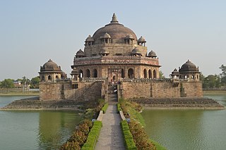
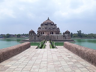
Sasaram, also spelled as Shahasaram, is a historical city and a municipal corporation region in the Rohtas district of Bihar state in eastern India.
Rohtas District is one of the thirty-eight districts of Bihar state, India. It came into existence when Shahabad District was bifurcated into Bhojpur & Rohtas in 1972. Administrative headquarter of the district is Sasaram. Rohtas district has the highest literacy in Bihar. The literacy rate of Rohtas district which is 73.37% as per 2011 census is highest among all 38 districts of Bihar.
Bikramganj is a nagar parishad city and community development block in Rohtas district, Bihar, India. In the 2011 census, Bikramganj had a population of nearly 4 lakh in 17,968 households. The main commodities produced in Bikramganj are rice and pulses. It has a slum known as Dhangai, which had a 2011 population of 3,955 in 637 households. Bikramganj is located at 25.2°N 84.25°E, and has an average elevation of 77 metres (252 feet).

Dehri also known as Dehri-on-Sone is a Nagar parishad and corresponding community development block in Rohtas district in the state of Bihar, India. Situated on the banks of Sone River, Dehri is a railway hub, and is adjoining Dalmianagar that used to be an industrial town.

Nasriganj is a nagar panchayat town and corresponding community development block situated in Rohtas District of Bihar, India. Located on the banks of the Son River, the town was a vibrant economic hub in the late 19th century. The town of Nasriganj had a population of 23,819, according to the 2011 Census of India, while the total population of Nasriganj block was 115,117. Besides the town of Nasriganj itself, the block consisted of 53 villages, of which 50 were inhabited and 3 were uninhabited.

Nokha is a nagar panchayat town and corresponding community development block in Rohtas district in the Indian state of Bihar. As of 2011, the population of the town of Nokha was 27,302 in 4,381 households. The rural population of Nokha block was 146,025, thus bringing the total block population 173,327. The economic situation of this region is mainly dependent on parboiled rice processed by number of rice mills in this area.

Tilothu, also spelled Tilauthu or Tilothu, is a village and corresponding community development block in Rohtas district, Bihar, India. It is located 15 km from Dehri-on-Sone on the west bank of the Son River. As of 2011, the population of Tilouthu was 16,402, in 2,745 families, while the corresponding block population was 109,249.
Maudihan is a village in the Rohtas District of Bihar state, India. It is 14 km north of Dehri-On-Sone, an industrial city. It is located on Dehri-Patna road. It is also referred to as 'Maudiha'.
Banjari is a small town at the south-western tip of Bihar state, India. It is located on the Sone River, the largest of the Ganges' southern tributaries, in Rohtas district. It is framed by the Kaimur mountain range, to the south-east of Sasaram.
Jamuhar is a village in the Rohtas district of Bihar, India.

Kochas is a town and corresponding community development block in Rohtas district of Bihar state, India. It is located at an elevation of 69 m above MSL. National Highway 319 passes through Kochas. The nearest airport is Varanasi Airport (105 km).The most famous cultural event of Kochas is Krishn Lila unfortunately it is known and famous as "Kans Lila". Beside Krishn Lila other famous cultural activities are Chhath Puja, Durga Puja and other religious functions. Kochas's Surya Mandir sun temple is identity of Kochas. It is situated in center of a Pond "Pokhara". It was established on 1 October (SS).
Maharorh is a village in Rohtas district, Bihar state, India. Maharorh is a gram panchayat. The language spoken in Maharorh is Bhojpuri. Agriculture is the main occupation.
Mahuari is a village in Akorhi Gola in Pakidya Pancahyat in the Rohtas district of the Indian state of Bihar. Most of the inhabitants belong to the Brahmin and Yadav castes. It has a temple of the Goddess Durga and Khadeswari Maharaj.
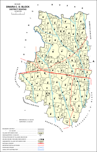
Dinara is a CD Block in Rohtas district, Bihar, India. It is situated on the National Highway 319. The birthplace of the famous poet Dariya Saheb is just 5 km from Dinara.
Manik Chowk is a village in the Indian state of Bihar.

Dehri Rohtas Light Railway (DRLR) was a 2 ft 6 in narrow gauge railway line between Dehri-On-Sone and Tiura Pipara Dih in the state of Bihar, India.

Mokar is a Village located in Sasaram tehsil of Rohtas district in Bihar, India. It is situated 5 km away from Sasaram, which is both district & sub-district headquarter of Mokar village. As per 2009 stats, Mokar village is also a gram panchayat.

Sheosagar, also spelled Shiusagar or Shivsagar, is a village and corresponding community development block in Rohtas district of Bihar, India. As of 2011, the village of Sheosagar had a population of 2,065, in 345 households, while the entire block had a population of 176,080. The nearest major city is Sasaram, the capital of Rohtas district.

Akorhi Gola is a village and corresponding community development block in Rohtas district of Bihar, India. Located 6 km north of Dehri, Akorhi Gola is known for its blanket weaving industry. As of 2011, the village had a population of 3,810, in 601 households, while the total block population was 120,145.
Gara is a village in Rohtas district of Bihar state, India. It is located in Kochas community development block.The total geographical area of Gara is 3.87 KM2. Gara village is a gram panchayat.The nearest police station is Kochas Police station. Gara is part of Kargahar vidhan sabha seat of State Assembly and Sasaram Lok Sabha constituency.


