Nasriganj

Last updated

Nasriganj
Nāsriganj
Nasriganj block map.png
India Bihar location map.svg
Red pog.svg
Nasriganj
Location in Bihar, India
India location map 3.png
Red pog.svg
Nasriganj
Nasriganj (India)
Coordinates: 25°03′05″N84°19′42″E / 25.0514°N 84.32839°E / 25.0514; 84.32839 [1]
CountryIndia
State Bihar
District Rohtas
Languages
  Official Bhojpuri, Hindi, Urdu
Time zone UTC5:30 (IST)
PIN
821310
Telephone code06185
Vehicle registration BR 24
Nearest cityDehri/Sasaram
Lok Sabha constituencyKarakat
Vidhan Sabha constituencyNokha

Nasriganj is a nagar panchayat town and corresponding community development block situated in Rohtas District of Bihar, India. Located on the banks of the Son River, the town was a vibrant economic hub in the late 19th century. The town of Nasriganj had a population of 23,819, according to the 2011 Census of India, while the total population of Nasriganj block was 115,117. Besides the town of Nasriganj itself, the block consisted of 53 villages, of which 50 were inhabited and 3 were uninhabited. [2]

Contents

Name

Nasirganj takes its name from a Sufi name Mir Nasir Dehlavi, who came to the village in late 19th century. His mausoleum is situated at the center of Nasriganj.[ citation needed ]

History

The town of Nasriganj dates back to 1740, when the eponymous Abdul Nasir settled here on the Arrah-Sasaram road. [2]

Nasriganj was formerly ruled by a local native dynasty. In 1867, the last ruler died without heirs, and the estate escheated to the British government. At this time, it was an important commercial and manufacturing centre, with 21 paper mills and 42 sugar refineries. It lost much of its importance in the ensuing years, and was downgraded from town to village status, but by 1921 it was still described as a notable trade centre, along with nearby Hariharganj. At that time, it possessed a large turbine-powered mill that produced oil, sugar, and flour, and paper was still manufactured on a smaller scale. The population of Nasriganj in 1921 was 5,332. [3]

Nasriganj was raised to nagar panchayat status in 2011. [2]

Economy

Today, the main commodities manufactured in Nasriganj are blankets, furniture, and bricks. [2]

There is a market place named Izhar Market in downtown Nasriganj. This is a big market considering population of the village having more than 30 shops. This market is a big attraction for people coming from nearby villages. Apart from this market, there some more attractions for people nearby. There is a big vegetable and food grain market and produces like potatoes, rice and gur are exported from this market. Beside this there is mini hydro power station on canal. There is one post office, telephone exchange and Nasriganj police station under Dy.S.P.

There are more markets in Nasriganj such as Aslam Market.

The main occupation of people of Nasriganj is fishing.

This whole area has some of the most fertile land of the country and is very well irrigated through a canal network all because of 18th century Zamindar Ram Varan Tiwary . So as well connected via road one side with Dehri-on-sone and other side with Bikramganj. The Son River is one of the widest rivers of the country and remains undried all year. So as the name suggests River Son = sona means gold, it makes the people rich in terms of food and even enriching them in all aspects of life and is like a lifeline for the area. Son River is also one of the cleanest rivers till date in the entire world as there are no industries & major cities upstream of this river, so in one way this river also helps in terms of keeping a check on the Ganges pollution level, as this river merges with the Ganges near Patna for its final journey to the Bay of Bengal.

At present time a famous company is working it is called Baloo Ghat company. It is a mining company of "silicate" which is found in Sone River. It currently (2016) is a main source of income of this block. It is a contract-based company but it has changed the economic culture of this area.

"Ara Line" canal is lifeline of this block. The source of this canal is Sone River and passed through three districts of this area. 180 km long this canal is a basic source of irrigation water.

A very special sweet of Nasriganj is "Khoorma" and "laktho" made from cottage cheese.

There is a "Gandhi Maidan" nearby Sone river. Children go there to play cricket and all other sports.

Academic centers

Nasriganj has one of the oldest high schools in the district Rohtas. It was founded in 1929 and at that time only two other high schools were nearby (namely Osaw High school and Burhwal High School). So this place has been one of the prime location for studying up to high school. This school has now been upgraded up to higher secondary level.

Transport

Nasriganj (Rohtas district) is situated around 6 km west of Daudnagar (Aurangabad district).

Roads

Railway

List of villages

As of 2011, Nasriganj block consisted of 53 villages, of which 50 were inhabited and 3 were uninhabited. [2]

Village nameTotal land area (hectares)Population (in 2011)
Tilsa641,291
Amalawa142.4404
Parasia160.32,377
Darekhap105.61,166
Shankarpur215.42,216
Mauna2273,702
Turkaulia37.31,177
Rampur18.20
Ramadih87546
Gamharia62.3704
Pauni316.43,274
Ghoghaha37.2363
Pipardih240.91,697
Babhandih100.2804
Baradih1021,251
Panapur147.3349
Dehri122.33,228
Maraujhia109.73,345
Ojhwalia64.3700
Dhanawan English 450.45,869
Kath Khaulia53.9474
Chargoria66.4729
Itamha121.43,606
Dhanawan Khalsa32.3535
Balia1702,472
Bardiha254.23,256
Mednipur227.82,173
Agini100.8538
Paiga181.71,822
Bagea76907
Khiriawan1,012.97,778
Sabari434.23,183
Kaithi5994,118
Kacchawa293.453,725
Mangrawan1,4108,484
Mahadewa519.33,330
Atimi775.83,504
Pokharaha Jamalpur273.64,565
Jina90.22,536
Manauli114.61,786
Chitokhar1401,509
Amiawar 776.27,412
Khutaha94.8943
Sabdala528.61,546
Bharkol42.4512
Sohra270.7142
Ghari143.61,319
Madhopur75.71,037
Mangitpur77.3555
Sahgi144.91,932
Panruri388.44,226
Kaithi Mahazi3000
Kachhawa Mahazi1810

Related Research Articles

<span class="mw-page-title-main">Sone River</span> Second-largest tributary of Ganga river in India

Sone River, also spelt Son River, is a perennial river located in central India. It originates near Amarkantak Hill in Pendra, Chhattisgarh and finally merges with the Ganga river near Maner in Patna, Bihar. The Sone River is the second-largest southern tributary of the Ganges after the Yamuna River. India's oldest river bridge Koilwar Bridge over Sone River connects Arrah with Patna. Sone river is famous for its sand across country. Multiple dam(s) and hydro-electric projects run on its course towards Ganges.

<span class="mw-page-title-main">Sasaram</span> City in Bihar, India

Sasaram, also spelled as Shahsaram, is a historical city and a municipal corporation region in the Rohtas district of Bihar state in eastern India.

<span class="mw-page-title-main">Rohtas district</span> District of Bihar in India

Rohtas District is one of the thirty-eight districts of Bihar state, India. It came into existence when Shahabad District was bifurcated into Bhojpur & Rohtas in 1972. Administrative headquarter of the district is Sasaram. Rohtas district has the highest literacy in Bihar. The literacy rate of Rohtas district which is 73.37% as per 2011 census is highest among all 38 districts of Bihar.

Bikramganj is a nagar parishad city and corresponding community development block of Rohtas district, Bihar, India. At the time of the 2011 census, the city of Bikramganj had a population of 48,465, in 7,968 households, while the overall subdistrict had a population of 163,565. The main commodities produced in Bikramganj are rice and pulses. The city of Bikramganj has a slum called Dhangai which, in 2011 had a population of 3,955 in 637 households. Bikramganj is located at 25.2°N 84.25°E. It has an average elevation of 77 metres (252 feet).

Daudnagar is a town and the subdivisional headquarter of Daudnagar Subdivision in Aurangabad district in the state of Bihar, India under the Magadh division. Until 1991, there was only one Subdivision in the Aurangabad district: Aurangabad Sadar. On 31 March 1991, one other subdivision, Daudnagar, was created. Daudnagar is a 200-year-old historical city and its living proof is Daudnagar has an old historical fort situated on the eastern bank of the Son River. National Highway NH139 which connects Jharkhand's Palamu district to Patna, passes through the town.

<span class="mw-page-title-main">Dehri</span> Urban Area in Bihar, India

Dehri also known as Dehri-on-Sone is a Nagar parishad and corresponding community development block in Rohtas district in the state of Bihar, India. Situated on the banks of Sone River, Dehri is a railway hub, and is adjoining Dalmianagar that used to be an industrial town.

<span class="mw-page-title-main">Koilwar</span> Indian town in Bhojpur district, Bihar

Koilwar or Koelwar is a nagar panchayat (town) and one of the 14 community development block in Bhojpur district in the Indian state of Bihar. As of 2011, the population of Koilwar town was 17,725, in 2,893 households. Koilwar lies on the Arrah-Patna highway (NH-922).

<span class="mw-page-title-main">Indrapuri Barrage</span> Dam in Bihar, India

Indrapuri Barrage is across the Son River in Rohtas district in the Indian state of Bihar.

<span class="mw-page-title-main">Tilouthu</span> Town in Bihar, India

Tilothu, also spelled Tilauthu or Tilothu, is a village and corresponding community development block in Rohtas district, Bihar, India. It is located 15 km from Dehri-on-Sone on the west bank of the Son River. As of 2011, the population of Tilouthu was 16,402, in 2,745 families, while the corresponding block population was 109,249.

Maudihan is a village in the Rohtas District of Bihar state, India. It is 14 km north of Dehri-On-Sone, an industrial city. It is located on Dehri-Patna road. It is also referred to as 'Maudiha'.

Banjari is a small town at the south-western tip of Bihar state, India. It is located on the Sone River, the largest of the Ganges' southern tributaries, in Rohtas district. It is framed by the Kaimur mountain range, to the south-east of Sasaram.

Saraon is a village situated in Rohtas District of Bihar state, India. It is 20 km. from the Dehri-on-Son railway station on the way to Bikramganj via Nasriganj.

<span class="mw-page-title-main">Bastipur, India</span> Village in Bihar, India

Bastipur is a village and a municipality in Rohtas district in the state of Bihar, India.

Dalmianagar is a town that had one of the oldest and biggest industry in India. It is situated at Dehri-on-Sone on the banks of the Son River in Rohtas district of Bihar. This is a city and a Municipality in Rohtas district in the state of Bihar, India, combinedly known as Dehri-Dalmianagar Nagar Palika.

<span class="mw-page-title-main">Dehri-on-Sone railway station</span> Railway station in Bihar

Dehri-on-Sone railway station is on the Gaya–Pandit Deen Dayal Upadhyaya Junction section of the Grand Chord line. It stands next to the Nehru Setu and serves Dehri and the surrounding areas in Rohtas district in the Indian state of Bihar. It's located on the banks of Son river, a tributary of river Ganges.

<span class="mw-page-title-main">Sanjhauli</span> Village in Bihar, India

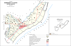
Sanjhauli, also spelled Sajhauli, is a village and corresponding community development block in Rohtas district of Bihar, India. As of 2011, the village of Sanjhauli had a population of 7,608, in 1,269 households, while the entire block had a population of 62,621. The nearest major city is Bikramganj.

<span class="mw-page-title-main">Suryapura, India</span> Village in Bihar, India

Suryapura, also spelled Surajpura, is a village and corresponding community development block in Rohtas district of Bihar, India. As of 2011, the village of Suryapura had a population of 6,347, in 900 households, while Suryapura block had a population of 57,529, in 8,728 households. It is the least populous of Rohtas's 19 blocks.

Jalpura Tapa is a village and gram panchayat in Koilwar block, Bhojpur district in the Indian state of Bihar. Situated close to the Sone River, it is a large village with more than 12,000 residents. Population-wise it is the largest village and area-wise, it is the 2nd-largest village of Koilwar block.

State Highway 81 (SH-81) is a state highway in Bihar, India. It covers two major districts of Bihar. This state highway starts from Sakaddi near Arrah and ends at Nasriganj near Dehri-on-Sone and Daudnagar. SH-81 is also known as the Chandi-Nasriganj road.

State Highway 15 (SH-15) is a state highway in Bihar state. It covers only one districts i.e. Rohtas district of Bihar state. This state highway starts from Nasriganj near Daudnagar and ends at NH-19 near Dehri-on-Sone. The Dehri-on-Sone is situated between Sasaram and Aurangabad.

References

  1. "Geonames.org. Nāsriganj" . Retrieved 15 April 2020.
  2. 1 2 3 4 5 "Census of India 2011: Bihar District Census Handbook - Rohtas, Part A (Village and Town Directory)". Census 2011 India. pp. 33, 44–70, 96–99, 572–595, 1191–1192. Retrieved 16 April 2020.
  3. O'Malley, L.S.S. (1924). Bihar and Orissa District Gazetteers Shahabad. New Delhi: Logos Press. p. 174. ISBN   9788172681227 . Retrieved 16 April 2020.