Muzaffarpur | |
---|---|
City | |
Muzaffarpur Junction | |
Coordinates: 26°7′21″N85°23′26″E / 26.12250°N 85.39056°E | |
Country | ![]() |
State | ![]() |
District | Muzaffarpur |
Division | Tirhut |
Established | 1 January 1875 |
Municipal Corporation | Muzaffarpur Municipal Corporation |
Government | |
• Member of Parliament | Raj Bhushan Choudhary |
• Member of Legislative Council | Dinesh Prasad Singh |
• Member of Legislative Assembly | Vijendra Chaudhary [1] |
• Mayor | Nirmala Sahu |
Area | |
• Total | 91 km2 (35 sq mi) |
Elevation | 60 m (200 ft) |
Population (2011) | |
• Total | 354,462 [2] |
• Rank | 4th (Bihar) 127th (India) |
Language Other Local Language | |
• Official | Hindi [3] |
• Additional official | English [3] |
• Regional Languages | Bajjika [4] |
Time zone | UTC+5:30 (IST) |
PIN | 842001-05 (Muzaffarpur) [5] |
Telephone code | 0621 |
Vehicle registration | BR-06 |
Sex ratio | 890 (females per thousand males) [6] ♂/♀ |
Literacy | 85.16% [6] |
Lok Sabha constituency | Muzaffarpur |
Vidhan Sabha constituency | Muzaffarpur |
Website | muzaffarpur |
Muzaffarpur (ⓘ ) is a city located in Muzaffarpur district in the Tirhut region of the Indian state of Bihar. [6] [2] It serves as the headquarters of the Tirhut division, the Muzaffarpur district, and the Muzaffarpur Railway District. It is the fourth most populous city in Bihar.
Muzaffarpur is known for Shahi litchis and is known as the Lychee Kingdom. [7] [8] Shahi lychee is the fourth product from Bihar to get the Geographical Indication (GI) tag, after jardalu mango, katarni rice and Magahi paan (betel leaf). The city is situated on the banks of the perennial Budhi Gandak River, which flows from the Someshwar Hills [9] of the Himalayas.
The current city was established in 1875 during the British Raj for administrative convenience, by dividing the Tirhut district and was named after an aumil , Muzaffar Khan; thus the city came to be known as Muzaffarpur. [10]
The city was founded in 18th century during British Raj period and was constituted a municipality in 1864. A major road and rail hub, it is a trade centre on the route between Patna (south) and Nepal (north). Lychee, sweet corn, mango, vegetables, rice and sugar milling alongside cutlery manufacturing are the chief industries. [11]
In 1972, the Sitamarhi and Vaishali districts were split off from Muzaffarpur. [12]
Muzaffarpur is located at 26°07′N85°24′E / 26.12°N 85.4°E . [13] The city lies in a highly active seismic zone of India. In the disastrous earthquake on 15 January 1934, much of the town suffered severe damage and many people died. [14] It has an average elevation of 47 meters (154 feet). This saucer shaped, low-centered town lies on the great Indo-Gangetic plains of Bihar, over Himalayan silt and sand brought by the glacier-fed and rain-fed meandering rivers of the Himalayas.
Muzaffarpur has a humid subtropical climate (Cwa) under the Köppen climate classification. The summer, between April and June, is extremely hot and humid (28–40 °C, 90% max). and winter is pleasantly cool, around 6-20 °C. Rainfall in Muzaffarpur City is comparatively less compared to other parts of Bihar.
Climate data for Muzaffarpur (1991–2020, extremes 1901–2009) | |||||||||||||
---|---|---|---|---|---|---|---|---|---|---|---|---|---|
Month | Jan | Feb | Mar | Apr | May | Jun | Jul | Aug | Sep | Oct | Nov | Dec | Year |
Record high °C (°F) | 30.8 (87.4) | 34.6 (94.3) | 39.4 (102.9) | 42.2 (108.0) | 44.5 (112.1) | 43.4 (110.1) | 43.5 (110.3) | 40.6 (105.1) | 38.2 (100.8) | 35.9 (96.6) | 33.2 (91.8) | 29.6 (85.3) | 44.5 (112.1) |
Mean daily maximum °C (°F) | 21.7 (71.1) | 26.1 (79.0) | 31.4 (88.5) | 35.8 (96.4) | 35.3 (95.5) | 35.0 (95.0) | 33.0 (91.4) | 33.1 (91.6) | 32.6 (90.7) | 32.0 (89.6) | 28.6 (83.5) | 24.1 (75.4) | 30.7 (87.3) |
Mean daily minimum °C (°F) | 10.4 (50.7) | 13.6 (56.5) | 17.8 (64.0) | 22.6 (72.7) | 25.1 (77.2) | 26.7 (80.1) | 27.0 (80.6) | 27.0 (80.6) | 26.0 (78.8) | 23.0 (73.4) | 16.8 (62.2) | 12.0 (53.6) | 20.6 (69.1) |
Record low °C (°F) | 2.7 (36.9) | 2.2 (36.0) | 7.2 (45.0) | 12.6 (54.7) | 18.3 (64.9) | 19.4 (66.9) | 20.9 (69.6) | 20.6 (69.1) | 19.6 (67.3) | 14.4 (57.9) | 7.7 (45.9) | 4.0 (39.2) | 2.2 (36.0) |
Average rainfall mm (inches) | 10.5 (0.41) | 12.5 (0.49) | 7.1 (0.28) | 20.9 (0.82) | 74.9 (2.95) | 168.6 (6.64) | 270.7 (10.66) | 276.5 (10.89) | 192.4 (7.57) | 48.5 (1.91) | 3.8 (0.15) | 2.8 (0.11) | 1,089.2 (42.88) |
Average rainy days | 0.9 | 0.9 | 0.7 | 1.5 | 4.4 | 7.0 | 12.4 | 11.9 | 8.2 | 1.7 | 0.2 | 0.3 | 50.1 |
Average relative humidity (%) (at 17:30 IST) | 79 | 70 | 57 | 52 | 63 | 74 | 82 | 83 | 83 | 78 | 76 | 80 | 73 |
Source: India Meteorological Department [15] [16] [17] |
Muzaffarpur has been ranked 32nd best "National Clean Air City" under (Category 2 3-10L Population cities) in India. [18]
As of the 2011 India census, [19] Muzaffarpur had a population of 393,724. [2] Males constituted 52.96% (208,509) of the population and females 47.04% (185,215). [2] Muzaffarpur had a literacy rate of 85.16%. Male literacy was 88.83%, and female literacy was 81.05%. [20]
As per 2011 census data, there are total 275,233 Hindus whereas 74,680 Muslims and 1,352 Christians along with other small minorities. [21]
In 2006 the Ministry of Panchayati Raj named Muzaffarpur one of the country's 250 most backward districts (out of a total of 640). [22] It is one of the 36 districts in Bihar currently receiving funds from the Backward Regions Grant Fund Programme (BRGF). [22]
The lychee crop, which is available from May to June, is mainly cultivated in the districts of Muzaffarpur and surrounding districts. Cultivation of litchi covers approximately an area of about 25,800 hectares producing about 300,000 tonnes every year. Litchi are exported to big cities of India like Mumbai, Kolkata, and even to other countries. India's share in the world litchi market amounts to less than 1%. The names of the litchi produced in Muzaffarpur are Shahi and China . The fruits are known for excellent aroma and quality. [23]
Bihar's contribution in the production of lychee in about 40 percent of lychee produced in India. [24]
Bihar has emerged as a brewery hub with major domestic and foreign firms setting up production units in the state. Vijay Mallya's group, United Breweries Group, is setting up a production unit to make litchi-flavoured wine, in Muzaffarpur in 2012. The company has leased litchi gardens. [25]
Muzaffarpur based Prabhat Zarda Factory is one of the leading tobacco manufacturers of India. [26]
The production and sales of Lahti bangles is also very prominent in city. Bollywood actress Aishwarya Rai also wore the Lahti bangles of the city at her wedding. [27]
Muzaffarpur Junction railway station (MFP) [28] is a main A1 Category railway junction in Sonpur Division of East Central Railway, having total 8 platforms, with three suburban stations, Ram Dayalu Nagar, Narayanpur Anant (Sherpur), Kaparpura and Jubba Sahni. More than 200 trains regularly visits this 136+ year old railway junction.
National Highway 57 (India) comes via Gorakhpur, Motihari, Mehsi and crosses Muzaffarpur and National Highway 57 (India) goes to Darbhanga, Purnia. The East–West Corridor crosses Muzaffarpur thus connecting it to all the major towns and cities in India. National Highway 22 (India) starting from Hajipur passes through Muzaffarpur and connects Muzaffarpur to Sitamarhi. National Highway 28 (India) connects Mehsi and Muzaffarpur to Barauni, all 6 National Highways having junction there.
Muzaffarpur Airport (IATA: MZU, ICAO: VEMZ) [29] is located in Patahi of Muzaffarpur city (besides NH 722 Muzaffarpur - Chhapra (Rewa Ghat)) in the state of Bihar, India. It was operable from 1967 to 1982, on a regular basis. Currently it is not in operations, commercially. [30]
Darbhanga Airport is the nearest domestic airport roughly 64 km away by road. Patna Airport is the nearest customs airport roughly 70 km from the city.
![]() |
Sitamarhi is an Indian city in the Mithila region of Bihar. It is the district headquarters of the Sitamarhi district in Tirhut Division. The city was named in honour of Sītā, wife of Rāma, who was born in Sitamarhi according to Hindu legends.
Darbhanga is the fifth largest city and municipal corporation in the state of Bihar in India, and is considered an important city in North Bihar. It serves as the headquarters of the Darbhanga district and the Darbhanga division. Darbhanga is also referred to as the gateway to Bengal, because it is held that the name Darbhanga has been derived from Dwār Banga or Dari – Banga, meaning the 'door of Bengal'.
Vaishali district is a district in the Indian state of Bihar. It is a part of Tirhut division. Vaishali is known for being the birthplace of Mahavira of the Jain religion. Hajipur, its largest city and district headquarters, is known for its banana forest. The district is connected via the NH-77 and NH-322 highways, Gandhi Setu and Jay Prakash Setu Bridges over(Holy) Ganga River which connect the state capital Patna, the division headquarters Muzaffarpur, and the eastward district Samastipur.
Munger, formerly spelt as Monghyr, is a twin city and a Municipal Corporation situated in the Indian state of Bihar. It is the administrative headquarters of Munger district and Munger Division. Munger was one of the major cities in Eastern India and undivided Bengal during Mughal period and British Raj. It is one of the major political, cultural, educational and commercial centers of Bihar and Eastern India. Munger is situated about 180km east of capital city Patna, about 480km west of Eastern India's largest city Kolkata and 1200km from country's capital New Delhi.
Supaul is a town and municipality that is headquarters of Supaul district in the Indian state of Bihar. Supaul is the administrative headquarters of this district. There are 11 blocks under the Supaul district: Supaul, Kishanpur, Saraigarh-Bhaptiyahi, Pipra, Triveniganj, Raghopur, Chhatapur, Nirmali, Marauna, Basantpur and Pratapganj.
West Champaran is an administrative district in the state of Bihar in India, located just 60 km (37 mi) west of Birgunj. It is the largest district in Bihar with an area of 5,228 km2(2,019sq mi). It is a part of Tirhut Division. The district headquarters are located in Bettiah. The district is known for its open border with Nepal. One of the major location in West Champaran is Kumar Bagh for SAIL Special Processing Unit and Bhitiharwa where Mahatma Gandhi started Satyagrah Aandolan.
Bettiah is a city and the administrative headquarters of West Champaran district - (Tirhut). It is near the Indo-Nepal border, 225 kilometres (140 mi) northwest of Patna, in the state of Bihar, India.
Hajipur is the headquarters and largest city of Vaishali district of the state of Bihar in India. Hajipur is the 16th most populous city of Bihar, besides being the second-fastest developing city, next to Patna. It had a total population of 1.47 lakh as per census 2011. Vaishali district is ranked 8th among 38 districts in Bihar in terms of growth.
Samastipur is one of the thirty-eight districts of Bihar in India. The district headquarters are located at Samastipur. The district occupies an area of 2904km² and has a population of 4,261,566.
Sitamarhi is one of the districts in the Mithila region of the Indian state of Bihar, India. Dumra is the administrative headquarters of this district. The district is a part of the Tirhut Division and is located along the border of Nepal.
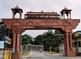
The Muzaffarpur District is one of the thirty-eight districts of Bihar state, India. Muzaffarpur district is part of and also the headquarters of Tirhut Division. Tirhut is the ancient name of all of northern Bihar.
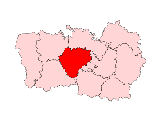
Tirhut Division or Tirhut Commissionary is an administrative-geographical unit of Bihar in India. Muzaffarpur is the headquarters of the division. It comprises six districts: Muzaffarpur, West Champaran, East Champaran, Vaishali, Sitamarhi and Sheohar.
Lalganj is an important town and Nearest City, (60 kilometres Morden Old City Mehsi), and river port situated in Vaishali district, Bihar.
Jaintpur is a village in Muzaffarpur district, Bihar state, India. Also known as Jaintpur Estate, it is situated on the banks of a Himalayan glacier-fed perennial river, the Baya Nadi River, between NH-102 (Saraiya) and NH-28 (Motipur).
Kanti is an assembly constituency in Muzaffarpur district in the Indian state of Bihar. The current sitting MLA is Mohammad Israil Mansuri who won as a RJD candidate defeating his nearest rival Ajit Kumar by 10000 votes.
Vaishali Assembly constituency is an assembly constituency in Vaishali district in the Indian state of Bihar.
Umaidpur is one of the villages of Morwa Dakshni Gram panchayat in Morwa in the Samastipur District of Bihar State, India.
Veena Devi is an Indian politician serving her 2nd term as current Member of parliament from Vaishali. She is a former member of Bihar Legislative Assembly from the Gaighat constituency. In the 2019 Indian general election, she contested from Vaishali with Lok Janshakti Party and defeated Raghuvansh Prasad Singh.
Devesh Chandra Thakur is an Indian politician from the Janata Dal United, and a member of parliament representing Sitamarhi Lok Sabha constituency in Bihar, India. He is a former chairman of the Bihar Legislative Council and has served as a Cabinet Minister of Disaster Management Department in the Government of Bihar.
Shahi litchi is a variety of litchi grown in Muzaffarpur district and 2nd men rolling Mehsi and some neighbouring districts of in the Indian state of Bihar.