
Sitamarhi is an Indian city in the Mithila region of Bihar. It is the district headquarters of the Sitamarhi district in Tirhut Division. The city was named in honour of the goddess Sita, who was born in Sitamarhi in Hindu mythology.
Sheohar is an administrative district in the Mithila region of Bihar in India. The district headquarters are located at Sheohar, and the district is a part of Tirhut Division. This district was carved out of Sitamarhi district in 1994 due to the extreme efforts of Raghunath Jha, former Union Minister. Eminent Hindi Novelist, Dr. Bhagwati Sharan Mishra was the first District magistrate of Sheohar . Sivas used to have a guest house in the Mehsi town of his time, which is still located in the name of Raja Bazar in East Champaran.The district occupies an area of 349 km2 and has a population of 656,246. Sheohar is known for its greenery and cleanliness. Cadamba and teak are the principal trees of this district. Nilgai or blue bull is the regional animal of this area.

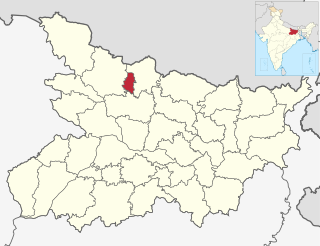
Sitamarhi is one of the districts in the Mithila region of the Indian state of Bihar, India. Dumra is the administrative headquarters of this district. The district is a part of the Tirhut Division and is located along the border of Nepal.
Janakpur Road is a town and a notified area in Sitamarhi district in the Indian state of Bihar.
Dumra is a town and a notified area in Sitamarhi district in Bihar, India. Dumra is the headquarter of Sitamarhi district. It has approximately 16 wards.
Dumari Kalan is a village in the Sitamarhi district of Bihar state, India. Dumri Kalan Urf Madhuban Jadu village is located in Majorganj Tehsil of Sitamarhi district in Bihar, India. It is situated 5 km away from sub-district headquarter Majorganj and 30 km away from district headquarter Sitamarhi. As per 2009 stats, Dumari Kala is the gram panchayat of Dumri Kalan Urf Madhuban Jadu village. The total geographical area of village is 1107 hectares. Sitamarhi is nearest town to Dumri Kalan Urf Madhuban Jadu which is approximately 36 km away. According to the 2011 census it has a population of 10667 living in 2651 households.
Gisara urf Gidhsara is an area in the Sitamarhi district of the state of Bihar, in north-east India. Due to frequent flooding, Gisara has significant alluvial deposits. Because of its geography, the area is rich in agriculture. The main market areas are around Gisara Bazar and Gisara Chauraha.
Barwa Barauli is Gram panchayat which comes under Sikta Assembly constituency of Narkatiaganj Block in West Champaran district in the Indian state of Bihar.
Rampur is a village in West Champaran district in the Indian state of Bihar.
Pokhraira is a village in Bokhra block of Sitamarhi District in Bihar state of India. It is surrounded by three main cities of Bihar, which are Muzaffarpur, Darbhanga and Sitamarhi. Pokhraira is 27 km distance from district main city Sitamarhi and 97 km distance from state capital Patna.
Rampur is a village and community development block in Kaimur district of Bihar, India. As of 2011, it had a population of 575, in 94 households. The total block population was 88,876, in 14,110 households.

Shaistabad Urf Bhurkushpur is a village in Lalganj block of Rae Bareli district, Uttar Pradesh, India. It is located 8 km from Lalganj, the block and tehsil headquarters. As of 2011, it has a population of 1,072 people, in 199 households. It has one primary school and no healthcare facilities, and it hosts a permanent market but not a weekly haat. It belongs to the nyaya panchayat of Bahai.

Rampur Khurd is a village in Sareni block of Rae Bareli district, Uttar Pradesh, India. It is located 20 km from Lalganj, the tehsil headquarters. As of 2011, it has a population of 303 people, in 65 households. It has no schools and no healthcare facilities, and it hosts a weekly haat but not a regular market. It belongs to the nyaya panchayat of Murarmau.
Raj Khand is a village in Aurai Block, Muzaffarpur District, Bihar, India. It is located on Northern Bihar, about 45 kilometres northeast of the district capital Muzaffarpur, and 14 kilometres southeast of the block capital Aurai. As of the year 2011, it is home to 19,296 inhabitants.
Aurai is a block of Muzaffarpur District, Bihar, India. Its administrative center is the village of Aurai. As of 2011, the block has a total population of 290,545.
Dhamdaha is a block of Purnia District, Bihar, India. Its seat of government is located in the village of Dhamdaha. In 2011, the block has a total population of 288,084.
Maura, or Moura Jharkaha, is a village in Shankarpur Block, Madhepura District, Bihar, India. It is located in the north of the district, approximately 19 kilometres northeast of the district capital Madhepura, and 5 kilometres north of the block capital Shankarpur. As of 2011, it has a population of 42,528.
Cheraut, or Charaut, is a town and the administrative center of Choraut Block, Sitamarhi District, Bihar, India. It is near India's northern border with Nepal, approximately 30 kilometres east of the district capital Sitamarhi. With a population of 35,976 in 2011, it is the most populous settlement within Choraut Block.
Khawaspur Diara urf Topra is a large village in Bihar, India, near the northern edge of Bhagalpur District. The village is located approximately 40 kilometres northeast of the district seat Bhagalpur, and is surrounded by the settlements of Nandi Gobind urf Chulia, Khawaspur Milik and Sangalbahita. In the 2011 census, it had a population of 35,545.

