Vaishali district is a district of Mithila region in the Indian state of Bihar. It is a part of Tirhut division. Vaishali is known for being the birthplace of Mahavira of the Jain religion. Hajipur, its largest city and district headquarters, is known for its banana forest. The district is connected via the NH-77 and NH-322 highways, which connect the state capital Patna, the division headquarters Muzaffarpur, and the eastward district Samastipur.

Hajipur is the headquarters and largest city of Vaishali district of the state of Bihar in India. Hajipur is the 16th most populous city of Bihar, besides being the second-fastest developing city, next to Patna. It had a total population of 1.47 lakh as per census 2011. Vaishali district is ranked 8th among 38 districts in Bihar in terms of growth.

Samastipur is one of the thirty-eight districts of Bihar in India. The district headquarters are located at Samastipur. The district occupies an area of 2904 km² and has a population of 4,261,566.

Sitamarhi is one of the districts in the Mithila region of the Indian state of Bihar, India. Dumra is the administrative headquarters of this district. The district is a part of the Tirhut Division and is located along the border of Nepal.

Arwal district is one of the thirty-eight districts of Bihar state, India, and Arwal town is the administrative headquarters of this district. It was earlier part of Jehanabad district.

Kaimur district is one of the 38 districts of Bihar, India. The district headquarters are at Bhabua. Before 1991, it was part of Rohtas District. Till 1764 the region was a part of Ghazipur District and was a part of Kamsaar Raj and later it was a part of Chainpur Estate till 1837.

Siwan is a city and nagar parishad in the Indian state of Bihar. It is the administrative headquarters of Siwan district and one of the urban settlements out of three in the district. It is located close to Uttar Pradesh.
Guriahati is a census town in the Cooch Behar I CD block in the Cooch Behar Sadar subdivision of the Cooch Behar district in the Indian state of West Bengal.
Lalganj is an important town and Nearest City, (60 kilometres Morden Old City Mehsi), and river port situated in Vaishali district, Bihar.
Sihaul is a village with population of about 11,000 in the sub-district of Satar Kataiya, where it ranks as the third most populous village. The sub-district forms a part of Saharsa district in the state Bihar, India. The geographical area of the village is 9 km2 (3.5 sq mi) and it is the third biggest village by area in the sub-district. Population density of the village is 1287 persons per km2.
Gisara urf Gidhsara is an area in the Sitamarhi district of the state of Bihar, in north-east India. Due to frequent flooding, Gisara has significant alluvial deposits. Because of its geography, the area is rich in agriculture. The main market areas are around Gisara Bazar and Gisara Chauraha.
Pakri Barawan is a town in the Nawada District of the Indian state of Bihar.
Ismailpur (Harauli) is a village in Vaishali district of Bihar state in India.
LakhnichakAulai is a village in Vaishali district, Bihar, India.
Ekara is a small village in Hajipur Tehsil/Block in Vaishali District in Indian state of Bihar, India. It comes under Ekara Panchayat. It belongs to Tirhut Division. It is located 9 km towards North from District headquarters Hajipur. As per 2009 stats, Thathan Buzurg is the gram panchayat of Ekara village. And 23 km from State capital Patna. Sonpur, Hajipur, Lalganj are the nearby Cities to Ekara. This Place is in the border of the Vaishali District and Saran District. Saran District Sonpur is west towards this place. Also it is in the Border of other district Patna.
Chhatanwar is a village located in Dumraon block in Buxar district of Bihar state. It is situated in the western region of the Bihar state of India. Bhojpuri is the language spoken in the village. It is situated 6 km from sub-district headquarter Dumraon and 24 km from district headquarter Buxar. As per 2009 stats, Chhatanwar village is also a gram panchayat.

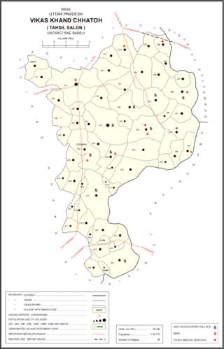
Bani is a village in Chhatoh block of Rae Bareli district, Uttar Pradesh, India. It is located 4 km from Jais, the nearest town. As of 2011, Bani has a population of 1,682 people, in 325 households. It has no schools and one mobile health clinic. It belongs to the nyaya panchayat of Hajipur.

Hajipur is a village in Chhatoh block of Rae Bareli district, Uttar Pradesh, India. It is located 36 km from Raebareli, the district headquarters. As of 2011, Hajipur has a population of 1,080 people, in 180 households. It has one primary school and no healthcare facilities. It is the headquarters of a nyaya panchayat, which also includes 5 other villages.

Hajipur is a village in Dih block of Rae Bareli district, Uttar Pradesh, India. It is located 37 km from Raebareli, the district headquarters. As of 2011, it has a population of 1,387 people, in 246 households. It has one primary school and no healthcare facilities. It belongs to the nyaya panchayat of Ahora Rampur.


