Darbhanga is the fifth largest city and municipal corporation in the state of Bihar in India, and is considered an important city in North Bihar. It serves as the headquarters of the Darbhanga district and the Darbhanga division. It is held that the name Darbhanga has been derived from Dwar Banga or Dari – Banga, meaning the 'door of Bengal'.

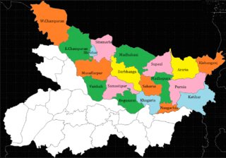
Darbhanga district is one of the thirty-eight districts of Bihar state in eastern India, and Darbhanga city is the administrative headquarters of this district and 5th largest city of Bihar as well. Darbhanga district lies in Historical Mithila region. Darbhanga district is a part of Darbhanga Division. The district is bounded on the north by Madhubani district, on the south by Samastipur district, on the east by Saharsa district and on the west by Sitamarhi and Muzaffarpur districts. The district covers an area of 2,279 km2 (880 sq mi).

Sitamarhi is one of the districts in the Mithila region of the Indian state of Bihar, India. Dumra is the administrative headquarters of this district. The district is a part of the Tirhut Division and is located along the border of Nepal.

Tirhut Division or Tirhut Commissionary is an administrative-geographical unit of Bihar in India. Muzaffarpur is the headquarters of the division. It comprises six districts: Muzaffarpur, West Champaran, East Champaran, Vaishali, Sitamarhi and Sheohar.
Janakpur Road is a town and a notified area in Sitamarhi district in the Indian state of Bihar.

Babasaheb Bhimrao Ambedkar Bihar University, formerly Bihar University, popularly known as Dr. B. R. Ambedkar Bihar University (BRABU), is a public university located in Muzaffarpur, Bihar, India. Established in 1960, the university has 38 constituent colleges and 40 affiliated colleges. It offers education from undergraduate to postgraduate and research level, as well as Distance education. It is named after B. R. Ambedkar, social reformer and the architect of Indian Constitution.
Sita Kund is a Hindu pilgrimage site that honours the birthplace of the goddess, Sita. The Punaura Dham Janki Mandir is a Hindu pilgrimage site in Sitamarhi district, Bihar, which has an ancient Hindu temple. It is situated 5 km west of Sitamarhi City and a popular visitor's attraction.

North Bihar is a term used for the region of Bihar, India, which lies north of the Ganga river.
Dharharwa is a village in Parihar Tehsil in Sitamarhi District in Bihar State, India. In Hindi: धरहरवा
Manik Chowk is a village in the Indian state of Bihar.
The Muzaffarpur–Sitamarhi section is a railway line connecting Muzaffarpur to Sitamarhi in the Indian state of Bihar. The 65.8 km (40.9 mi) line passes through the plains of North Bihar.
Jawabipur is a Colony/Nagar in Sitamarhi Municipal Corporation of Sitamarhi District, in Bihar, India. It is administered by the Sitamarhi Nagar nigam Nagar Nigam of Tirhut Division. Some are the Localities/Landmark in Jawabipur are Durga Chowk, Shakya Chowk, Hanuman Chowk, Utkramit Madhya Vidhyalaya, Hanuman Mandir, Brahm Sthan, Maharani Sthan, Athani and Bholahiya. It is situated 7 km (4.3 mi) away from sub-district headquarter Dumra and 6 km (3.7 mi) away from district headquarter Sitamarhi. Maithili and Vajjika is the Local Language here. JDU, BJP, RJD, and INC are the major political parties in this area. Nearest cities are Sitamarhi, Muzaffarpur, Darbhanga, Patna and Motihari. Most residents from Jawabipur having surname Mahto, Kushwaha, Shakya, Singh, Paswan, Sharma and Ram. Kushwaha family from Jawabipur claim that they are descent from Emperor Ashoka. Samrat Ashoka the great belongs to the Maurya dynasty, which was one of the dynasties in ancient Indian history. Chandragupt Maurya was the founder of Maurya dynasty and the first emperor to unify most of the Indian subcontinent.
Sitamarhi Junction railway station is a main railway station in Sitamarhi district, Bihar. Its code is SMI. It serves Sitamarhi City. The station consists of five platforms. It is an A category railway station of the Samastipur railway division.

Shrikhandi Bhittha or Bhitthamore is an Indian village in the Mithila region of Bihar, situated near the Indo-Nepal border, on the banks of the perennial Ratnawati (Raato) river.
The Haleshwar Sthan is a Hindu pilgrimage site in Sitamarhi in the state of Bihar,India, which has an ancient Hindu temple. It is situated 3 km north-west of Sitamarhi town.
Maa Janaki Janmbhoomi Mandir or Punaura Dham is a proposed grand temple of princess Sita in Mithila at her birthplace. The site is located at the Punaura Dham in Sitamarhi district of Bihar in India. The site is considered as the appearance place from where Sita was found closed in a box from a farm field while the King Janaka was ploughing the farm field. Ramayana Research Council has proposed the construction of the world's tallest 251-feet statue of Mother Sita at Sitamarhi. There is a plan to build Janaki Dham in Sitamarhi on the lines of Ram Mandir in Ayodhya. A grand campus known as Janaki Dham will be built on 57 acres of land near Punauradham. It is expected that the Prime Minister Narendra Modi will laid the foundation stone of the Janaki Dham before upcoming Lok Sabha Election 2024. The foundation stone of the Janaki Janmasthali Mandir was laid by the Chief Minister Nitish Kumar of Bihar on 13 December 2023 at Punauradham in Sitamarhi, the place of manifestation of Goddess Janaki.
Punaura Dham is also known as Maa Janaki Janmabhoomi Temple in Punaura village of Sitamarhi district of Bihar. It is believed that Mata Sita was born at this place.

Janaki Sthan is a historical place related to the temple of Goddess Sita in the city of Sitamarhi. According to some scholars and Saints, Janaki Sthan is claimed to be the manifestation place of Goddess Sita in Ramayana. This is a temple dedicated to the Goddess Sita called Janaki Sthan Mandir. This temple is about 2 kilometers away from Sitamarhi Railway Station. The temple comes under Ramanuja tradition in Hinduism.

Urvija Kund is a pond related to Goddess Janaki which is described in Ramayana, legendary stories and folk tales. It is believed that King Shreedhwaja Janaka had built a pond at the place where Goddess Sita was manifested, which later became famous as Urvija Kund.


