
The East Central Railway is one of the 19 railway zones in India. It is headquartered at Hajipur and comprises Sonpur, Samastipur, Danapur, Pt. Deen Dayal Upadhyaya, and Dhanbad divisions.

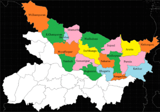
Sitamarhi is one of the districts in the Mithila region of the Indian state of Bihar, India. Dumra is the administrative headquarters of this district. The district is a part of the Tirhut Division and is located along the border of Nepal.
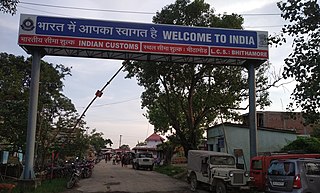
Bairgania is a town and notified area in the Sitamarhi district in the state of Bihar, India. Bairgania is one of the blocks of Sitamarhi districts and is a border of India that links Nepal via Rautahat District through a custom checkpoint. Bairgania is the first town of India that is located on the bank of the Bagmati River.It has a good government medical hospital and experience doctors such as alumni from PMCH.
Khadda is a town, a Nagar panchayat and a Tehsil in Kushinagar district in the Indian state of Uttar Pradesh. It is situated approximately 8 km from the border of Bihar and 18 km from the India-Nepal border.
Naugachia is a town and a notified area in Bhagalpur district in the Indian state of Bihar. It is a block and a division of the Bhagalpur district and also a police district.
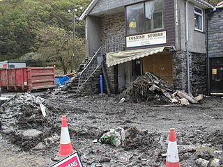
The 2004 Boscastle flood occurred on Monday, 16 August 2004 in the two villages of Boscastle and Crackington Haven in Cornwall, England, United Kingdom. The villages suffered extensive damage after flash floods caused by an exceptional amount of rain that fell over eight hours that afternoon. The flood in Boscastle was filmed and extensively reported but the floods in Crackington Haven and Rocky Valley were not mentioned beyond the local news. The floods were the worst in local memory. A study commissioned by the Environment Agency from hydraulics consulting firm HR Wallingford concluded that it was among the most extreme ever experienced in Britain. The peak flow was about 140 m3/s, between 5:00 pm and 6:00 pm BST. The annual chance of this flood in any one year is about 1 in 400. The probability each year of the heaviest three-hour rainfall is about 1 in 1300. At midday on 16 August 2004, heavy thundery showers had developed across the South West due to a weak disturbance to the northeast of the United Kingdom.
Ratwara a village in Sitamarhi district of Bihar, India also known as Vishnupur Ratwara or Bishunpur Ratwara.

Nasriganj is a nagar panchayat town and corresponding community development block situated in Rohtas District of Bihar, India. Located on the banks of the Son River, the town was a vibrant economic hub in the late 19th century. The town of Nasriganj had a population of 23,819, according to the 2011 Census of India, while the total population of Nasriganj block was 115,117. Besides the town of Nasriganj itself, the block consisted of 53 villages, of which 50 were inhabited and 3 were uninhabited.
Morsand is a village in Sitamarhi district, Bihar state, India. It is situated 18 km. to the southeast of the town of Sitamarhi on the banks of the river - Lakhandei, and is connected to the district headquarters via National Highway 77 Sitamarhi- Hajipur. The nearest railway stations are Sitamarhi and Muzaffarpur, and the nearest airport is in Patna. Now a new railway station is established in the village itself with the name "Runni Saidpur", which will be providing rail connectivity from this village to the rest of India.
Kodhiyar or Kothiar is a village in Sitamarhi district, Bihar state, India. It is situated one kilometer east from the river Bagmati four kilometers south of Dhang Railway Station, and adjacent to the village of Akhta. It is located in the Suppi subdistrict and Akhta Uttar panchayat.
Neepsend is a suburb of the city of Sheffield, it stands just 1 mile (1.6 km) north-west of the city centre. The main area of Neepsend covers the flood plain of the River Don from Lady's Bridge at the Wicker up to Hillfoot Bridge. The suburb falls within the Central Ward of the City. The adjacent district of Parkwood Springs is often regarded as part of the suburb.
Khatangi is a prominent village in Bihar, India. It is situated in Sonbhadra-Bansi-Surajpur Block in Arwal district of the State of Bihar. It is located at 96.1 km distance from Arwal and at 114 km distance from the state capital Patna. It is a very old village with a population of about 5,000 people. The literacy rate is 45.56%, comprising a female literacy rate of 27.3% and a male literacy rate of 62.98%. The people here are very friendly and hospitable. The economy of this village is agro-based and agriculture remains the main source of income.
Raghopur is a community development block in Vaishali district of Bihar. Situated between two streams of the Ganges river, it is a river island. It is connected to Patna by Pipa pul. Ancient name of Raghopur is Kotigram.
The Lakhandei River is a river in southern Nepal and in the state of Bihar in India. It is a main tributary of the Bagmati River.
North Bihar is a term used for the region of Bihar, India, which lies north of the Ganga river.
Gisara urf Gidhsara is an area in the Sitamarhi district of the state of Bihar, in north-east India. Due to frequent flooding, Gisara has significant alluvial deposits. Because of its geography, the area is rich in agriculture. The main market areas are around Gisara Bazar and Gisara Chauraha.
Manik Chowk is a village in the Indian state of Bihar.

Birpur is a village in vaishali district, Bihar which is situated at the river island called Raghopur Diyara Island. It is one of the largest village in Raghopur community block. People of this village are mostly dependent on agriculture.People in this area has long tradition of joining armed forces. Its population is approximately 20,000 and peoples of this village are living their life in peaceful manner. Birpur is named upon Raja Bir Singh, a migrant from Jodhpur in the 17th century. Most of the Villagers work outside and bring revenue to this place which helps flourish the local community and enhance purchasing power. Birpur comes under Raghopur community block and a police station is Jurawanpur. It is one of the largest village in the Raghopur block in terms of area and population. its pin code is 844508. One post office is there which is located at one its tola(blocks in village) called SatGhar. literacy rate of this village is very low around 33%. Higher education facility is not available in the village and also there is no any good hospitals, only small private clinic exists here, which is organised by non-professional or we can call it as a jhola chhap doctor means one who doesn't have any degree. Vajjika and Maithili are the languages which people speaks. It is spread over in the area of 20 km.
Pokhraira is a village in Bokhra block of Sitamarhi District in Bihar state of India. It is surrounded by three main cities of Bihar, which are Muzaffarpur, Darbhanga and Sitamarhi. Pokhraira is 27 km distance from district main city Sitamarhi and 97 km distance from state capital Patna.
Shrikhandi Bhittha or Bhitthamore is an Indian village in the Mithila region of Bihar, situated near the Indo-Nepal border, on the banks of the perennial Ratnawati (Raato) river.
