
Muzaffarpur is a city located in Muzaffarpur district in the Tirhut region of the Indian state of Bihar. It serves as the headquarters of the Tirhut division, the Muzaffarpur district and the Muzaffarpur Railway District. It is the fourth most populous city in Bihar.
East Champaran is an administrative district in the state of Bihar in India.The district headquarters are located at Motihari. Prior to 1971, there was a single district called "Champaran". On 1 December 1971, the district was divided into 2 parts East Champaran and West Champaran. In early days the land of East Chamapran was ruled by different kingdoms as Videha, Sunga, Kanvas. It is also believed that Champaran used to be a major part of King Janak's empire. Mahatma Gandhi started his famous Satyagraha movement from here.
Sheohar is the principal city of Sheohar district in Bihar, India. It is Located Northwest City 31.06 kilometres Kasba Mehsi in Mehsi It is a part of the Tirhut Division.
Bagaha is a city and a municipality in the district of Pashchim Champaran in the state of Bihar, India. It is a subdivision of Pashchim Champaran district and is a Police District. It is located around 64 kilometres (40 mi) northwest of its district headquarters Bettiah. It is 294 km (183 mi) away from Bihar's state capital Patna.
Bairgania is a town and notified area in the Sitamarhi district in the state of Bihar, India. Bairgania is one of the blocks of Sitamarhi districts and is a border of India that links Nepal via Rautahat District through a custom checkpoint. Bairgania is the first town of India that is located on the bank of the Bagmati River.It has a good government medical hospital and experience doctors such as alumni from PMCH.
Chanpatia is a city in Nagar Panchayat situated on the bank of the Burhi Gandak River. It is the administrative headquarters of the Chanpatia block in Paschim Champaran district near the Indo-Nepal border; 18 km from District headquarters Bettiah, 242 km north-west of the capital Patna in the state of Bihar, India. Chanpatia is well-known for its cuisine, such as Marcha Ka chura, Basmati rice, and Handi kabab.
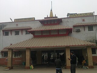
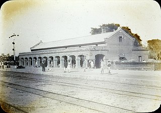
Raxaul is a sub-divisional town in the East Champaran district of the Indian state of Bihar. It is situated at the India-Nepal border with Birgunj city (Nepal). Raxaul is a major railway junction.
Lauthaha is a city and a notified area in Purvi Champaran district in the Indian state of Bihar.
Motipur is a town and a notified area in Muzaffarpur district. It is located 14 kilometres south of Mehsi in the Indian state of Bihar. In 2021, Motipur Nagar Panchayat was upgraded to Nagar Parishad.
Chakia is a town and a subdivision in East Champaran district in the Indian state of Bihar. Chakia is a sub division of East Champaran district. It is located approximately 48 Kilometres northwest of Muzaffarpur. 32 kilometers southeast of its District headquarters Motihari.
Bhawanipur is near Areraj in the Indian state of Bihar. Bhawanipur is situated at the Bank of River Budhi-Gandak which falls in Ganga Patna. Bhawanipur is situated at a distance of about 40 km from Motihari, the district headquarters of East Champaran district. The National Highway NH 28 provides the closest route to Motihari. Bhawanipur falls under the jurisdiction of Sangrampur Police Station. Bhawani Pur village has two Panchayats: South Bhawani Pur and North Bhawani Pur. The famous Someshwar Shiv Madir, is located at Areraj which is at a 15-minute drive from Bhawanipur. Bhawani Pur belongs to the Kesaria Assembly and the Purvi Champaran Lok Sabha of Bihar.

Rampurwa is a village situated in Mehsi, East Champaran District in the Indian state of Bihar. The village is commonly known as Rampurwa among the localities. It lies in the Mirjapur Panchayat region. It is situated at the bank of river Burhi Gandak River on whose bank the village has flourished. It is well connected by road and railways. The nearest city Kaswa Mehsi in Mehsi, which is 2 km from the village. The nearest railway station is Mehsi railway station, which is around 5 km from the village.
Sita Kund is a Hindu pilgrimage site that honours the birthplace of the goddess, Sita. The Punaura Dham Janki Mandir is a Hindu pilgrimage site in Sitamarhi district, Bihar, which has an ancient Hindu temple. It is situated 5 km west of Sitamarhi City and a popular visitor's attraction.
North Bihar is a term used for the region of Bihar, India, which lies north of the Ganga river.
Narkatiaganj Junction, is a railway station in the Samastipur railway division of East Central Railway. It is one of the busiest and important junctions of Samastipur division. The station is located in the town of Narkatiaganj, a sub-division of West Champaran district in the Indian state of Bihar.
Pakaridayal is a subdivision in East Champaran district in Bihar, India. It has a PIN Code as: 845428. It is 130 km from Patna. One can reach here by road mainly NH-28 towards Motihari. There are several towns and villages like Hajipur, Muzaffarpur, Kaanti, Mehsi, Motipur, Chakiya and Chorma in between Patna and Pakaridayal. This village is a Nagar Panchayat. It is situated on the bank of Budhi Gandak river, which origins from Nepal.
The Muzaffarpur–Gorakhpur line via Narkatiaganjand Motihari is a railway line connecting Muzaffarpur in the Indian state of Bihar to Gorakhpur in Uttar Pradesh. The 309.720 km (192 mi) line passes through the plains of North Bihar and the Gangetic Plain of Bihar and Uttar Pradesh.
Bapudham Motihari Railway Station is a major railway station in Motihari through which 2 lines pass one towards Muzaffarpur and other towards Sitamarhi via Sheohar, it lies in the headquarter city of East Champaran district of Bihar. Its station code is BMKI. The station mainly consists of four platforms and acts as the main station in the city of Motihari, which is being developed under 'The Amrit Bharat Station Scheme' and to celebrate 150 years of Mahatama Gandhi. In February 2022, the Indian Railways had planned to set up a railway station Development Corporation (RSDC) that would work on improving the major railway stations, including Bapudham Motihari, by building and improving passenger amenities.[4] Under the development scheme, major development works are going on Bapudham Motihari. Separate air conditioned waiting lounge, free WiFi facility, IRCTC food court and many facilities are going to be available on Bapudham Motihari at the end of 2024. To enhance the security of this station, a metal detector and baggage handling system will be installed soon.
Sagauli Junction railway station is a junction railway station in East Champaran district, Bihar. Its code is SGL. It is on the Delhi–Muzaffarpur–Gorakhpur main line

The Mehsi railway station is a railway station on Muzaffarpur–Gorakhpur main line under the Samastipur railway division of East Central Railway zone. It is located in the Indian State of Bihar district East Champaran City of Mehsi.


