Sugauli

Last updated

Sugauli
City
Sagauli
Sugauli treaty.jpg
Nickname: 
City of sugauli treaty
India Bihar location map.svg
Red pog.svg
Sugauli
Location in Bihar, India
Coordinates: 26°47′N84°44′E / 26.783°N 84.733°E / 26.783; 84.733
CountryFlag of India.svg  India
State Bihar
District Purvi Champaran
Founded byGuru Gajraj Mishra
Government
  Type Nagar panchayat
  Body Nagar panchayat Sugauli
Area
  Urban
19.25 km2 (7.43 sq mi)
  Rural
149.46 km2 (57.71 sq mi)
Elevation
75 m (246 ft)
Population
 (2011)
   Urban
38,815
   Rural
191,992
Languages
  Official Bhojpuri, Hindi
Time zone UTC+5:30 (IST)
ISO 3166 code IN-BR
Vehicle registration BR05
Lok Sabha constituency Paschim Champaran
Vidhan Sabha constituency Sugauli
Website eastchamparan.bih.nic.in

Sugauli is a city and a notified area in East Champaran district in the Indian state of Bihar. Best known for Treaty of Sagauli, 1816 between the British and Gurkhas and role played in the Satyagraha Movement of Mahatma Gandhi, it is also the setting for Rudyard Kipling's story "Rikki-Tikki-Tavi" (spelled as "Segowlee" in said story), and the place where a treaty was signed with Nepal in 1816.

Contents

Demographics

As of 2011 India census, [1] Sugauli town had a population of 38,815. Sugauli is a Nagar Panchayat city in district of Purbi Champaran, Bihar. The Sugauli city is divided into 20 wards for which elections are held every 5 years. The Sugauli Nagar Panchayat has population of 38,815 of which 20,584 are males while 18,231 are females as per report released by Census India 2011. Population of Children with age of 0-6 is 7810 which is 20.12% of total population of Sugauli (NP). In Sugauli Nagar Panchayat, Female Sex Ratio is of 886 against state average of 918. Moreover, Child Sex Ratio in Sugauli is around 937 compared to Bihar state average of 935. Literacy rate of Sugauli city is 64.90% higher than state average of 61.80%. In Sugauli, Male literacy is around 73.45% while female literacy rate is 55.10%. Sugauli Nagar Panchayat has total administration over 7,480 houses to which it supplies basic amenities like water and sewerage. It is also authorized to build roads within Nagar Panchayat limits and impose taxes on properties coming under its jurisdiction.

History

Sugauli has great role in India's independence war. Sugauli is the part of SATYAGRAHA movement what GANDHI JI has started from the Champaran, and that movement inspired a lot of youth at that time to contribute for the nation and few of them were Janardan Pandey and Babulal Mishra from Sugauli, Late Pt. Tuni jha, Laxmi Narayan Jha, Upendra Jha, Ramesh Chandra Jha, Sukham Mishra from Phulwaria, Yamuna kant Jha from Sugaon bhup narayan singh karamwa. Sugauli is also known for Sugauli Treaty, which was signed between British India and Nepal in March 1816.

Panchayats

There are 16 Gram Panchayats in sugauli block.

Villages

There are many villages around 100 in Sugauli block. Some of important villages are as follows:

Chhapwa: It connects Motihari with Bettiah via NH 28, Sugaon : Earlier it was a capital of Tirhut region (as per Gazetteer),Bhathan, Phulwaria, Panjiyarwa, Karmwa and many small villages.

List of Villages in Sugauli 1. Baghi 2. Bahuari 3. Baksa 4. Baluwa Tikulia 5. Baudha 6. Bhargawan 7. Bhataha 8. Bhawanipur 9. Biguia 10. Chainpur 11. Chhagraha 12. Chhapra Bahas 13. Chiljhapti Urf Juajat 14. Dewdatwa 15. Dumdumwa 16. Gorgawan 17. Gurhaurf Koraia 18. Hathiahiya 19. Kaithwalia 20. Khonra 21. Khutiharwa 22. Lal Parsa 23. Ledihar 24. Madhopur Bahuarwa Urf Danditol 25. Madhopurkaramwa 26. Madhopurnankar 27. Madhopurnizamat 28. Mali 29. Mansingha 30. Muda Chhapra 31. Muswa 32. Pachbhirwa 33. Pajiarwa 34. Parsauna 35. Parsurampur 36. Phulwaria 37. Phulwaria Ojha 38. Raghunathpur 39. Roypatti 40. Sapaha 41. Shampur 42. Siripur 43. Sirkhandi 44. Suganw 45. Sukul Pakar Urf Belwalia 46. Tola Dharampur 47. Unwa Birit

Transport

Railway

Sugauli is connected to different cities of India through railways. Sagauli Junction railway station is the main railway station serving the city. Direct trains are available to all the major destinations across India like Patna, Delhi, Mumbai, Kolkata, Guwahati, Ahemdabad, Lucknow, Jaipur, Jammu & Katra, etc. [2]

Roadway

National Highway 727 , 139W , 28B , AH42 and State Highway 54 passes through the city.

The National Highway Authority of India (NHAI) has notified a new Patna-Bettiah road as National Highway 139W, setting the state for construction of a high-quality four-lane road between the two towns that would reduce the distance between them to 167 kilometres from the current 200-odd km and travel time to around two hours.

Tola San Saraiyan new town aided village. The new Gopalganj-Bettiah Road passed through this new town aided village. Through this new road a distance of 60 km (37 mi) become shorten for Gopalganj-Bettiah.

Airway

The nearest airport is Kushinagar International Airport which is about 117 km (71 mi) from Sugauli. The nearest airport in bihar is Jay Prakash Narayan International Airport located in Patna which is about 200 km (120 mi) via Muzaffarpur and 177 km (110 mi) via areraj.

Also

Related Research Articles

<span class="mw-page-title-main">West Champaran district</span> District in Bihar, India

West Champaran is an administrative district in the state of Bihar in India, located just 60 km (37 mi) west of Birgunj. It is the largest district in Bihar with an area of 5,228 km2(2,019sq mi). It is a part of Tirhut Division. The district headquarters are located in Bettiah. The district is known for its open border with Nepal. One of the major location in West Champaran is Kumar Bagh for SAIL Special Processing Unit and Bhitiharwa where Mahatma Gandhi started Satyagrah Aandolan.

<span class="mw-page-title-main">Bettiah</span> City in Bihar, India

Bettiah is a city and the administrative headquarters of West Champaran district - (Tirhut). It is near the Indo-Nepal border, 225 kilometres (140 mi) northwest of Patna, in the state of Bihar, India.

<span class="mw-page-title-main">Siwan, Bihar</span> City in Bihar, India

Siwan is a city and nagar parishad in the Indian state of Bihar. It is the administrative headquarters of Siwan district and one of the urban settlements out of three in the district. It is located close to Uttar Pradesh.

Chanpatia is a city in Nagar Panchayat situated on the bank of the Burhi Gandak River. It is the administrative headquarters of the Chanpatia block in Paschim Champaran district near the Indo-Nepal border; 18 km from District headquarters Bettiah, 242 km north-west of the capital Patna in the state of Bihar, India. Chanpatia is well-known for its cuisine, such as Marcha Ka chura, Basmati rice, and Handi kabab.

<span class="mw-page-title-main">Prakash Jha</span> Indian film director and producer (born 1952)

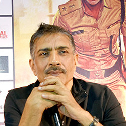
Prakash Jha is an Indian film producer, actor, director and screenwriter, mostly known for his political and socio-political films such as Hip Hip Hurray (1984), Damul (1984), Mrityudand (1997), Gangaajal (2003), Apaharan (2005), and his multi-starrer films, Raajneeti (2010), Aarakshan (2011), Chakravyuh (2012), and Satyagraha (2013). He is also the maker of National Film Award winning documentaries like Faces After The Storm (1984) and Sonal (2002).

<span class="mw-page-title-main">Babasaheb Bhimrao Ambedkar Bihar University</span> State University in Bihar

Babasaheb Bhimrao Ambedkar Bihar University, formerly Bihar University, popularly known as Dr. B. R. Ambedkar Bihar University (BRABU), is a public university located in Muzaffarpur, Bihar, India. Established in 1960, the university has 38 constituent colleges and 40 affiliated colleges. It offers education from undergraduate to postgraduate and research level, as well as Distance education. It is named after B. R. Ambedkar, social reformer and the architect of Indian Constitution.

<span class="mw-page-title-main">Mehsi</span> City in Bihar, India

Mehsi is a CD Block and Mehsi Nagar Panchayat City and a municipality in the Purvi Champaran district in the Indian state of Bihar. It is a part of the Tirhut Division. The town is the entry point of the Purvi Champaran district. There are many smaller factories manufacturing buttons for the clothing Industry, although most of the population depends upon commercial business and Business agriculture.

<span class="mw-page-title-main">Saran district</span> District in Bihar, India

Saran district is one of the 38 districts of Indian state of Bihar. The district, part of Saran Division, is also known as Chhapra district after the headquarters of the district, Chhapra.

Mashrakh is a Block and town of Saran District in the western part of Bihar, India. It is located on the right bank of Ghoghari river. It is situated at 40 km from Chhapra and 98 km from state capital Patna. There are 17 Panchayats in Mashrakh Block.

<span class="mw-page-title-main">Ramesh Chandra Jha</span> Indian poet, novelist and freedom fighter

Ramesh Chandra Jha was an Indian poet, novelist and freedom fighter. Son of a senior gandhian and freedom fighter Lakshmi Narayan Jha, who also contributed in Indian Freedom Struggle from Bihar. His maternal grandson Sanjeev K Jha is well-known Screenwriter who is working in Indian film industry. Ramesh Chandra Jha's poems, ghazals and stories evoke patriotism and human values. Romanticism and struggle of life are also important aspects of his writing. His poetry expresses concerns of people's life struggle, their dreams and hopes.

<span class="mw-page-title-main">Uttar Bihar Gramin Bank</span> Italian regional rural bank

Uttar Bihar Gramin Bank is a regional rural bank (RRB) in the State of Bihar, India. It is under the ownership of Ministry of Finance, Government of India. It is one of the largest regional rural banks in India in terms of branch network, staff strength and area of operation.

<span class="mw-page-title-main">Madhopur, Siwan</span> Village in Bihar, India

Madhopur is a village in Barharia block of Siwan district in the Indian state of Bihar. It is located 2 kilometers (1.24 mi) north of the Barharia block at Barharia-Gopalganj road, It is located 18 kilometres (11 mi) east of the district headquarters Siwan and 150 kilometres (93 mi) from the state capital Patna. Madhopur is surrounded by Sahpur to the north, Barasra south, Chhatisi east, and Rasulpur to the west. Barharia, Siwan, Gopalganj, Mirganj, Barauli and Thawe are nearby towns.

Tikuliya is a village in the East Champaran district of Bihar, India. It is located in the Paharpur Block, and comes under Mankariya panchayat. It is situated 34 km west of the district headquarters Motihari, and 143 km from the state capital Patna. The famous family in tikuliya is shukla family Tikuliya is surrounded by Areraj Block towards South, Harsidhi Block towards East, Dudhahi Block towards East, Nautan Block towards west. Areraj, Gopalganj, Sugauli, Bettiah are the nearby Cities to Tikuliya.

Pokhraira is a village in Bokhra block of Sitamarhi District in Bihar state of India. It is surrounded by three main cities of Bihar, which are Muzaffarpur, Darbhanga and Sitamarhi. Pokhraira is 27 km distance from district main city Sitamarhi and 97 km distance from state capital Patna.

References

  1. "Sugauli Population Census 2011". Census 2011. Retrieved 6 May 2018.
  2. Peterson, D. L.; Gleisner, J. M.; Blakley, R. L. (2 December 1975). "Bovine liver dihydrofolate reductase: purification and properties of the enzyme". Biochemistry. 14 (24): 5261–5267. doi:10.1021/bi00695a005. ISSN   0006-2960. PMID   45.