
West Champaran is an administrative district in the state of Bihar in India, located just 60 km (37 mi) west of Birgunj. It is the largest district in Bihar with an area of 5,228 km2(2,019sq mi). It is a part of Tirhut Division. The district headquarters are located in Bettiah. The district is known for its open border with Nepal. One of the major location in West Champaran is Kumar Bagh for SAIL Special Processing Unit and Bhitiharwa where Mahatma Gandhi started Satyagrah Aandolan.

Bettiah is a city and the administrative headquarters of West Champaran district - (Tirhut). It is near the Indo-Nepal border, 225 kilometres (140 mi) northwest of Patna, in the state of Bihar, India.
Chanpatia is a city in Nagar Panchayat situated on the bank of the Burhi Gandak River. It is the administrative headquarters of the Chanpatia block in Paschim Champaran district near the Indo-Nepal border; 18 km from District headquarters Bettiah, 242 km north-west of the capital Patna in the state of Bihar, India. Chanpatia is well-known for its cuisine, such as Marcha Ka chura, Basmati rice, and Handi kabab.
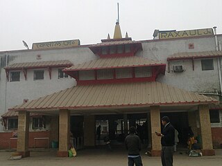
Raxaul is a sub-divisional town in the East Champaran district of the Indian state of Bihar. It is situated at the India-Nepal border with Birgunj city (Nepal). Raxaul is a major railway junction.
Lauthaha is a city and a notified area in Purvi Champaran district in the Indian state of Bihar.
Motipur is a town and a notified area in Muzaffarpur district. It is located 14 kilometres south of Mehsi in the Indian state of Bihar. In 2021, Motipur Nagar Panchayat was upgraded to Nagar Parishad.
Narkatiaganj is a town and a notified area in West Champaran district in the Indian state of Bihar. It is a part of Tirhut Division, and situated 280 kilometres (170 mi) northwest of capital of the state, Patna.

Sugauli is a city and a notified area in East Champaran district in the Indian state of Bihar. It is the setting for Rudyard Kipling's story "Rikki-Tikki-Tavi", and the place where a treaty was signed with Nepal in 1816.
Chakia is a town and a subdivision in East Champaran district in the Indian state of Bihar. Chakia is a sub division of East Champaran district. It is located approximately 48 Kilometres northwest of Muzaffarpur. 32 kilometers southeast of its District headquarters Motihari.

Mehsi is a CD Block and Mehsi Nagar Panchayat City and a municipality in the Purvi Champaran district in the Indian state of Bihar. It is a part of the Tirhut Division. The town is the entry point of the Purvi Champaran district. There are many smaller factories manufacturing buttons for the clothing Industry, although most of the population depends upon commercial business and Business agriculture.
Chamua is a village located in West Champaran district of Bihar state, India. The village is 7 km from Narkatiaganj and Ramnagar (Harinagar). Chamua has its own Gram Panchayat, a primary school, a high school, a primary health centre. As per the Census of India 2011, Chamua has a population of 2494 persons with 1281 male and 1213 female.
Champapur is a village in Narkatiaganj subdivision region West Champaran district in the Indian state of Bihar. The village is15 km away from Narkatiaganj, 36 km from its district West Champaran and 230 km from its state capital city Patna.
Sagauli Junction railway station is a junction railway station in East Champaran district, Bihar. Its code is SGL. It is on the Delhi–Muzaffarpur–Gorakhpur main line

Naya gaon railway station,, is a railway station in Sonpur Block in Saran district in the Indian state of Bihar. One siding Railway line from Rail Wheel Plant, Bela plant site to Nayagaon station is under construction.

Bettiah railway station (code BTH), is a railway station in India in the Samastipur Division of East Central Railway. Bettiah railway station is located in Bettiah city, administrative headquarters of the West Champaran district in the state of Bihar. Bettiah station is well connected to Patna, Muzaffarpur, Hajipur, Delhi, Mumbai, Kolkata, Howrah, Kanpur, Guwahati, Surat, Lucknow, Amritsar, Ranchi, and other major cities. It is also the originating station for many express trains.
Bagaha railway station is a railway station on Muzaffarpur–Gorakhpur main line under the Samastipur railway division of East Central Railway zone. This is situated beside State Highway 64 at Naraipur, Bagaha in West Champaran district of the Indian state of Bihar.
Prajapati Halt railway station is a railway station on Muzaffarpur–Gorakhpur main line under the Samastipur railway division of East Central Railway zone. This is situated beside Bagaha Dhala Road at Chawani, Bettiah in West Champaran district of the Indian state of Bihar.
Semra railway station is a railway station on Muzaffarpur–Gorakhpur main line under the Samastipur railway division of East Central Railway zone. This is situated at Chhapra Bahas, Bagaha Dhala in East Champaran district of the Indian state of Bihar.
Thakraha, or Thakrahan, is a town and the seat of government of Thakrahan Block, Pashchim Champaran, Bihar, India. It is located near the state border with Uttar Pradesh, about 25 kilometres west of the district seat Bettiah. In the year 2011, the town has a total population of 35,734.
Nautan Dube is a village in Pashchim Champaran district in the Indian state of Bihar. It is located near the state border with Uttar Pradesh, about 11 kilometres southwest of the district headquarter Bettiah. It had a population of 31,190 according to the 2011 census.
