
Pattambi is a town taluk and municipality in the Palakkad district of the state of Kerala, India. It is also the administrative headquarters of the Pattambi Taluk. Pattambi is located along the banks of Bharathappuzha river. A Mini Civil Station also functions here to provide government related services.
Daudnagar is a town and the subdivisional headquarter of Daudnagar Subdivision in Aurangabad district in the state of Bihar, India under the Magadh division. Until 1991, there was only one Subdivision in the Aurangabad district: Aurangabad Sadar. On 31 March 1991, one other subdivision, Daudnagar, was created. Daudnagar is a 200-year-old historical city and its living proof is Daudnagar has an old historical fort situated on the eastern bank of the Son River. National Highway NH139 which connects Jharkhand's Palamu district to Patna, passes through the town.
Dibiyapur is a municipality-based city in Auraiya district in the most populous state of Uttar Pradesh in India. It is situated on State Highway 21. It is linked to Phaphund railway station on Kanpur–Delhi section of Howrah–Delhi main line and Howrah–Gaya–Delhi line which is operated by North Central Railway. The district administrative headquarter of the city is Auraiya. The city is situated between Agra and Kanpur and is famous for industries and education. Lower Ganga Canal passes through mid of the city.
Kharupetia is a town and a municipal board in Darrang district in the Indian state of Assam. Kharupetia is a fast-developing commercial town in Mangaldoi Sub-Division under Darrang District. It is about 17 km from Mangaldoi, the District headquarters and 87 km from Guwahati, the gateway of North East region. It is connected by National Highway 15.
Ratwara a village in Sitamarhi district of Bihar, India also known as Vishnupur Ratwara or Bishunpur Ratwara.
Kulasekharam is a town located in the district of Kanyakumari, Tamil Nadu, India. It is one of the most important business centres in the district, after Marthandam.
Salepur is a town in the district of Cuttack. It is situated near the bank of holy river Chitrotpala mother of Ganga, 25 km from the city of Cuttack and 55 km from the state capital Bhubaneswar.
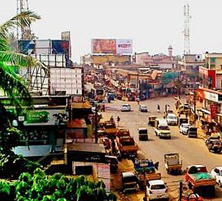
Pathirippala is a town in Palakkad district, Kerala, India, between Ottappalam and Palakkad on the Palakkad–Ponnani state highway SH 23.
Puthanathani is a census town in Malappuram district in the state of Kerala, India. The town lies on the National Highway 66 (India), between Kottakkal and Valanchery. Roads to Vailathur and Thirunavaya also can be seen in Puthanathani.
Walidpur is a village in Meerut district in the Indian state of Uttar Pradesh.

Govindpur Jhakhraha is a small village in the historical Vaishali district of Bihar, India. It is located across NH 322 at 13 km east of district headquarters Hajipur. The village falls under Bakarpur Panchayat of Rajapakar community development block. The population of the village is approximately 1800. Bajjika is the main dialect but Hindi and Urdu is the medium of study. English is understood and spoken by a few elites of the village.
Manikpur is a small town and a Block and a Sub division in Bongaigaon district in the Indian state of Assam. Manikpur is 33 km far from its district main city Bongaigaon. It is 155 km far from its state capital Dispur. The majority of the people in Manikpur belong to the Koch community of Austro-Mongoloid ethnicity. With the passage of time, Assamese caste Hindus and Muslims have started settling in Manikpur. Politically, the area is part of Abhayapuri North.
Gisara urf Gidhsara is an area in the Sitamarhi district of the state of Bihar, in north-east India. Due to frequent flooding, Gisara has significant alluvial deposits. Because of its geography, the area is rich in agriculture. The main market areas are around Gisara Bazar and Gisara Chauraha.
Manik Chowk is a village in the Indian state of Bihar.
Hutup is a small village in Ormanjhi tehsil, Ranchi district, Jharkhand, India. It is one of 91 villages in Ormanjhi Block along with villages like Koilari and Karma. The village is mostly known for its famous zamindar or king 'Thakur Tilak Dhari Singh. zamindar of seven nearby villages.He was very much praised by the villagers. He played a very great role. And donated most of the land to poor farmers. He donated many lands for temples,mosques,Schools and Hospital. he ruled the village with honour and pride. At present His grandsons(Thakur Dhruvpratap singh,Thakur Govind Singh,Thakur Aditya Singh And Thakur Sarju Singh) are also contributing and raising the name of The Great Tilakdhari Singh. Its nearest railway station is in Ranchi, accessible via National Highway 33.

Chhatwan is a village in Keotiranway Tehsil, Darbhanga District, Bihar, India.
Ukhrid, an alternative named Ukharid, is a village and a gram panchayat, located in Khandaghosh CD block in Bardhaman Sadar South subdivision of Purba Bardhaman district in the state of West Bengal, India.
Choraut is a block in Sitamarhi district in the Indian state of Bihar.
Kurumgram is an old village located in Nalhati I CD Block in Rampurhat subdivision of Birbhum district in West Bengal State of India.
Pokhraira is a village in Bokhra block of Sitamarhi District in Bihar state of India. It is surrounded by three main cities of Bihar, which are Muzaffarpur, Darbhanga and Sitamarhi. Pokhraira is 27 km distance from district main city Sitamarhi and 97 km distance from state capital Patna.
