Rampur Jetha

Last updated

Rampurwa
Rampurwa village
village
Budhi Gandak.jpg
India Bihar location map.svg
Red pog.svg
Rampurwa
Location in Mehsi, Bihar, India
India location map.svg
Red pog.svg
Rampurwa
Rampurwa (India)
Coordinates: 26°22′08″N85°06′15″E / 26.36889°N 85.10417°E / 26.36889; 85.10417
CountryFlag of India.svg  India
State Bihar
Division Tirhut
District East Champaran
Block Mehsi
Elevation
51 m (167 ft)
Languages
  Official Bhojpuri, Hindi
Time zone UTC+5:30 (IST)
PIN
845426
Telephone code+91-6257
ISO 3166 code IN-BR
Nearest city Mehsi
Lok Sabha constituencyMotihari
Vidhan Sabha constituency Pipra, Purvi Champaran (Vidhan Sabha constituency)
Avg. summer temperature38 °C (100 °F)
Avg. winter temperature12 °C (54 °F)

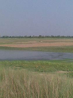
Rampurwa is a village situated in Mehsi, East Champaran District in the Indian state of Bihar. The village is commonly known as Rampurwa among the localities. It lies in the Mirjapur Panchayat region. It is situated at the bank of river Burhi Gandak River on whose bank the village has flourished. It is well connected by road and railways. The nearest city Kaswa Mehsi in Mehsi, which is 2 km from the village. The nearest railway station is Mehsi railway station, which is around 5 km from the village.

Contents

The village is located 2 km east of Mehsi police station. Mehsi is an entry point of East Champaran if travelling from Patna, Muzaffarpur to Raxaul, connected both by railway and roadway. This small community has a number of places of interest at the east side of railway station. These include Mirza Halim Shah mosque, dargah, a very old library 'Nagrik Pustakalaya', an old high school (Tirhut Vidyalaya) of the English period, orchards of lichi and mangoes and other places of interest. There are many button factories, a small scale industry, although most of the people depend upon agriculture and commerce. Mehsi was the birthplace of the writer and intellectual, Rajkamal Chaudhary. The last sentence about the birthplace of Rajkamal Chaudhary is not at Mehsi of District East Champaran, but it is at Saharsa district of Bihar. [1]

Location

The village is located 1 km east of Mehsi Police-station. The nearest highway is NH-28 which is 1.5 km west of village.[ citation needed ]

River

The village is situated on the bank of a Himalayan foothills Someshwer Range originated, perennial river Budhi Gandak on which bank the village has grown up and flourished.

Economy

The basic lively-hood is agriculture and cottage industry. Rampurwa is one of major producer of lichi in Mehsi. There are many button factories, a small scale industry, although most of the people depend upon agriculture and commerce.

Demographics

As of the 2001 India census the total population of the village is 375. The literacy rate is 65.61%. The female literacy rate is 47.1%. The male literacy rate is 78.71%. [2]

Climate

The summer, April–July is extremely hot and humid (28/40 deg C,90% Max.) and winter is cold, around 06/20 deg C. [2]

Notes

Related Research Articles

<span class="mw-page-title-main">Sheohar district</span> District of Bihar in India

Sheohar is an administrative district in the state of Bihar in India. The district headquarters are located at Sheohar, and the district is a part of Tirhut Division. This district was carved out of Sitamarhi district in 1994 due to the extreme efforts of Raghunath Jha, former Union Minister. Eminent Hindi Novelist, Dr. Bhagwati Sharan Mishra was the first District magistrate of Sheohar. Sivas used to have a guest house in the Mehsi town of his time, which is still located in the name of Raja Bazar in East Champaran.The district occupies an area of 443 km2 and has a population of 656,246. Sheohar is known for its greenery and cleanliness. Cadamba and teak are the principal trees of this district. Nilgai or blue bull is the regional animal of this area.

<span class="mw-page-title-main">East Champaran district</span> District of Bihar in India

East Champaran is an administrative district in the state of Bihar in India.The district headquarters are located at Motihari. Prior to 1st Dec 1977, there was a single district called "Champaran". On 1 December 1977, the district was divided into 2 parts East Champaran and West Champaran. In early days the land of East Chamapran was ruled by different kingdoms as Videha, Sunga, Kanvas. It is also believed that Champaran used to be a major part of King Janak's empire. Mahatma Gandhi Started his famous Satyagraha movement from here. Proper district Entry Point Mangrahi, Bakhari in Mehsi Champaran

Bagaha is a city and a municipality in the district of Pashchim Champaran in the state of Bihar, India. It is a subdivision of Pashchim Champaran district and is a Police District. It is located around 64 kilometres (40 mi) northwest of its district headquarters Bettiah. It is 294 km (183 mi) away from Bihar's state capital Patna.

Chanpatia is a city Nagar Panchayat situated on the bank of the Burhi Gandak River is the administrative headquarter of Chanpatia block in Paschim Champaran district near the Indo-Nepal border, 18 km from District headquarter Bettiah, 242 km north-west of capital city Patna in the state of Bihar, India. Chanpatia is famous for tasty Marcha Ka chura, Basmati rice and the famous Handi kabab.

<span class="mw-page-title-main">Raxaul</span> Town in Bihar, India

Raxaul is a sub-divisional town in the East Champaran district of the Indian state of Bihar. It is situated at the India-Nepal border with Birgunj city (Nepal). Raxaul is a major railway junction.

Lalganj is an important town and Nearest City, (60 kilometres Morden Old City Mehsi), and river port situated in Vaishali district, Bihar.

Motipur is a town and a notified area in Muzaffarpur district. It is located 14 kilometres south of Mehsi in the Indian state of Bihar. In 2021, Motipur Nagar Panchayat was upgraded to Nagar Parishad.

Rosera is a town (subdivision) on the bank of River Budhi Gandak. It is a municipality in Samastipur district in the Indian state of Bihar. Rosera block consists of 48 villages. Rosera is well connected by the rest of the country through railway or road network. Rosera is connected to Begusarai district via SH-55 and Darbhanga district via SH-88 and it's approx 120km from Capital Patna.

Chakia is a town and a subdivision in East Champaran district in the Indian state of Bihar. Chakia is a sub division of East Champaran district. It is located approximately 48 Kilometres northwest of Muzaffarpur. 32 kilometers southeast of its District headquarters Motihari.

<span class="mw-page-title-main">Mehsi</span> City in Bihar, India

Mehsi is a High Deployment City and a municipality in the Purvi Champaran district in the Indian state of Bihar. It is a part of the Tirhut Division. The town is the entry point of the Purvi Champaran district. There are many smaller factories manufacturing buttons for the clothing Industry, although most of the population depends upon commercial business and Business agriculture.

Bhawanipur is near Areraj in the Indian state of Bihar. Bhawanipur is situated at the Bank of River Budhi-Gandak which falls in Ganga Patna. Bhawanipur is situated at a distance of about 40 km from Motihari, the district headquarters of East Champaran district. The National Highway NH 28 provides the closest route to Motihari. Bhawanipur falls under the jurisdiction of Sangrampur Police Station. Bhawani Pur village has two Panchayats: South Bhawani Pur and North Bhawani Pur. The famous Someshwar Shiv Madir, is located at Areraj which is at a 15-minute drive from Bhawanipur. Bhawani Pur belongs to the Kesaria Assembly and the Purvi Champaran Lok Sabha of Bihar.

Pakri pakohi is a village in Muzaffarpur district of Bihar, India. This village is about 5 km west of Bhagwanpur and is located under the Marwan block. The village is connected with a road from Muzaffarpur to Rewa called Rewa road. The nearest railway station is Muzaffarpur and the nearest airport is Muzaffarpur Airport.

Surkhi is a small village in Obra Block in Aurangabad District in Bihar, India. Surkhi is under Sonahuli Panchayat.

Jihuli is a village in the East Champaran district of Bihar, India.

Sarauti is the district headquarters of the Arwal district in the Indian state of Bihar.

Katarmala is one of the Villages of Begusarai District in Bihar, India. Katarmala South is one of the eight Panchayat of Dandari Block in Ballia Subdivision Katarmala village is the administrative headquarters of Katarmala South Panchayati raj. The district lies on the souththern bank of the Budhi Gandak river.

Tengraha is a village in Minapur Block in Muzaffarpur district of Bihar, India. It belongs to Tirhut Division. It is located 26 km north of the Muzaffarpur district headquarters, 8 km from Minapur, and 91 km from the state capital, Patna. It is surrounded by Gandak and Bagmati rivers. Most of the people in this village are farmers. This village, as well as the rest of Muzaffarpur district, is famous for its Lichee trees, which grow litchis fruit. Tengrari has a small shopping market. Balua Bazar is near Tengrari, which has a shopping market and Rishabh Vastralaya.

Pakaridayal is a subdivision in East Champaran district in Bihar, India. It has a PIN Code as: 845428. It is 130 km from Patna. One can reach here by road mainly NH-28 towards Motihari. There are several towns and villages like Hajipur, Muzaffarpur, Kaanti, Mehsi, Motipur, Chakiya and Chorma in between Patna and Pakaridayal. This village is a Nagar Panchayat. It is situated on the bank of Budhi Gandak river, which origins from Nepal.

Khairwa is a village in West Champaran district in the Indian state of Bihar. The village is situated on the banks of the river Bhudi Gandak, which is a tributary of the river Gandak.

<span class="mw-page-title-main">Mehsi railway station</span> Railway station in Bihar, India

The Mehsi railway station is a railway station on Muzaffarpur–Gorakhpur main line under the Samastipur railway division of East Central Railway zone. It is located in the Indian State of Bihar district East Champaran City of Mehsi.

References

  1. "Mehsi in India", India9.com, 30 June 2005, web: i9-Mehsi.
  2. 1 2 3 . "all about bihar", www.allaboutbihar.com i8-Rampurwa Archived 2012-03-26 at the Wayback Machine .