
Hugli-Chuchura or Hooghly-Chinsurah is a city and a municipality of Hooghly district in the Indian state of West Bengal. It lies on the bank of Hooghly River, 35 km north of Kolkata. It is located in the district of Hooghly and is home to the district headquarters. Chuchura houses the Commissioner of the Burdwan Range. It is a part of the area covered by Kolkata Metropolitan Development Authority (KMDA). The District Court building of Chinsurah is the longest building in West Bengal.

Madhepura district is one of the thirty-eight districts of Bihar state, India, and Madhepura town is the administrative headquarters of this district. Madhepura district is a part of Kosi division.
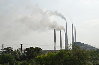
Kolaghat (কোলাঘাট) is a census town in Kolaghat CD Block, Tamluk subdivision of the Purba Medinipur district in the state of West Bengal, India.
Giridih is a community development block that forms an administrative division in the Giridih Sadar subdivision of the Giridih district in the Indian state of Jharkhand.

Dalkhola is a city and a municipality of Uttar Dinajpur district in the state of West Bengal, India.

Domjur is a census town in Domjur CD Block of Howrah Sadar subdivision in Howrah district in the Indian state of West Bengal. It is a part of Kolkata Urban Agglomeration.It is famous for its gold jewellery industries.

Khirpai, also known as Kshirpai, is a city and a municipality in the Ghatal subdivision of the Paschim Medinipur district in the state of West Bengal, India. The city is situated between Ghatal and Chandrakona, near the banks of the rivers Shilabati and Kethai, and is one of the oldest municipalities in India. Khirpai is also famous for its ‘Babarsha’, a special type of sweetmeat, which is not available elsewhere.

Mainaguri is a town and a municipality in the Jalpaiguri Sadar subdivision of the Jalpaiguri district in the state of West Bengal, India. It is known as the "Gateway of the Dooars" and is a regionally significant tourist destination for "Jalpesh Temple" of Lord Shiva and nearby Gorumara National Park.
Guptipara is a census town in Balagarh, a community development block that forms an administrative division in the Sadar subdivision of the Hooghly district in the Indian state of West Bengal.

Gidhaur is a small town in the Jamui District of Bihar. In the early-modern period, it was the centre of the Gidhaur chieftaincy.
Raghopur is a community development block in Vaishali district of Bihar. Situated between two streams of the Ganges river, it is a river island. It is connected to Patna by Pipa pul. Ancient name of Raghopur is Kotigram.
Desari is a community development block in Vaishali district in the Indian state of Bihar. The main Post office is Desari Desari is one of the 16 blocks of Vaishali. There are 39 villages in Desari block.
Ismailpur (Harauli) is a village in Vaishali district of Bihar state in India.

Maliara is a village in Barjora in Bankura district of West Bengal State, India. It belongs to Burdwan Division.
Gangadharpur is a census town in the Chanditala I CD Block located in the Srirampore subdivision of the Hooghly district in the state of West Bengal, India.
Sadar, Hazaribagh is a community development block that forms an administrative division in the Hazaribagh Sadar subdivision of the Hazaribagh district in the Indian state of Jharkhand.
Barkagaon is a community development block that forms an administrative division in the Hazaribagh Sadar subdivision of the Hazaribagh district in the Indian state of Jharkhand.
Iswarchandrapur is a village in Hanspukuria Gram Panchayat in Tehatta II CD Block in Tehatta subdivision of Nadia district. It is situated beside the river Jalangi.
Kurumgram is an old village located in Nalhati I CD Block in Rampurhat subdivision of Birbhum district in West Bengal State of India.
Sattari is a village in Malda district of the state of West Bengal, India. Sattari is known for producing mango (aam) supply, lace (gamchha), and carpet work. It is the headquarters of Binodpur Gram Panchayat on which it is represented by 6 of the 13 seats.

