Kaimur district

Last updated

Kaimur district
Mundeshwari Devi.jpg
Durgavati river mountain view.jpg
Bihar district location map Kaimur.svg
Location of Kaimur district in Bihar
CountryIndia
State Bihar
Administrative Division Patna Division
Headquarters Bhabua
Area
  Total3,362 km2 (1,298 sq mi)
Population
 (2011)
  Total1,626,384
Time zone UTC+5:30 (IST)
PIN
8211xx (Kaimur) [1]
ISO 3166 code IN-BR
Lok Sabha Sasaram
Website http://www.kaimur.bih.nic.in/

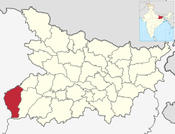
Kaimur district is one of the 38 districts of Bihar, India. The district headquarters are at Bhabua. Before 1991, it was part of Rohtas District. Till 1764 the region (Kaimur district) was a part of Ghazipur District and was a part of Kamsaar Raj and later it was a part of Chainpur Estate till 1837.

Contents

The district occupies an area of 3363 km² and has a population of 1,626,384 (as of 2011) with the rank of 307th in the country. The district has a Literacy rate of 69.34% (392nd in the country). Kaimur district is a part of Patna division. It is the Western-southern district of Bihar, Western-southern point of Bihar called Chand is situated on the Bhabua–Chandauli road. The district has 18 colleges, 58 high schools, 146 middle schools, and 763 primary schools. The district has a total of 1699 villages. The district also has 120 post offices and 151 panchayat, and is well connected with NH-2(Grand trunk road). Which is accomplished by Bhabhua Road (BBU) railway station it is the main route which connects Sealdah to Mumbai via Gaya junction.

The most spoken languages are Hindi and Bhojpuri. Due to its close proximity to eastern Uttar Pradesh, people here have Purvanchali tinge in their language.

History

Kaimur district was established on 17 March 1991 when it was split off from Rohtas district. It was called Bhabua district until 1994, when it was renamed to its current name. [2]

The earliest evidence of human habitation in the district consists of rock paintings in the Lehda forest that date to around 20,000 years ago. In June 2012, erotic Pala sculptures were excavated in the village of Baidyanath. [3]

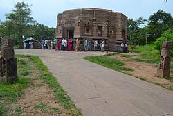
It is currently a part of the Red Corridor. [4] In the other side it is associated with belief of Hindus it is Penitential of Atri (Sanskrit: अत्रि) or Attri Rishi & one of the oldest temple in India of Ma Mundeswari which is the part of attraction of tourism.

Geography

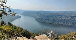
Kaimur district occupies an area of 3,362 square kilometres (1,298 sq mi), [5] comparatively equivalent to Russia's Vaygach Island. [6] Geographically, the district can be divided into two parts viz. (i) Hilly area and (ii) Plain area. The hilly area is Kaimur plateau (also known as Rohtas plateau). The plain area on the western side is flanked by the rivers Karmanasa and the Durgavati. The Kudra river lies on it eastern side. The district of Buxar of Bihar State and the district of Ghazipur of U.P. State bound it on the North. On the south is the district of Rohtas of Bihar State and on the West is the district of Chandauli and Mirzapur of the U.P. State. On the East is district of Rohtas of Bihar State. [7]

Kaimur district has a large forest cover, measuring roughly 106,300 hectares which contains the Kaimur Wildlife Sanctuary, home to tigers, leopards and chinkaras. Waterfalls like Karkat Waterfall and Telhar are present here.

Politics

DistrictNo.ConstituencyNamePartyAllianceRemarks
Kaimur 203 Ramgarh Sudhakar Singh RJD MGB
204 Mohania Sangita Kumari BJP NDA Switched from RJD to BJP
205 Bhabua Bharat Bind RJD MGB
206 Chainpur Mohd Zama Khan JD(U) NDA Switched from BSP to JD(U) [8]

Economy

Agriculture is the main component of the economy in the district. Rice, wheat, telhan, dalhan and maize are the main crops. Industries located in the district include Vanaspati Oil Ltd., ACC Limited and the Power Grid Corporation of India's high voltage direct current (HVDC) grid station at Pusauli.

In 2006 the named Kaimur one of the country's 250 most backward districts (out of a total of 640). [9] It is one of the 36 districts in Bihar currently receiving funds from the Backward Regions Grant Fund Programme (BRGF).The Mudeshwari Mata Temple have a very huge potential to be developed into a religious tourism hub. [9]

Divisions

Kaimur district is divided into 11 community development blocks, grouped together into 2 subdivisions, based at Bhabua and Mohania: [10]

Villages

Transport

Road

National Highway 19 (G.T. Road) crosses through Mohania Town, Pusauli and Kudra.

National Highway 319 (India) originates from Mohania and connects with the capital Patna via Arrah. Apart from these, there are also a few state highways in the city. Mohania is connected to Bauxar via Ramgarh from the south and with Bhabua (district capital, Adhaura, Bhagwanpur) from the south. The State Highway 14 connects Bhabua to Mohania.

Bhabua Road Railway Station is (Mohania Town) situated on Gaya–Mughalsarai section of Grand Chord Railway line. Bhabua (the district headquarters) is 14 km southward from the Bhabua Road railway station.

The famous Mundeshawari Devi Temple (the 'oldest functional' temple of world) is about 10 km south to Bhabua and about 25 km south to the railway station. If someone wants to visit the temple then he should arrive at Bhabua Road station first then he may take a direct bus to Mundeshawari Devi temple or may first take bus to Bhabua and then an auto/tempo to the temple.

The nearest airport is Lal Bahadur Shastri International Airport (VNS) (Babatpur, Varanasi).

Demographics

Historical population
YearPop.±% p.a.
1901317,384    
1911301,646−0.51%
1921293,753−0.26%
1931322,778+0.95%
1941377,028+1.57%
1951435,283+1.45%
1961526,251+1.92%
1971656,905+2.24%
1981783,045+1.77%
1991972,949+2.20%
20011,275,579+2.75%
20111,626,384+2.46%
source: [12]
Religions in Kaimur district (2011) [13]
ReligionPercent
Hinduism
89.54%
Islam
9.55%
Buddhism
0.47%
Other or not stated
0.44%

According to the 2011 census Kaimur district has a population of 1,626,384, [14] roughly equal to the nation of Guinea-Bissau [15] or the US state of Idaho. [16] This gives it a ranking of 307th in India (out of a total of 640). [14] The district has a population density of 488 inhabitants per square kilometre (1,260/sq mi) . [14] Its population growth rate over the decade 2001–2011 was 27.54%. [14] Kaimur has a sex ratio of 919 females for every 1000 males, [14] and a literacy rate of 71.01%. 4.03% of the population lives in urban areas. Scheduled Castes and Scheduled Tribes make up 22.69% and 3.57% of the population respectively. [14]

Languages

Languages in Kaimur district (2011) [17]

   Bhojpuri (90.55%)
   Hindi (7.11%)
   Urdu (2.13%)
  Others (0.21%)

At the time of the 2011 Census of India, 90.55% of the population in the district spoke Bhojpuri, 7.11% Hindi and 2.13% Urdu as their first language. [17]

See also

Related Research Articles

<span class="mw-page-title-main">Sasaram</span> City in Bihar, India

Sasaram, also spelled as Sahasram, is a historical city and a municipal corporation region in the Rohtas district of Bihar state in eastern India.

Bhabua is main city of Kaimur district in the state of Bihar, India. Bhabua is known for the famous historical temple Mundeshwari Temple and the Kaimur Range of hills. It is located 84 km from Varanasi.

<span class="mw-page-title-main">Nawada district</span> District of Bihar in India

Nawada district is one of the thirty-eight districts of the Indian state of Bihar. Nawada is its administrative headquarters. The district is the easternmost district of the Magadh division, one of the nine administrative divisions of Bihar. The area of the modern district was historically part of the Magadha, Shunga and Gupta empires. Koderma and Giridih districts of the state of Jharkhand lie on the southern border of the district; it also shares borders with the Gaya, Nalanda, Sheikhpura, and Jamui districts of Bihar.

<span class="mw-page-title-main">Rohtas district</span> District of Bihar in India

Rohtas District is one of the thirty-eight districts of Bihar state, India. It came into existence when Shahabad District was bifurcated into Bhojpur & Rohtas in 1972. Administrative headquarter of the district is Sasaram. Rohtas district has the highest literacy in Bihar. The literacy rate of Rohtas district which is 73.37% as per 2011 census is highest among all 38 districts of Bihar.

Shahabad district or Arrah district, headquartered at Arrah was a Bhojpuri speaking district in western Bihar, India, making the western border of Bihar with Uttar Pradesh. In 1972, the district was split into two districts: Bhojpur and Rohtas. Kaimur District was carved out from Rohtas in 1991 and Buxar District from Bhojpur in 1992.

Mohania is a city and corresponding community development block in Kaimur district of Bihar, India. It serves as headquarters for the Mohania sub-division in Kaimur district. It is 17 km (11 mi) by road north of the city of Bhabua, at the intersection of National Highway 19, NH-219, and NH-319. The bank of the Durgavati River is just to the south of Mohania. The total block population was 218,479, in 32,198 households.

Kudra, formerly known as Jahanabad, is a town and corresponding community development block in Kaimur district in the state of Bihar, India. It is the third largest town in Kaimur district. It is situated about 18 km from District Headquarter Bhabua. As of 2011, the population of Kudra was 30986. The railway station in Kudra is connected to all major railway routes.

Chandesh is large village in Nuaon block of Kaimur of Bihar in India. It belongs to the Patna division. It is located 48 km north of district headquarters Bhabua and 172 km from the state capital Patna. It has a population of 34,243 in 395 households. There are numerous general stores, medical, textile, electronic, grocery, and sweet shops. Almost all household things are available in the village bazaar. The village is administered by a panchayat. As of 2022, Jai Prakash Rai is the mukhia of this gram panchayat. The village has recently been awarded an elevated status of "Adarsh Gram" under Pradhan Mantri Adarsh Gram Yojana.

Bharkhar is a village near Mohania in the state of Bihar, India.

<span class="mw-page-title-main">Bhabua Road railway station</span> Railway station in the Indian state of Bihar

Bhabhua Road Junction is a railway station on the Grand Chord line on the outskirts of Mohania, 10.25 miles (16.50 km) from Bhabua in the Indian state of Bihar. It is also on the route of the Grand Trunk Road. It has five platforms. It is a B Grade station in Kaimur district recognised by Railway of India. As of 2022, over 70+ trains from various starting stations pass through the station daily.

Kaimur Wildlife Sanctuary is situated in Kaimur District and Rohtas District of Bihar. It is the largest sanctuary in the state and extended in area of 1,504.96 km2 (581.07 sq mi) in plateaued landscape of Kaimur Range. It was established in 1979. The major forest types are Tropical Dry Mixed Deciduous, Dry Sal Forests, Boswellia Forests and Dry Bamboo Brakes. It is home to rare and endangered flora and fauna. Rohtasgarh Fort and Shergarh Fort are also located in these forests. It also has numerous Megaliths, Rock painting of prehistoric age and stone inscription from a bygone era. The Government of Bihar has planned to developed it into Tiger Reserve.

<span class="mw-page-title-main">Mahabirganj</span> Village in Bihar, India

Mahabirganj is a village with a population of 225 lies in north east corner of Parsathua market in Rohtas district in the Indian state of Bihar. It is 41 km from the district headquarters Sasaram and 22 km from Kudra and the same distance from Mohania, the location of Bhabua Road railway station. This village is situated around 0.5 km north of National Highway 30. The nearest market, Parsathua, is 1.25 km from here, the nearest school colleges are 1.25 km away and the nearest hospital is 11 km away. An electric distribution center is the main landmark of this village. There is no water supply and the village can be reached by bus or minibus. This village is still not connected with National High Way 30 while its distance from this High Way is hardly 500 m. No any government plans has facilitated this villages. There is quite lack of ground facilities in this village like primary school, pukka lanes, drainage systems, hospital, and play ground. Villagers have tried many times for these facilities but no use. Political Parties members come here in time of election after that no one is to help these villages. The main lifeline are means of income is cultivation and animal husbandry. Label of education is average here.

National Highway 219, commonly referred to as NH 219 is a national highway in India. It is a spur road of National Highway 19. NH-219 traverses the states of Bihar and Uttar Pradesh in India.

Mapatpur is a small village in Nuaon Tehsil in Ramgarh Block in Kaimur district of the Indian state of Bihar. It comes under the Panchayat raj political system and belongs to the Patna Division.

Durgawati is a community development block in Kaimur district in Indian state of Bihar. It is geographically located between 25° 12' 41" north latitude and 83° 31' 51" east longitude. It is located at an altitude of 76 m (249 ft) above mean sea level. Its headquarters is 30.6 km by road north of the district headquarters, Bhabua, on National Highway 19.

Karundia is a large village in the Chand block of Kaimur of Bihar in India. It belongs to the Patna Division. It is located 30 km towards west from the district headquarters of Bhabua and is located at a distance of 172 km from the state capital Patna.

Barwan Kala is a village located in the Tehsil Adhaura of Kaimur District of the state of Bihar in India. It is a rural village taking place in the list with other 128 villages. It is said that bachelors in this village has not seen a single marriage in the last 50 years, it means Barwan Kala in Bihar is witnessing singledom.

Akbarpur is a village in Rohtas block of Rohtas district, Bihar, India. Located on the bank of the Son river, a short distance east of the historic Rohtasgarh fort, Akbarpur is the headquarters of Rohtas block. As of 2011, it had a population of 9,236, in 1,491 households. Akbarpur covers 333 hectares and 6.73 km2.

Chainpuris a Town and corresponding community development block in Kaimur district of Bihar, India. It is located 11km west of Bhabua, the district headquarters of kaimur district .As of 2011, the village population was 11,306, in 1,653 households. The block population was 187,692, in 30,189 households. The main village Chainpur was also before known as Malikpur on the name of zamindar Malik Khan one of the descendants from the family of Bhabua. Chainpur was established in early 1600s. Chainpur was the capital of Chainpur Estate.

Adhaura is a village and corresponding community development block in Kaimur district of Bihar, India. As of 2011, its population was 2,961, in 550 households. The total block population was 57,100, in 9,857 households. It is the least populated block in Kaimur district.

References

  1. Kaimur
  2. "Census of India 2011: Bihar District Census Handbook – Kaimur, Part A (Village and Town Directory)". Census 2011 India. pp. 22–85. Retrieved 11 January 2021.
  3. "Erotic sculptures of Pala period discovered in Bihar village". The Times of India . 13 June 2012. Archived from the original on 6 May 2013.
  4. "83 districts under the Security Related Expenditure Scheme". IntelliBriefs. 11 December 2009. Archived from the original on 27 October 2011. Retrieved 17 September 2011.
  5. Srivastava, Dayawanti et al. (ed.) (2010). "States and Union Territories: Bihar: Government". India 2010: A Reference Annual (54th ed.). New Delhi, India: Additional Director General, Publications Division, Ministry of Information and Broadcasting (India), Government of India. pp. 1118–1119. ISBN   978-81-230-1617-7.{{cite book}}: |last1= has generic name (help)
  6. "Island Directory Tables: Islands by Land Area". United Nations Environment Program. 18 February 1998. Archived from the original on 1 December 2015. Retrieved 11 October 2011. Vaygach Island3,329km2
  7. "About District | District Kaimur, Government of Bihar | India" . Retrieved 30 April 2020.
  8. "BSP's lone MLA in Bihar Md Zama Khan joins ruling JD(U) after meeting with CM Nitish Kumar | Patna News - Times of India". The Times of India. Retrieved 27 February 2022.
  9. 1 2 Ministry of Panchayati Raj (8 September 2009). "A Note on the Backward Regions Grant Fund Programme" (PDF). National Institute of Rural Development. Archived from the original (PDF) on 5 April 2012. Retrieved 27 September 2011.
  10. "Subdivision & Blocks". Kaimur (Bhabua). National Informatics Centre. Retrieved 7 July 2020.
  11. "Census of India 2011: Bihar District Census Handbook - Kaimur, Part A (Village and Town Directory)". Census 2011 India. pp. 600–711. Retrieved 2 February 2021.
  12. "Table A-02 Decadal Variation in Population Since 1901: Bihar" (PDF). census.gov.in. Registrar General and Census Commissioner of India.
  13. "Table C-01 Population by Religion: Bihar". censusindia.gov.in. Registrar General and Census Commissioner of India. 2011.
  14. 1 2 3 4 5 6 "District Census Handbook: Kaimur" (PDF). Census of India . Registrar General and Census Commissioner of India. 2011.
  15. US Directorate of Intelligence. "Country Comparison:Population". Archived from the original on 27 September 2011. Retrieved 1 October 2011. Guinea-Bissau 1,596,677 July 2011 est.
  16. "2010 Resident Population Data". U. S. Census Bureau. Archived from the original on 17 August 2011. Retrieved 30 September 2011. Idaho 1,567,582
  17. 1 2 "Table C-16 Population by Mother Tongue: Bihar". censusindia.gov.in. Registrar General and Census Commissioner of India. 2011.

25°02′26″N83°36′45″E / 25.040591°N 83.612409°E / 25.040591; 83.612409