Mirzapur district

Last updated • 3 min readFrom Wikipedia, The Free Encyclopedia

Mirzapur district
Siddhanth ki Dari Fall.jpg
Siddhanath ki Dari Falls
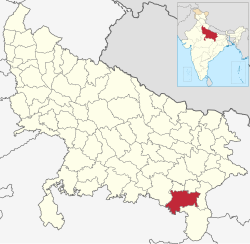
India Uttar Pradesh districts 2012 Mirzapur.svg
Location of Mirzapur district in Uttar Pradesh
CountryFlag of India.svg  India
State Uttar Pradesh
Division Mirzapur
Established1509
Headquarters Mirzapur
Tehsils 4
Government
   District Magistrate Priyanka Niranjan, IAS
   Chairman, Nagar Palika Parishad, Mirzapur Shyam Sunder Keshari
   Lok Sabha constituencies Mirzapur
   Member of Parliament, Lok Sabha Anupriya Patel (Minister of State for Commerce and Industry of India)
Area
  Total
4,521 km2 (1,746 sq mi)
Population
 (2011) [1]
  Total
2,496,970
  Density550/km2 (1,400/sq mi)
   Urban
347,567
Demographics
   Literacy 70.38%
  Sex ratio903
  Language HindiUrdu
Time zone UTC+05:30 (IST)
Vehicle registration UP-63
Average annual precipitation1043 mm
Website Official Website

Mirzapur district is one of the 75 districts in the Indian state of Uttar Pradesh. The district is bounded on the north by Bhadohi and Varanasi districts, on the east by Chandauli district, on the south by Sonbhadra district and Rewa district of Madhya Pradesh [2] and on the northwest by Prayagraj. The district occupies an area of 4521 km2. Mirzapur city is the district headquarters. Mirzapur district is a part of Mirzapur division. This district is known for the Vindhyavasini temple in Vindhyachal and several tourist attractions like waterfalls like Rajdari and Devdari [3] and dams. It consist of several Ghats where historical sculptures are still present. During the Ganges festival these Ghats are decorated with lights and earthen lamps.

Contents

It was once the largest district in Uttar Pradesh until Sonbhadra district was separated from Mirzapur in 1989.

Demographics

Historical population
YearPop.±% p.a.
1901488,998    
1911483,880−0.11%
1921483,470−0.01%
1931526,344+0.85%
1941600,806+1.33%
1951679,171+1.23%
1961803,784+1.70%
1971960,495+1.80%
19811,238,432+2.57%
19911,627,970+2.77%
20012,074,709+2.45%
20112,496,970+1.87%
source: [4]
Religions in Mirzapur district (2011) [5]
ReligionPercent
Hinduism
91.81%
Islam
7.84%
Other or not stated
0.35%

According to the 2011 census Mirzapur district has a population of 2,496,970, [1] roughly equal to the nation of Kuwait [6] or the US state of Nevada. [7] This gives it a ranking of 174th in India (out of a total of 640). [1] The district has a population density of 561 inhabitants per square kilometre (1,450/sq mi). [1] Its population growth rate over the decade 2001-2011 was 17.89%. [1] Mirzapur has a sex ratio of 900 females for every 1000 males, [1] and a literacy rate of 70.38%. 13.92% of the population lives in urban areas. Scheduled Castes and Scheduled Tribes made up 26.48% and 0.81% of the population respectively. [1] Female literacy rate here is 54%.

Languages

Languages of Mirzapur district (2011) [8]

   Hindi (80.95%)
   Bhojpuri (18.40%)
  Others (0.65%)

At the time of the 2011 Census of India, 80.95% of the population in the district spoke Hindi and 18.40% Bhojpuri as their first language. [8]

Bhojpuri language, written in both Devanagari and Kaithi scripts is widely spoken in the district. Bhojpuri language. [9] Agariya, an Austroasiatic tongue with approximately 70,000 speakers; [10] Awadhi, which has a lexical similarity of 72-91% with Hindi [11] and Bagheli, a tongue in the Eastern Hindi group are also spoken in some parts of the district bordering Awadh and Baghelkhand regions respectively.

Administrative divisions

The district consists four Tehsils. These are Mirzapur (Sadar), Chunar, Marihan and Lalganj. These four tehsils are further divided into twelve blocks.

History

Mirzapur was founded by Raja Nanner. It was formerly known as Girjapur named after Goddess Girija ( Parvati ). Current Nomenclature of Mirzapur is derived from the conjunction of the Terms Mir, Ja and Pur meaning Sea, Outcome and Town respectively. [12]

Major Tourist Places

Tourism is the core revenue generating sector of Mirzapur [13] . It has serene beautiful nature, lush green forests, wildlife sanctuaries, enchanting Hills, waterfalls and many religious sites.

Economy

In 2006 the Ministry of Panchayati Raj named Mirzapur one of the country's 250 most backward districts (out of a total of 640). [15] It is one of the 34 districts in Uttar Pradesh to have received funds from the Backward Regions Grant Fund Programme (BRGF). [15] Once tourism used to contribute to the economy but due to lack of care from government officials and local people the unmatched beauty of the places like Sirshe dam and waterfall, Dadri (Pipari) dam, Vindham waterfall, Lower Khajuri, Upper Khajuri, Lakhaniya waterfall, Siddhnath Waterfall, Kotwan-Patehara forest, Fort of Chunar and Dadri-Haliya forest has become 'the stories of past'. Once there was a time when every Sunday of rainy season used to be a fair like atmosphere for the neighbouring localities of Sirshe waterfall and Vindham waterfall due to their attraction of tourist not only from every part of the U.P. and but neighbourhood states too. The separation of the Sonebhadra largely affected the economical condition and after the closing of mills and depression in the carpet industry Mirzapur has become economically disadvantaged.

Education

Colleges

Notable people

Related Research Articles

<span class="mw-page-title-main">Bagheli language</span> Indo-Aryan language spoken in India

Bagheli or Baghelkhandi is a Central Indo-Aryan language spoken in the Baghelkhand region of central India.

<span class="mw-page-title-main">Mirzapur</span> City in Uttar Pradesh, India

Mirzapur is a city in Uttar Pradesh, India. It is known for its carpets and brassware industries, and the tradition of kajari and birha music. Straddled by the Kaimur extension of Vindhya mountains, it served as the headquarters of the Mirzapur district. In the district, Vindhya mountains meet with Indo-Gangetic Plain.

<span class="mw-page-title-main">Sonbhadra district</span> District in Uttar Pradesh, India

Sonbhadra or Sonanchal is the second largest district by area of Uttar Pradesh after Lakhimpur Kheri. The district headquarters is in the town of Robertsganj. Sonbhadra is also known as the "Energy Capital of India" for hosting multiple power plants.

Vindhyachal is a city in Mirzapur district of the Indian state of Uttar Pradesh. The city is a Hindu pilgrimage site having the temple of Vindhyavasini, who according to Markandeya Purana, had incarnated to kill the demon Mahishasura. A detailed description has been given in the 'Durga Saptashati' chapter of the Markandeya Purana. The river Ganga flows through this city. The Indian Standard Time (IST) line passes through the Vindhyachal railway station.

<span class="mw-page-title-main">Garhwa district</span> District of Jharkhand in India

Garhwa District is one of the twenty-four districts in the Indian state of Jharkhand. The Garhwa District is part of the Palamu division and has its administrative headquarters in Garhwa City.

<span class="mw-page-title-main">Prayagraj district</span> District of Uttar Pradesh in India

Prayagraj district, formerly known as Allahabad district, is the most populous district in the Indian state of Uttar Pradesh. Prayagraj city is the district headquarters of this district. The District is divided into blocks within tehsils. As of 2011, there are 20 blocks in eight tehsils. The Prayagraj division includes the districts of Pratapgarh, Fatehpur, Kaushambi and Prayagraj, with some western parts that had previously part of Allahabad District becoming part of the new Kaushambi District. The administrative divisions are Phulpur, Koraon, Meja, Sadar, Soraon, Handia, Bara, Shringverpur and Karchana.

<span class="mw-page-title-main">Chandauli district</span> District in Uttar Pradesh, India

Chandauli district is a district of Uttar Pradesh state of India, and Chandauli town is the district headquarters. Chandauli district, a part of Varanasi Division, became a separate district on 20 May 1997.

<span class="mw-page-title-main">Deoria district</span> District of Uttar Pradesh in India

Deoria district, one of the districts of eastern Uttar Pradesh, India has its headquarters located at Deoria and is a part of Gorakhpur division. It came into existence on 16 March 1946 from Gorakhpur district.

<span class="mw-page-title-main">Sant Kabir Nagar district</span> District of Uttar Pradesh in India

Sant Kabir Nagar district is one of the 75 districts of Uttar Pradesh state in northern India. Khalilabad is the district headquarters. Sant Kabir Nagar district is a part of Basti division. The total area of Sant Kabir Nagar district is 1,646 km2 (636 sq mi).

<span class="mw-page-title-main">Hamirpur district, Uttar Pradesh</span> District of Uttar Pradesh in India

Hamirpur district is one of the 75 districts of Uttar Pradesh state of India and Hamirpur town is the district headquarters. Hamirpur district is a part of Chitrakoot Division. The district occupies an area of 4,121.9 km2. The district has a population of 1,104,285. As of 2011 it is the third least populous district of Uttar Pradesh, after Mahoba and Chitrakoot. Two major rivers Yamuna and Betwa meet here. On the banks of river Betwa lies the "Coarse sand" which is exported to many parts in U.P.

<span class="mw-page-title-main">Mirzapur division</span> Administrative division of Uttar Pradesh, India

Mirzapur division, also sometimes known as Vindhyachal division, is one of the 18 administrative geographical units of the northern Indian state of Uttar Pradesh. Mirzapur city is the administrative headquarters. As of 2018, the division consists of 3 districts:-

<span class="mw-page-title-main">Varanasi district</span> District in Uttar Pradesh, India

Varanasi district is a district in the Indian state of Uttar Pradesh, with the holy city of Varanasi as the district headquarters. It is also the headquarters of the Varanasi division which contains 4 districts.

<span class="mw-page-title-main">Dindori district</span> District of Madhya Pradesh in India

Dindori District, formerly known as Ramgarh District, is a district of Madhya Pradesh state of central India. The town of Dindori is the district headquarters. The district is part of Jabalpur Division.

<span class="mw-page-title-main">Gorakhpur district</span> District of Uttar Pradesh in India

Gorakhpur district is one of the 75 districts of Uttar Pradesh state in northern India. This district is a part of the Gorakhpur division. The city of Gorakhpur, or Gorakhpur is the administrative headquarters of this district and Gorakhpur division. It borders Sant Kabir Nagar district to the west, Kushinagar and Deoria districts to the east, and Maharajganj and Azamgarh districts to the north and south.

<span class="mw-page-title-main">Kushinagar district</span> District of Uttar Pradesh in India

Kushinagar is a district of the state of Uttar Pradesh in India situated in the easternmost part of the state. It has the administrative headquarters at Ravindra Nagar Dhoos. The district is named such after the town Kushinagar, a Buddhist pilgrimage site where Gautama Buddha attained parinirvana in the 5th century BCE. Since the independence of India, Kushinagar district was a part of Deoria District and came into existence on 13 May 1994 as a separate district division. It was earlier known as Padrauna and thereafter was renamed Kushinagar on 19 June 1997.

<span class="mw-page-title-main">Robertsganj</span> City in Uttar Pradesh, India

Robertsganj, formally known as Sonbhadra, is a city and a municipal board in Sonbhadra district in the Indian state of Uttar Pradesh.

<span class="mw-page-title-main">Renukoot</span> Town in Uttar Pradesh, India

Renukoot is a town and a nagar panchayat in Sonbhadra district in the Indian state of Uttar Pradesh. It is 68 km south from the district headquarters Robertsganj.

<span class="mw-page-title-main">Languages of Uttar Pradesh</span>

Kauravi

<span class="mw-page-title-main">Bhuiyar</span> Hindu weavers caste

The Bhuiyar or Bhuyiar are a Hindu caste found in the Indian state of Uttar Pradesh. They have scheduled caste status and are also known as Bhanyar. The traditional occupation of the Bhuiyar caste is weaving but that has declined due to mechanisation.

Chunar Junction railway station is on the DDU–Kanpur section of the Howrah-New Delhi Main Line. A single electrified line goes for Chopan of the Sonbhadra district of Uttar Pradesh. It is located in Mirzapur district of the Indian state of Uttar Pradesh. It serves Chunar and the surrounding areas.

References

  1. 1 2 3 4 5 6 7 "District Census Handbook: Mirzapur" (PDF). censusindia.gov.in. Registrar General and Census Commissioner of India. 2011.
  2. Banerjee, Ruman; Srivastava, Prashant K. (2014), Srivastava, Prashant K.; Mukherjee, Saumitra; Gupta, Manika; Islam, Tanvir (eds.), "Remote Sensing Based Identification of Painted Rock Shelter Sites: Appraisal Using Advanced Wide Field Sensor, Neural Network and Field Observations", Remote Sensing Applications in Environmental Research, Cham: Springer International Publishing, pp. 195–212, doi:10.1007/978-3-319-05906-8_11, ISBN   978-3-319-05905-1 , retrieved 16 January 2025
  3. "Mirzapur".
  4. Decadal Variation In Population Since 1901
  5. "Table C-01 Population by Religion: Uttar Pradesh". censusindia.gov.in. Registrar General and Census Commissioner of India. 2011.
  6. US Directorate of Intelligence. "Country Comparison:Population". Archived from the original on 13 June 2007. Retrieved 1 October 2011. Kuwait 2,595,62
  7. "2010 Resident Population Data". U. S. Census Bureau. Archived from the original on 25 December 2010. Retrieved 30 September 2011. Nevada 2,700,551
  8. 1 2 "Table C-16 Population by Mother Tongue: Uttar Pradesh". www.censusindia.gov.in. Registrar General and Census Commissioner of India.
  9. Bhojpuri at Ethnologue (25th ed., 2022) Closed Access logo transparent.svg
  10. Agariya at Ethnologue (25th ed., 2022) Closed Access logo transparent.svg
  11. Bagheli at Ethnologue (25th ed., 2022) Closed Access logo transparent.svg
  12. "Mirzapur District Map". Maps of India. Retrieved 16 January 2025.
  13. "Mirzapur District Map". Maps of India. Retrieved 16 January 2025.
  14. "INTACH ARCHIVE : image : Zanana or Pucca Ghat, Mirzapur [MIRZ_011]". icharchive.intach.org. Retrieved 16 January 2025.
  15. 1 2 Ministry of Panchayati Raj (8 September 2009). "A Note on the Backward Regions Grant Fund Programme" (PDF). National Institute of Rural Development. Archived from the original (PDF) on 5 April 2012. Retrieved 27 September 2011.

25°09′02″N82°33′53″E / 25.150677°N 82.564807°E / 25.150677; 82.564807