Banda district, India

Last updated

Banda district
KALINZER.jpg
India Uttar Pradesh districts 2012 Banda.svg
Location of Banda district in Uttar Pradesh
CountryFlag of India.svg  India
State Uttar Pradesh
Division Chitrakoot
Headquarters Banda
Government
   Lok Sabha constituencies Banda (shared with Chitrakoot district)
Area
  Total4,413 km2 (1,704 sq mi)
Population
 (2011)
  Total1,799,410
  Density410/km2 (1,100/sq mi)
   Urban
275,755
Demographics
   Literacy 68.11 per cent
  Sex ratio863
Time zone UTC+05:30 (IST)
Website banda.nic.in

Banda district is a district of Uttar Pradesh state of India, and Banda is the district headquarters. It is a part of Chitrakoot Division.

Contents

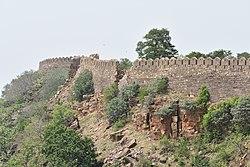
Located in historical Bundelkhand region, Banda is famous for its Shajar stone which is used for making jewellery, and the historically and architecturally significant sites Khajuraho and Kalinjar. Khajuraho is a World Heritage Site famous for its elaborately carved temples. The fortress of Kalinjar is famed for its war history and its glorious rock sculptures.

History

In 1998, the tehsils of Karwi and Mau, formerly part of Banda District, became the new Chitrakoot District. Banda was a town and district of British India, in the Allahabad division of the United Provinces. The population in 2011 was 1,799,410. It was formerly, but is no longer, a military cantonment.

Administrative divisions

There are five Tahsils namely Banda, Naraini, Baberu, Pailani and Atarra comprising eight blocks of Badokhar-khurd, Jaspura, Tindwari, Naraini, Mahua, Baberu, Bisanda and Kamasin from the present district of Banda.

There are seventeen thanas namely Kotwali City, Kotwali Dehat, Mataundh, Tindwari, Pailani, Chilla, Naraini, Atarra, Girwa, Kalinjar, Badousa, Bisanda, Baberu, Kamasin, Fatehganj, Jaspura and Marka.

Hills

The hills of the district consist of the part of the Vindhyan plateau which lies in the extreme southern portion of the tahsils Mau and Karwi (now known as the district Chitrakut). The northern flank of the Vindhyas known as Vindhyachal range, starts near the Yamuna in the extreme east of tahsil Mau. It recedes from the Yamuna in a south-westerly direction-gradually rising in elevation, although nowhere above 450 metre from the mean sea level. It leaves the district near the scared hills of Anusuiya to reappear of Godhrampur in the south-eastern part of Naraini tahsil. From this point westward to Kalinjar the hills from the border of the district.

Geography

The district largely consists of irregular uplands with outcrops of rocks intermingling with lowlands, which are frequently under water during the rainy season. The Baghein River traverses the district from south-west to north-east. Other important rivers are the Ken River in the east and the Yamuna to the north. The dominant communities of this area are of Kshatriyas, Patels, Chandrauls, Chandelas, Bundelas etc.

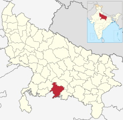
Location and boundaries

The district is located in the Chitrakutdham Division of Uttar Pradesh with its headquarter at Banda and lies between Lat. 24º 53' and 25º 55' N and Long. 80º 07' and 81º 34' E. It is bounded in the north by district of Fatehpur in the east by the district of Chitrakut in the west by the district of Hamirpur and Mahoba and in the south by Satna, Panna, and Chhatarapur the districts of adjoining Madhya Pradesh.

Agriculture

There are two main crops: Kharif and Rabi; the one between July and October and the other between November and March. The old records in the imperial gazetteer or the district gazetteer mentions cotton as one of the major crops here. But that has vanished now. The main crops grown presently are as follows:

Kharif: Paddy, jowar, bajra, til, moong, urd, arhar and sanai are the main crops taken these days. Paddy is normally taken as mono crop while others are mixed sown. 100 years ago cotton was taken as a mixed crop along with other crops in Kharif. Presently Government is pushing soybean replacing all other Kharif crops. This tendency ultimately will starve this district.[ citation needed ]

Rabi: Wheat, barley along with gram, linseed, mustard, masoor and peas are the major crops. There is a tendency for mixed cropping and regional variation in choices of the crops depending upon the geographical situation and the availability of irrigation.

Zaid: the third crops are usually taken in the river beds; that includes Kakri. Tarbooj (water melon), Kharbooja and some vegetables.

Economy

The economy is predominantly agricultural, with the main crops being paddy rice, wheat and vegetables.

In 2006 the Ministry of Panchayati Raj named Banda one of the country's 250 most backward districts (out of a total of 640). [1] It is one of the 34 districts in Uttar Pradesh currently receiving funds from the Backward Regions Grant Fund Programme (BRGF). [1]

Divisions

The district is divided into five tehsils, Banda, Naraini, Baberu, Atarra and Pailani.

Villages

Demographics

Historical population
YearPop.±% p.a.
1901406,944    
1911424,056+0.41%
1921396,194−0.68%
1931421,181+0.61%
1941486,491+1.45%
1951519,370+0.66%
1961631,666+1.98%
1971792,699+2.30%
19811,023,644+2.59%
19911,237,962+1.92%
20011,501,602+1.95%
20111,799,410+1.83%
source: [2]
Religions in Banda district (2011) [3]
ReligionPercent
Hinduism
91.00%
Islam
8.76%
Other or not stated
0.24%
Distribution of religions

According to the 2011 census Banda District has a population of 1,799,410, [4] roughly equal to the nation of The Gambia [5] or the US state of Nebraska. [6] This gives it a ranking of 265th in India (out of a total of 640). [4] The district has a population density of 404 inhabitants per square kilometre (1,050/sq mi). [4] Its population growth rate over the decade 2001–2011 was 17.06%. [4] Banda has a sex ratio of 863 females for every 1000 males, [4] and a literacy rate of 68.11%. 15.32% of the population lives in urban areas. Scheduled Castes make up 21.55% of the population. [4]

Languages

Languages of Banda district (2011) [7]

   Hindi (95.81%)
   Bundeli (1.96%)
   Urdu (1.50%)
  Others (0.73%)

At the time of the 2011 Census of India, 95.81% of the population in the district spoke Hindi, 1.96% Bundeli and 1.50% Urdu as their first language. [7] The local dialect changes from Bundeli in the south to Awadhi in the north.

Among Banda's languages are Bundeli, which has a lexical similarity of 72-91% with Hindi [8] (compared to 60% for German and English) [9] and is spoken by about 7,800,000 people in Bundelkhand. [8]

Education

Culture

Kalinjar Mahotsava: Every Year Banda District celebrates week-long Kalinjar Mahotasava to promote Kalinjar Fort's Heritage & Tourism. Kalinjar Mahotsava includes many Cultural and Social activities.

Banda MLA & MP

There are 4 assembly constituencies and 1 parliamentary constituency. [10]

MLA

NoConstituencyMLAPolitical Party
232 Tindwari Ramakesh Nishad Bhartiya Janta Party
233 Baberu Vishambhar Singh Yadav Samajwadi Party
234 Naraini Smt. Ommani Verma Bhartiya Janta Party
235 Banda Prakash Dwivedi Bhartiya Janta Party

MP

ConstituencyMPPolitical Party
Banda R.K. Singh Patel Bhartiya Janta Party

People associated with Banda


Political figures

Jamuna Prasad Bose

See also

Related Research Articles

<span class="mw-page-title-main">Banda, Uttar Pradesh</span> City in India

Banda is a city and a municipal board in Banda district in the state of Uttar Pradesh, India. Banda is divided among north, east, west and south Banda. Banda lies south of the Yamuna river in the Bundelkhand region. It is the administrative headquarters of Banda District. The town is well connected to major cities with railways and state highways. The town is near the right bank of the river Ken, 189 km south-west of Allahabad.

<span class="mw-page-title-main">Kalinjar Fort</span> Indian fort 17

Kalinjar is a fortress-city in Banda district of Uttar Pradesh, in India. It was ruled by several dynasties including the Guptas, the Vardhana dynasty, the Chandelas, Solankis of Rewa, Mughal and the Marathas.

<span class="mw-page-title-main">Baberu</span> Town in Uttar Pradesh, India

Baberu is a town and a nagar panchayat in Banda district in the state of Uttar Pradesh, India. It is one of four tehsils (subdistricts) of the Banda district.

<span class="mw-page-title-main">Jalaun district</span> District of Uttar Pradesh in India

Jalaun district is a district of Uttar Pradesh, India. The district is named after the town of Jalaun, which was the former headquarters of a Maratha governor, but the administrative headquarters of the district is at Orai.

<span class="mw-page-title-main">Kaushambi district</span> District of Uttar Pradesh in India

Kaushambi district is a district in the state of Uttar Pradesh in India. Manjhanpur is the district headquarters. The district was carved from Prayagraj district on 4 April 1997. Manauri Bajar connects Prayagraj and Kaushambi districts by railway over a bridge on SH-95. Manjhanpur is south-west of Prayagraj on the north bank of the Yamuna river, about 55 kilometres (34 mi) from the city. It is surrounded by Chitrakoot district on the south, Pratapgarh district on the north, Prayagraj district on the east and Fatehpur district on the west. Kaushambi is part of Prayagraj division. The nearest railway station, in Bharwari, connects with Delhi, Prayagraj, Kolkata, Gaya and Kanpur.kaushambi district have two river like yamuna ganga.

<span class="mw-page-title-main">Hamirpur district, Uttar Pradesh</span> District of Uttar Pradesh in India

Hamirpur district is one of the 75 districts of Uttar Pradesh state of India and Hamirpur town is the district headquarters. Hamirpur district is a part of Chitrakoot Division. The district occupies an area of 4,121.9 km2. The district has a population of 1,104,285. As of 2011 it is the third least populous district of Uttar Pradesh, after Mahoba and Chitrakoot. Two major rivers Yamuna and Betwa meet here. On the banks of river Betwa lies the "Coarse sand" which is exported to many parts in U.P.

<span class="mw-page-title-main">Mahoba district</span> District of Uttar Pradesh in India

Mahoba district is a district of the Indian state of Uttar Pradesh. Headquartered in the city of Mahoba, the district had a population of a population of 875,958 as of the 2011 Indian census and occupies 2884 km2 within the Chitrakoot division of Uttar Pradesh. As of 2011 it was the least populous district of Uttar Pradesh. Mahoba District is also known as Alha-Udal Nagari.

<span class="mw-page-title-main">Satna</span> City in Madhya Pradesh, India

Satna is a city in the Indian state of Madhya Pradesh. It serves as the headquarters of Satna district. It is 7th largest city and 8th most populous city of the state. The city is 500 km east of the state capital Bhopal. The city is distributed over a land area of 111.9 square kilometres.

<span class="mw-page-title-main">Lalitpur district, India</span> District in Uttar Pradesh, India

Lalitpur is one of the 75 districts in the northern Indian state of Uttar Pradesh. Lalitpur district is a part of Jhansi Division. Lalitpur is the main town and administrative headquarters. The district occupies an area of 5,039 km2.

<span class="mw-page-title-main">Yamunanagar district</span> District of Haryana in India

Yamunanagar district is one of the 22 districts of the Indian state of Haryana. The district came into existence on 1 November 1989 and occupies an area of 1,756 square kilometres (678 sq mi). Yamunanagar town is the district headquarters.

<span class="mw-page-title-main">Lucknow district</span> District of Uttar Pradesh in India

Lucknow district is a district located in the state of Uttar Pradesh in northern India. The city of Lucknow is the district headquarters and the district is part of Lucknow division. It is also the capital city of Uttar Pradesh. Lucknow is bounded on the east by Barabanki district, on the west by Unnao and Hardoi districts, on the south by Raebareli district and in the north by Sitapur district.

<span class="mw-page-title-main">Kulpahar</span> City in Uttar Pradesh, India

Kulpahar is a city in Mahoba district in the Indian state of Uttar Pradesh. It is a historical town in the Bundelkhand region. Before 11 Feb 1995 Kulpahar was a Tehsil of Hamirpur District. On 11 Feb 1995 Mahoba District was carved out of Hamirpur, and Kulpahar is now a part of the Mahoba District. Kulpahar is the largest Subdivision of Uttar Pradesh. Kulpahar is known for its closeness to Khajuraho and other historic places like Mahoba, Charkhari, Kalinjar Rath, Orchha, and Jhansi. This town holds relics of temples and man-made water bodies of the Chandela Dynasty

Naraini is a town and Nagar panchayat in Banda district in the Indian state of Uttar Pradesh. It is one of the four tehsils of Banda District.

<span class="mw-page-title-main">Rajapur, Uttar Pradesh</span> Town in Uttar Pradesh, India

Rajapur is a town and tehsil of Chitrakoot district in the Indian state of Uttar Pradesh. It is situated along the bank of the river Yamuna. It has the nickname "Tulsi Dhaam" after the Hindi poet Goswami Tulsidas, who is the writer of holy "Ram Charit Manas" along with many other religious books of Hindus. There is a temple devoted to Tulsidas where part of the original "Handwritten Scripture" of Ramcharitmanas is still available, although some pages may be missing. Rajapur is linked with Kaushambi district on the opposite bank of the river Yamuna.

<span class="mw-page-title-main">Chitrakoot district</span> District of Uttar Pradesh in India

Chitrakoot district is one of the districts of Uttar Pradesh state of India in the Bundelkhand region and Chitrakoot city is the district headquarters. Chitrakoot district is a part of Chitrakoot Division. The district occupies an area of 3,216 km2.The district has a population of 991,730. As of 2011 it is the second least populated district of Uttar Pradesh, after Mahoba.

<span class="mw-page-title-main">Satna district</span> District of Madhya Pradesh in India

Satna District is a district of Madhya Pradesh state in central India. The city of Satna is the district headquarters. The district has an area of 7,502 km2, and a population of 22,28,935(2011 census), 20.63% of which is urban. The district has a population density of 249 persons per km2.

Chitrakoot may refer to these places in India:

<span class="mw-page-title-main">National Highway 35 (India)</span> National highway in India

National Highway 35 is a National Highway in India. This highway runs entirely in the state Uttar Pradesh but now extension to Khajuraho in Madhya Pradesh is being done.

Badausa is a town in Uttar Pradesh, India. It comes under Chitrakoot Division, Banda District and Atarra tehsil of Uttar Pradesh.

<span class="mw-page-title-main">Mau, Chitrakoot</span> Town in Chitrakoot District UP

Mau is town and a Nagar Panchayat in Chitrakoot District of Uttar Pradesh, India. It is also a Tehsil Headquarter.

References

  1. 1 2 Ministry of Panchayati Raj (8 September 2009). "A Note on the Backward Regions Grant Fund Programme" (PDF). National Institute of Rural Development. Archived from the original (PDF) on 5 April 2012. Retrieved 27 September 2011.
  2. Decadal Variation In Population Since 1901
  3. "Table C-01 Population by Religion: Uttar Pradesh". censusindia.gov.in. Registrar General and Census Commissioner of India. 2011.
  4. 1 2 3 4 5 6 "District Census Handbook: Banda" (PDF). censusindia.gov.in. Registrar General and Census Commissioner of India. 2011.
  5. US Directorate of Intelligence. "Country Comparison:Population". Archived from the original on 13 June 2007. Retrieved 1 October 2011. Gambia, The 1,797,860 July 2011 est.
  6. "2010 Resident Population Data". U. S. Census Bureau. Archived from the original on 19 October 2013. Retrieved 30 September 2011. Nebraska 1,826,341
  7. 1 2 "Table C-16 Population by Mother Tongue: Uttar Pradesh". www.censusindia.gov.in. Registrar General and Census Commissioner of India.
  8. 1 2 M. Paul Lewis, ed. (2009). "Bagheli: A language of India". Ethnologue: Languages of the World (16th ed.). Dallas, Texas: SIL International. Retrieved 28 September 2011.
  9. M. Paul Lewis, ed. (2009). "English". Ethnologue: Languages of the World (16th ed.). Dallas, Texas: SIL International. Retrieved 28 September 2011.
  10. "List of Candidates in BANDA :BANDA". myneta.info. Retrieved 11 November 2015.

25°30′N80°30′E / 25.500°N 80.500°E / 25.500; 80.500