Muzaffarnagar district

Last updated

Muzaffarnagar district
Bada Darwaza (Front Gate) Kakrouli Muzaffarnagar.jpg
Bada Darwaza in Kakrouli village
India Uttar Pradesh districts 2012 Muzaffarnagar.svg
Location of Muzaffarnagar district in Uttar Pradesh
CountryFlag of India.svg  India
State Uttar Pradesh
Division Saharanpur
Headquarters Muzaffarnagar
Tehsils Sadar, Budhana, Jansath, Khatauli
Government
   Lok Sabha constituencies Muzaffarnagar
   Vidhan Sabha constituencies Muzaffarnagar,
Budhana,
Charthawal,
Khatauli,
Meerapur,
Purqazi
Area
  Total2,991 km2 (1,155 sq mi)
Population
 (2011)
  Total2,869,934
  Density960/km2 (2,500/sq mi)
Demographics
   Literacy 69.12 per cent [1]
  Sex ratio889/1000
Time zone UTC+05:30 (IST)
PIN
251 3xx
Vehicle registration UP-12
Major highways
NH334-IN.svg NH 334
NH709AD-IN.svg NH 709AD
SH59, SH12A
Website muzaffarnagar.nic.in

Muzaffarnagar district is a district of Uttar Pradesh state in northern India. It is part of Saharanpur division. The city of Muzaffarnagar is the district headquarters. This district is the part of National Capital Region.

Contents

History

Medieval period

Muzaffarnagar's early medieval history is obscure till the Indo-Mughal period. Timur's army had marched to Delhi through this region in 1399; its people fought it unsuccessfully. In Mughal Emperor Akbar's time, most of the Muzaffarnagar district region, called Sarwat then under the Mahal control of Tagas / Tyagis of Sarvat village, belonged to the sarkar (circle) of Saharanpur. Akbar bestowed pargana of Sarwat on Sayyed Mahmud Khan Barha which remained with his descendants up to the 17th century. Munawwar Lashkar Khan Barha established the city and named it Muzaffarnagar in honour of his father, Sayyid Muzaffar Khan, otherwise known as Khan-i-Jahan during the reign of Shah Jahan, after which Sarwat also became Muzaffarnagar. [2] [3] At the time Muzaffarnagar was part of the Barah country as it was intimately connected with the Indian Muslim kinship group called the Barah Sayyids, [4] [5] who controlled the upper Doab. [6] The Indian Muslim inhabitants of Barah, especially from near the town of Jansath, were heavily recruited in the Army of the Mughal Empire, where they had a hereditary right to lead the vanguard of the imperial troops in every battle. [7] [8] The unique privilege of the Barah Sayyids of leading the imperial vanguard also gave them an advantage over other parts of the Mughal military and exalted their sense of social pride. [9] They also made up the personal cavalry of the Sayyid Brothers, both from Muzaffarnagar, who were de-facto rulers of the Mughal Empire in the 1710s. [10] [11] [12]

Modern era

Muzaffarnagar district gained notoriety in the 20th century with frequent incidents of loot, murders, kidnappings and dacoity. [13]

Blocks

The district is divided into 9 [14] blocks, these are:

Sr. No.Block Name
1 Muzaffarnagar Sadar
2 Budhana
3 Baghra
4 Shahpur
5 Purquazi
6 Charthawal
7Morna
8 Jansath
9 Khatauli

Demographics

Historical population
YearPop.±% p.a.
1901867,177    
1911799,331−0.81%
1921786,187−0.17%
1931885,877+1.20%
19411,046,382+1.68%
19511,209,771+1.46%
19611,429,961+1.69%
19711,781,579+2.22%
19812,248,483+2.35%
19912,842,543+2.37%
20013,543,362+2.23%
20114,143,512+1.58%
source: [15]

According to the 2011 census Muzaffarnagar district has a population of 4,143,512 [16] roughly equal to the nation of Lebanon [17] or the US state of Oregon. [18] This gives it a ranking of 125th in India (out of a total of 640). [16] The district has a population density of 960 inhabitants per square kilometre (2,500/sq mi) . [16] Its population growth rate over the decade 2001-2011 was 16.8%. [16] Muzaffarnagar has a sex ratio of 886 females for every 1000 males, [16] and a literacy rate of 70.11%. [16] Minority population is about 40% of the total population of the district. [16]

Religions in residual Muzaffarnagar district (2011) [19]
ReligionPercent
Hinduism
57.70%
Islam
41.11%
Jainism
0.43%
Other or not stated
0.76%
Distribution of religions

The divided district had population 2,869,934 and a sex ratio of 893 females per 1000 males. 805,210 (28.06%) lived in urban areas. Scheduled Castes made up 419,987 (14.63%) of the population respectively. [16]

Languages of residual Muzaffarnagar district (2011) [20]

   Hindi (86.28%)
   Urdu (13.29%)
  Others (0.43%)

At the time of the 2011 Census of India, 86.28% of the population of the district spoke Hindi and 13.29% Urdu as their first language. [20]

Education

Villages

Town

Related Research Articles

Muzaffarnagar is a city under Muzaffarnagar district in the Indian State of Uttar Pradesh. It is situated midway on the Delhi - Haridwar/Dehradun National Highway and is also well connected with the national railway network. It is known as the sugarbowl of Uttar Pradesh.

<span class="mw-page-title-main">Saharanpur</span> City in Uttar Pradesh, India

Saharanpur is a city and a municipal corporation in Uttar Pradesh, India. It is also the administrative headquarters of Saharanpur district.

<span class="mw-page-title-main">Sadaat-e-Bara</span> Community of Sayyids

Sadat e-Bara sometimes pronounced Sadaat-e-Bahara, are a tribe of Indian Muslim Sayyids, originally Elite or Noble Sayyid families situated in the Muzaffarnagar district of Uttar Pradesh in India. This community had considerable influence during the reign of the Mughal Empire. Its members were also found in Karnal District and Haryana, Gujarat & Karnataka, Maharashtra state in India. Some of the members of this community have migrated to Pakistan after independence and have settled in Karachi, Khairpur State in Sind and Lahore.

<span class="mw-page-title-main">Sultanpur district</span> District of Uttar Pradesh in India

Sultanpur district is a district in the Awadh region of the Indian state of Uttar Pradesh. This district is a part of Ayodhya division in Uttar Pradesh. The administrative headquarters of the district is Sultanpur city. The total area of Sultanpur district is 2672.89 Sq. km.

<span class="mw-page-title-main">Bagpat district</span> District of Uttar Pradesh in India

Bagpat district, also spelled as Baghpat district, is one of the 75 districts of the Indian state of Uttar Pradesh, with headquarters at the town of Baghpat. It is within the National Capital Region. Created in 1997, the district has an area of 1,321 square kilometres (510 sq mi). Bhagpat has a population of 1,303,048 as of 2011 census.

<span class="mw-page-title-main">Bijnor district</span> District of Uttar Pradesh in India

Bijnor district is one of the 75 districts in the state of Uttar Pradesh in India. Bijnor city is the district headquarters. The government of Uttar Pradesh seeks it to be included in National Capital Region (NCR) due to its close proximity to NCT of Delhi.

<span class="mw-page-title-main">Firozabad district</span> District of Uttar Pradesh in India

Firozabad district forms one of the western districts of the Indian state of Uttar Pradesh, which has Firozabad city as its district headquarters. The district is a part of the Agra division.

<span class="mw-page-title-main">Shahjahanpur district</span> District of Uttar Pradesh in India

Shahjahanpur is a district of Uttar Pradesh India. It is a part of Bareilly division. It was established in 1813 by the British Government. Previously it was a part of district Bareilly. Geographically the main town is Shahjahanpur which is its headquarters. Its 4 Tehsils are: Powayan, Tilhar, Jalalabad and Sadar.

<span class="mw-page-title-main">Saharanpur district</span> District of Uttar Pradesh in India

Saharanpur district is the northernmost of the districts of Uttar Pradesh state, India. Bordering the states of Haryana, Himachal Pradesh and Uttarakhand, and close to the foothills of Shivalik range, it lies in the northern part of the Doab region. It is primarily an agricultural area.

<span class="mw-page-title-main">Bhadohi district</span> District in Uttar Pradesh, India

Sant Ravidas Nagar District is a district of Uttar Pradesh state in northern India. The city of Bhadohi is the district headquarters. Bhadohi is one of largest centres of Carpet Industries in India and is worldwide known as 'Carpet City of India'. Carpets of Bhadohi have 'Geographical Indication' tag attached to it. Bhadohi has huge geographical significance and position attached to it due to its location between two culturally important and rich heritage cities of Prayagraj and Varanasi.

Baghpat, historically known as Vyaghraprastha, is a city in the Indian state of Uttar Pradesh. It is the administrative headquarters of Bagpat district, which was established in 1997. It is part of the National Capital Region, surrounding New Delhi.

Jansath is a town and a nagar panchayat in Muzaffarnagar district in the Indian state of Uttar Pradesh.

Sherkot is a city and Municipal board in the Bijnor of the Indian state of Uttar Pradesh.

Jalalabad (Jalālābād) is a town and a nagar panchayat in Shamli district in the Indian state of Uttar Pradesh. It is a historical town situated on Delhi Saharanpur road. Dating back to the Mughal period, situated close to the borders of Haryana and Uttarakhand states, and surrounded by a very fertile agricultural region namely famous for plentiful yields in grains and fruits, Jalalabad is internationally famous for its wood carving work cottage industry. It is a thriving market of local agricultural produce, including basmati rice and mangoes. A variety of agro-based industrial enterprises - such as textile, sugar, paper and cigarette factories - are located around it. It is 41 km from Saharanpur and 40 km from Muzaffarnagar.

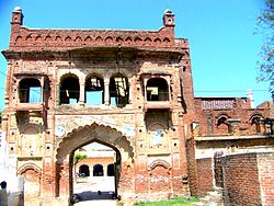
Sambalhera is an ancient village in Jansath Tehsil of Muzaffarnagar district, Uttar Pradesh, India, 6 km from Jansath town. Chhatraudi branch of Sadat Bahera settled here in the 11th century. Many ancient and medieval tombs of Barha generals are still there.

<span class="mw-page-title-main">Sayyed Mahmud Khan</span>

Amiral Kabir Sayyid Mahmud Khan Barha, also known as Mahmud Khan and mahmud dewaan, was a general in the Akbar's army, son of Sayyid Mubarak, was the first person of this family - the Sayyids of Barah - to rise to the rank of a nobleman. This he did through his bravery and valour during the Timurid dynasty. He joined the service of Bairam Khan.

<span class="mw-page-title-main">Shamli district</span> District of Uttar Pradesh in India

Shamli is a district in the Indian state of Uttar Pradesh. This district was carved out from Muzaffarnagar District on 28 September 2011 as Prabudh Nagar and renamed Shamli in July 2012. Shamli is the headquarters of the district. Shamli is located along the Delhi-Saharanpur-Dehradun Expressway, Ambala-Shamli Expressway, Gorakhpur-Shamli Expressway, Delhi–Saharanpur, Meerut-Karnal and Panipat-Khatima Highways.

<span class="mw-page-title-main">Abdullah Khan Barha</span> Nawab of Ajmer

Nawab Sayyid Abdullah Khan I also known as Sayyid Mian I, was the father of Hassan Ali Khan Barha and Hussain Ali Khan Barha, the two famous Sayyid Brothers. His full name was Sayyid Abdullah Khan Tihanpuri, Tihanpur was the ancestral village of this branch of Sayyids in Patiala Punjab.

<span class="mw-page-title-main">Barha dynasty</span>

The Barha dynasty was a Shi'a Indian Muslim dynasty that was influential in India during the era of Delhi Sultanate and Mughal Empire.

<span class="mw-page-title-main">Urdu-speaking people</span>

Native speakers of Urdu are spread across South Asia. The vast majority of them are Muslims of the Hindi–Urdu Belt of northern India, followed by the Deccani people of the Deccan plateau in south-central India, the Muhajir people of Pakistan, Muslims in the Terai of Nepal, and the Biharis and Dhakaiyas of Old Dhaka in Bangladesh. The historical centres of Urdu speakers include Delhi and Lucknow, as well as the Deccan, and in the modern era, Karachi. Another defunct variety of the language was historically spoken in Lahore for centuries before the name "Urdu" first began to appear. However, little is known about this defunct Lahori variety as it has not been spoken for centuries.

References

  1. "District-specific Literates and Literacy Rates, 2011". Registrar General, India, Ministry of Home Affairs. Retrieved 10 October 2010.
  2. Cadell, Alan (1873). Settlement Report of the District of Muzaffarnagar: Including a Report on the Permanent Settlement of the Western Parganas of the District, and Also a Report on the Settlement of the Ganges Canal Tract. North-Western Provinces and Oudh Government Press. p. 31.
  3. "Brief District History". Muzaffarnagar district website. Archived from the original on 14 September 2013. Retrieved 9 September 2013.
  4. Marmaduke William Pickthall, Muhammad Asad (1933). Islamic Culture:Volume 7. p. 439.
  5. David Ross (1883). The Land of the Five Rivers and Sindh. p. 266.
  6. William Wilson Hunter (1885). The Imperial Gazetteer of India: Volume 10. the University of California. p. 68.
  7. William Irvine (1971). Later Mughal. Atlantic Publishers & Distri. p. 202.
  8. Rajasthan Institute of Historical Research (1975). Journal of the Rajasthan Institute of Historical Research: Volume 12. Rajasthan Institute of Historical Research.
  9. Zahiruddin Malik (1977). The Reign Of Muhammad Shah 1919-1748. p. 32.
  10. Abdul Aziz (1964). Discovery of Pakistan. the University of Michigan. p. 136.
  11. Sen, Sailendra (2013). A Textbook of Medieval Indian History. Primus Books. p. 193. ISBN   978-9-38060-734-4.
  12. Mohammad Yasin. Upper India Publishing House. 1958. p. 18.
  13. "The streets of fear". India Today. Retrieved 28 January 2017.
  14. "Administration". Muzaffarnagar.nic.in. Archived from the original on 11 May 2012. Retrieved 8 August 2012.
  15. Decadal Variation In Population Since 1901
  16. 1 2 3 4 5 6 7 8 "District Census Handbook: Muzaffarnagar" (PDF). censusindia.gov.in. Registrar General and Census Commissioner of India. 2011.
  17. US Directorate of Intelligence. "Country Comparison:Population". Archived from the original on 13 June 2007. Retrieved 1 October 2011. Albania 2,827,800 July 2011 est.
  18. "2010 Resident Population Data". U. S. Census Bureau. Retrieved 30 September 2011. Oregon 3,831,074
  19. "Table C-01 Population by Religion: Uttar Pradesh". censusindia.gov.in. Registrar General and Census Commissioner of India. 2011.
  20. 1 2 "Table C-16 Population by Mother Tongue: Uttar Pradesh". www.censusindia.gov.in. Registrar General and Census Commissioner of India.

29°27′N77°35′E / 29.450°N 77.583°E / 29.450; 77.583