Kasganj district

Last updated

Kasganj district
कासगंज जनपद
Weather 2.jpg
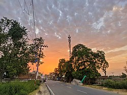
Sunset in Bilram
India Uttar Pradesh districts 2012 Kasganj.svg
Coordinates: 27°49′N78°39′E / 27.82°N 78.65°E / 27.82; 78.65
CountryFlag of India.svg  India
State Uttar Pradesh
Division Aligarh
Headquarters Kasganj
Area
  Total1,993 km2 (770 sq mi)
Population
 (2011)
  Total1,436,719
  Density720/km2 (1,900/sq mi)
Languages
  Official Hindi
Time zone UTC+5:30 (IST)
ISO 3166 code IN-UP-KN
Literacy62.3%
Website https://kasganj.nic.in/

Kasganj district (earlier called Kanshiram Nagar) is a district of the Indian state Uttar Pradesh. It is located in the division of Aligarh and consists of Kasganj, Patiali and Sahawar tehsils. Its headquarters is at Kasganj. [1]

Contents

History

The district lies in the cultural region of Braj. Kasganj was established on 15 April 2008 by separating Kasganj, Patiali and Sahawar tehsils from Etah district. For a while, the district was named after a politician, Kanshi Ram. The decision taken by Mayawati, chief minister of Uttar Pradesh and president of the BSP provoked protests by lawyers who had proposed to call it in honor of Sant Sant Tulsidas, who was born in the district, that place known as Soron (Sukarkshetra). [2] The district reverted to its original name in 2012. [3] Adjacent districts of Kasganj are Aligarh, Budaun, Etah, Farrukhabad and Khair Tehsil.

Demographics

Historical population
YearPop.±% p.a.
1901386,383    
1911389,747+0.09%
1921371,135−0.49%
1931384,897+0.36%
1941440,490+1.36%
1951502,930+1.33%
1961588,879+1.59%
1971699,806+1.74%
1981826,616+1.68%
1991991,289+1.83%
20011,228,705+2.17%
20111,436,719+1.58%
source: [4]
Religions in Kasganj district (2011) [5]
ReligionPercent
Hinduism
84.32%
Islam
14.88%
Other or not stated
0.80%
Distribution of religions

According to the 2011 census Kasganj district has a population of 1,436,719, [6] roughly equal to the nation of Eswatini [7] or the US state of Hawaii. [8] This gives it a ranking of 345th in India (out of a total of 640). [6] The district has a population density of 736 inhabitants per square kilometre (1,910/sq mi). [6] Its population growth rate over the decade 2001–2011 was 17.05%. [6] Kasganj has a sex ratio of 879 females for every 1,000 males, [6] and a literacy rate of 62.3%. 20.06% of the population lived in urban areas. Scheduled Castes make up 17.70% of the population. [6]

Languages of Kasganj district (2011) [9]

   Hindi (91.45%)
   Urdu (8.27%)
  Others (0.28%)

At the time of the 2011 Census of India, 91.45% of the population in the district spoke Hindi and 8.27% Urdu as their first language. [9] The local languages are Brajbhasha and Kannauji.

See also

Related Research Articles

<span class="mw-page-title-main">Bulandshahr district</span> District of Uttar Pradesh in India

Bulandshahr district is a district in the Meerut region in the North Indian state of Uttar Pradesh (UP), situated between the two rivers Ganga and Yamuna. It is a part of the National Capital Region of India, and Bulandshahr is the district headquarters.

<span class="mw-page-title-main">Agra district</span> District of Uttar Pradesh in India

Agra district is one of the 75 Districts of Uttar Pradesh, India. The district headquarters is the historical city of Agra. Agra district is a part of Agra division.

<span class="mw-page-title-main">Aligarh district</span> District of Uttar Pradesh in India

Aligarh district is a district in the state of Uttar Pradesh, India. This district is a part of Aligarh Division. The districts which adjoin Aligarh are Gautam Buddha Nagar, Bulandshahr, Sambhal, Badaun, Kasganj, Hathras and Mathura.

<span class="mw-page-title-main">Etah district</span> District of Uttar Pradesh in India

Etah district is one of the districts of Uttar Pradesh, India, since 1854. Etah City is the district headquarters. Etah district is a part of Aligarh Division.

<span class="mw-page-title-main">Ayodhya district</span> District of Uttar Pradesh in India

Ayodhya district is an administrative district of the Indian state of Uttar Pradesh. The city of Ayodhya is its administrative headquarters. The district occupies an area of 2,522 square kilometres (974 sq mi), and had a population of 2,470,996 in the 2011 census. Ayodhya district shares its borders with 6 districts of Uttar Pradesh. It is bordered by Gonda and Basti districts on the northern side, Amethi and Sultanpur districts on the south, and Ambedkar Nagar and Barabanki districts share the border on the east and west.

<span class="mw-page-title-main">Hathras district</span> District of Uttar Pradesh in India

Hathras district is a district of Uttar Pradesh state of India. The city of Hathras is the district headquarters. Hathras district is a part of Aligarh division. The district occupies an area of 1,840 square kilometres (710 sq mi) and has a population of 1,564,708 as of the 2011 census.

<span class="mw-page-title-main">Sant Kabir Nagar district</span> District of Uttar Pradesh in India

Sant Kabir Nagar district is one of the 75 districts of Uttar Pradesh state in northern India. Khalilabad is the district headquarters. Sant Kabir Nagar district is a part of Basti division. The total area of Sant Kabir Nagar district is 1,646 km2 (636 sq mi).

<span class="mw-page-title-main">Hamirpur district, Uttar Pradesh</span> District of Uttar Pradesh in India

Hamirpur district is one of the 75 districts of Uttar Pradesh state of India and Hamirpur town is the district headquarters. Hamirpur district is a part of Chitrakoot Division. The district occupies an area of 4,121.9 km². The district has a population of 1,104,285. As of 2011 it is the third least populous district of Uttar Pradesh, after Mahoba and Chitrakoot. Two major rivers Yamuna and Betwa meet here. On the banks of river Betwa lies the "Coarse sand" which is exported to many parts in U.P.

<span class="mw-page-title-main">Ambedkar Nagar district</span> District of Uttar Pradesh, India

Ambedkar Nagar is a district in the Indian state of Uttar Pradesh. This district is a part of Ayodhya division in the Awadh region of the state. This district was established on 29 September 1995 by carving out parts of the erstwhile Faizabad district. It was created by the then Chief Minister Mayawati and named in memory of Bhimrao Ambedkar, who worked for the advancement of the depressed classes. The total area of Ambedkar Nagar district is 2350 Sq. Km.

<span class="mw-page-title-main">Kanpur Nagar district</span> District of Uttar Pradesh in India

Kanpur Nagar district, meaning Urban Kanpur District is one of the districts of the Uttar Pradesh state of India. It is a part of Kanpur division and its district headquarters is Kanpur. Kanpur was formerly spelled Cawnpore.

<span class="mw-page-title-main">Maharajganj district</span> District of Uttar Pradesh in India

Maharajganj district is one of the 75 districts of Uttar Pradesh state in northern India, and the town of Maharajganj is the district headquarters. District is a part Gorakhpur division. It is located in Terai region of Himalayas, bordering Nepal in North. Gandak, Rapti, Rohin are some major river flowing through the district.

<span class="mw-page-title-main">Bhadohi district</span> District in Uttar Pradesh, India

Bhadohi District is a district of Uttar Pradesh state in northern India. The city of Bhadohi is the district headquarters. Bhadohi is one of largest centres of Carpet Industries in India and is worldwide known as 'Carpet City of India'. Carpets of Bhadohi have 'Geographical Indication' tag attached to it. Bhadohi has huge geographical significance and position attached to it due to its location between two culturally important and rich heritage cities of Prayagraj and Varanasi.

<span class="mw-page-title-main">Moradabad district</span> District of Uttar Pradesh in India

Moradabad district is one of the districts of Uttar Pradesh, India. Moradabad is the district headquarters. Moradabad district is a part of Moradabad division. It is used to be the second most populous district of Uttar Pradesh, after Prayagraj till a new district Sambhal was carved out of it in 2011.

<span class="mw-page-title-main">Gorakhpur district</span> District of Uttar Pradesh in India

Gorakhpur district is one of the 75 districts of Uttar Pradesh state in northern India. This district is a part of the Gorakhpur division. The city of Gorakhpur, or Gorakhpur is the administrative headquarters of this district and Gorakhpur division. It borders Sant Kabir Nagar district to the west, Kushinagar and Deoria districts to the east, and Maharajganj and Azamgarh districts to the north and south.

Kasganj is a city and the district headquarters of Kasganj district in the Indian state of Uttar Pradesh. The district was formed by grouping three Tehsils at 17 April 2008.

Sahawar is a town and a nagar panchayat, as well as Tehsil in Kasganj district in the Indian State of Uttar Pradesh. Previously, it was part of district Etah. Ms. Nashi Khan D/o Mrs. Najeeba Khan Zeenat is the present chairperson of Sahawar Town. The Block Sahawar was established in 01/04/1958.

<span class="mw-page-title-main">Kanpur Dehat district</span> District of Uttar Pradesh in India

Kanpur Dehat district is a district in Uttar Pradesh state in northern India. The administrative headquarters of the district are at Mati-Akbarpur. This district is part of Kanpur division. Kanpur was formerly spelled Cawnpore.

<span class="mw-page-title-main">Amethi district</span> District of Uttar Pradesh in India

Amethi district is the 72nd district of the state of Uttar Pradesh in northern India. This district is a part of Ayodhya division in the Awadh region of the Uttar Pradesh. It covers an area of 2329.11 km2. Gauriganj is the administrative headquarters of the district.

<span class="mw-page-title-main">Sambhal district</span> District of Uttar Pradesh in India

Sambhal district is a district of Uttar Pradesh state in India. The district headquarter is Bahjoi town. 993 Villages and 16 Police stations fall under Sambhal district.

<span class="mw-page-title-main">Hapur district</span> District of Uttar Pradesh in India

Hapur district is a recently formed district in the Indian state of Uttar Pradesh with a population of 1,338,211 at the 2011 Census. It arose as an area leading in the trade of grains and jaggery. This district on the Ganges river is 60 kilometres (37 mi) from New Delhi. Being located on the river could be a reason for its prosperity in trade.It is the smallest district of Uttar Pradesh.

References

  1. "Kanshiram Nagar to be State's 71st district". Archived from the original on 13 May 2009. Retrieved 20 May 2015.
  2. Lawyers against naming new Kasganj district after Kanshi Ram
  3. "Important Cabinet Decisions". Lucknow: Information and Public Relations Department. Retrieved 17 January 2013.
  4. Decadal Variation In Population Since 1901
  5. "Table C-01 Population by Religion: Uttar Pradesh". censusindia.gov.in. Registrar General and Census Commissioner of India. 2011.
  6. 1 2 3 4 5 6 "District Census Handbook: Kasganj" (PDF). censusindia.gov.in. Registrar General and Census Commissioner of India. 2011.
  7. US Directorate of Intelligence. "Country Comparison:Population". Archived from the original on 13 June 2007. Retrieved 1 October 2011. Swaziland 1,370,424
  8. "2010 Resident Population Data". U. S. Census Bureau. Archived from the original on 1 January 2011. Retrieved 30 September 2011. Hawaii 1,360,301
  9. 1 2 "Table C-16 Population by Mother Tongue: Uttar Pradesh". www.censusindia.gov.in. Registrar General and Census Commissioner of India.