Kanpur division

Last updated

Kanpur division
Kanpur division.svg
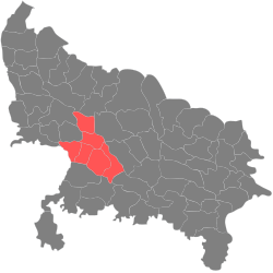
Location of Kanpur division in Uttar Pradesh
CountryIndia
State Uttar Pradesh
Area
  Total
14,810 km2 (5,720 sq mi)
Population
 (2011) [1]
  Total
12,873,369
  Density870/km2 (2,300/sq mi)

Kanpur division is one of the 18 administrative geographical units (i.e. division) of the northern Indian state of Uttar Pradesh. Kanpur city is the administrative headquarters of the division. Kanpur was formerly spelled Cawnpore. The division consists of 6 districts:-

Contents

Literacy rates

Kanpur division is the most literate division in Uttar Pradesh with literacy rates of:-[ citation needed ]

History of administrative districts in Kanpur Division

Kanpur division was earlier part of the Allahabad division. In the year 2000, the Mayawati government did a major reshuffle of the Allahabad division, and a separate Kanpur division was created.

The Kanpur district itself was bifurcated into Kanpur Dehat and Kanpur Nagar. Kanpur Dehat was renamed as Ramabai Nagar, after Ramabai (1896-1935), the wife of Bhimrao Ramji Ambedkar. In 2012, the name was changed back to Kanpur Dehat (though the 2011 Indian census uses the name "Kanpur Dehat").

RankUrban AreaArea (km sq.)2011 (Provisional figures)Coverage
1 Kanpur 4502,920,067Includes Kanpur Cantonment and Chakeri
2 Farrukhabad 40275,754Includes Fatehgarh
3 Etawah 35256,790
4 Auraiya 2564,598
5 Kannauj 2071,530
6 Ghatampur 1235,496
7 Chhibramau 1050,279
8 Bharthana 1038,781

Cities by GDP

Demographics

Kanpur division: mother-tongue of population, according to the 2011 Census. [2]
Mother tongue codeMother tongueDistrictsKanpur division
FarrukhabadKannaujEtawahAuraiyaKanpur DehatKanpur NagarTotal peoplePercentage
002007 Bengali 4661981513371,06914,34116,5620.13%
005018 Gujarati 11135410465767640.01%
006102 Bhojpuri 7017362726165,0086,5140.05%
006240 Hindi 1,790,2751,600,6771,553,0871,359,1811,777,6834,234,66412,315,56795.61%
006340 Kumauni 100008238240.01%
006489 Rajasthani 116253985187471,0300.01%
010008 Maithili 151310115837670.01%
011016 Malayalam 7886112251,6671,9410.02%
013071 Marathi 3916557774,0244,2180.03%
014011 Nepali 28334421,8651,9360.02%
015043 Odia 125123257121,2891,5270.01%
016038 Punjabi 2,644731341635136,22839,2930.31%
017002 Sanskrit 024309329410.01%
019014 Sindhi 14042121406,6036,9730.05%
020027 Tamil 2672259535499410.01%
021046 Telugu 2422613407098950.01%
022015 Urdu 88,25247,87727,53218,86316,829263,375462,7283.59%
040001 English 41228545642,4842,7410.02%
Others 1,8456,8952722344184,80114,4650.11%
Total1,885,2041,656,6161,581,8101,379,5451,796,1844,581,26812,880,627100.00%

References

  1. "Indian Districts by Population, Sex Ratio, Literacy 2011 Census".
  2. C-16 Population By Mother Tongue – Uttar Pradesh (Report). Office of the Registrar General & Census Commissioner, India. Retrieved 15 July 2020.

26°28′12″N80°19′48″E / 26.47000°N 80.33000°E / 26.47000; 80.33000