Akbarpur is a town in Kanpur Dehat district in the state of Uttar Pradesh, India.

Jhinjhak is a town and a Municipal council in Kanpur Dehat district, India. The town is situated on the Lower Ganges Canal and is approximately 20 kilometres (12 mi) from the industrial city of Dibiyapur.
Rura is a Nagar Panchayat in Kanpur Dehat District in Uttar Pradesh state of the India. The town is situated on the banks of Lower Ganga canal. The district headquarters is 15 km away at Mati. The town is located at a distance of 49 km from famous industrial and educational hub of Kanpur Nagar.
Shivli or Sheoli is a town and a nagar panchayat in Kanpur Dehat district in the Indian state of Uttar Pradesh. It is located at 26°37′0″N80°3′0″E and has an average elevation of 128 meters (423 feet).
Tundla is a town and a municipal board in Firozabad district in the Indian state of Uttar Pradesh.
Bhognipur or Bhoganipur is a town in Kanpur Dehat district in the Indian state of Uttar Pradesh. It is the headquarters of the Tehsil of the same name and consists of the Amraudha and Malasa Development Blocks.
Rajpur is a town in Kanpur Dehat district in the state of Uttar Pradesh, with having all facilities like schools, hospital, and market for a normal Indian lifestyle. approximately 17 km west of Bhognipur and 12 km east of Sikandara on NH 2A. It is a development block of Sikandara tehsil. The nearest Railway Station is Pukhrayan with a distance of approx. 20 km and the nearest airport is CCSA, Amaus, Lucknow, approximately 160 km away.
Ghatampur is a town and a municipal board in Kanpur Nagar district in the state of Uttar Pradesh, India.It is located near main industrial and educational hubs of the state Kanpur at a distance of 40 km.
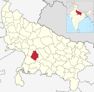
Kanpur Dehat district is a district in Uttar Pradesh state in northern India. The administrative headquarters of the district are at Mati-Akbarpur. This district is part of Kanpur division. Kanpur was formerly spelled Cawnpore.
Bidhuna is a big town and a Nagar Panchayat in Auraiya district in the state of Uttar Pradesh, India. Bidhuna has some temples. Durga Devi Mandir is one of the oldest temple in the town. Bidhuna also have known as priest people live in bidhuna and around the town. Kotwali situated near State Bank of India, feeder road. Feeder road as like as Cannaught place of Bidhuna. famous market of Bidhuna Loha Mandi, Sabji Mandi, Gala Mandi, Takiya also most famous place. It is also a educational hub for surrounding villages. It has several degree colleges and good quality schools which attract numerous students.

Bhaupur is a town in Kanpur Dehat district in the state of Uttar Pradesh, India.With World Bank funding development of Bhaupur Industrial Sector UPSIDC Amritsar-Kolkata dedicated freight corridor is being carried out.
Paman is a village in Kanpur Dehat district in the state of Uttar Pradesh, India.
Derapur is a town in Kanpur Dehat district in the state of Uttar Pradesh, India. It is the headquarters of the Tehsil of the same name. Derapur is 61 km (38 mi) away from Kanpur city.

Rasulabad is both a tehsil and a town in the Kanpur Dehat district, Uttar Pradesh, India.
Jignipurwa is a village at Sarwan Khera in Kanpur Dehat, northern India.
Bhatauli is an Indian village of Kanpur Dehat district in Uttar Pradesh.It is an adjacent to city Rura, Kanpur Dehat District, Uttar Pradesh, India. Bhatauli is the commercial center of grain and vegetables. It is well known place for potatoes cold storage. Many primary schools are in government sector while many others in private (recognized). Saraswati Gyan Mandir Inter College is also here. Jog Mai is a center of faith. The Shiv Bajrang Dham Kishunpur is 200 metres (660 ft) away.
Injuwarampur is a village in Kanpur Dehat district in the state of Uttar Pradesh, India.

Akbarpur Inter College is a senior secondary school in Kanpur Dehat district, Uttar Pradesh, India. The school is affiliated with U P Madhyamik Shiksha Parishad. It is a government aided institution.

Parhul Devi Temple is a temple to the Goddess Durga in the village of Lamahra in Kanpur Dehat district, Uttar Pradesh, India.


