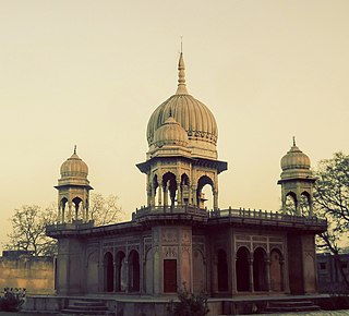
Aligarh is a city in the state of Uttar Pradesh in India. It is the administrative headquarters of Aligarh district, and lies 342 kilometres (213 mi) northwest of state capital Lucknow and approximately 130 kilometres (81 mi) southeast of the capital, New Delhi. The cities and districts which adjoin Aligarh are: Gautam Buddha Nagar, Bulandshahr, Sambhal, Badaun, Kasganj, Hathras, Etah and Mathura, as well as Palwal district of Haryana. As of 2011, Aligarh is the 53rd most populous city in India.

Agra division is one of the 18 administrative geographical units of the northern Indian state of Uttar Pradesh. It contains 4 districts i.e. Agra, Firozabad, Mainpuri and Mathura districts. The population of Agra Division was 11,304,646 as of 2011 census. Agra city is the headquarters of this division.

Hathras is a historical city in Uttar Pradesh, India. It is the headquarters of Hathras district, formed on 3 May 1997 by merging parts of Aligarh, Mathura and Agra. It is part of the Aligarh Division.

Bulandshahr district is a district in the Meerut region in the north Indian state of Uttar Pradesh (UP), situated between the Ganga and Yamuna rivers. It is a part of the National Capital Region of India, and Bulandshahr is the district headquarters.

Etah district is one of the districts of Uttar Pradesh, India, since 1854. Etah City is the district headquarters. Etah district is a part of Aligarh Division.

Hathras district is a district of Uttar Pradesh state of India. The city of Hathras is the district headquarters. Hathras district is a part of Aligarh division. The district occupies an area of 1,840 square kilometres (710 sq mi) and has a population of 1,564,708 as of the 2011 census.
Atrauli is a town and a municipal board in Aligarh district in the state of Uttar Pradesh, India. Situated on the bank of the river Ganges, Atrauli is around 27 km (17 mi) from Aligarh and 52 km (32 mi) from Khair.
Bahjoi is a Nagar Palika Parishad city in Sambhal district, Moradabad division, in the Indian state of Uttar Pradesh. Bahjoi is the headquarter of Sambhal district. In the past years of its life it was famous for the glass factory during the british colonisation.
Iglas is a town and tehsil in Aligarh district in the Indian state of Uttar Pradesh.
Jalesar is a Nagar Palika in Etah Sub District, Etah district in the Indian state of Uttar Pradesh. There is a fort of Awagarh near Jalesar, Awagarh is 15 kilometres (9.3 mi) from Jalesar It is connected by road to other towns such as Hathras, Etah, Aligarh, Firozabad and Agra.
Jewar is a town and a nagar panchayat in Gautam Buddha Nagar district in the Indian state of Uttar Pradesh. Noida, Dadri and Jewar are the 3 sub-divisions of GB Nagar district, each headed by a SDM.
Khair is a town and a municipal board in Aligarh district in the Indian state of Uttar Pradesh. Khair is the biggest town of Aligarh district. It is situated around 27 km from Aligarh, 114 km from Delhi and 60 km from Mathura.
Raja Ka Rampur is a town, and one of oldest nagar panchayat in Etah district in the Indian state of Uttar Pradesh.

Sambhal is a city located in the Sambhal district of Uttar Pradesh, India. The city lies approximately 158 km (98 mi) east of New Delhi and 355 km (220 mi) north-west of state capital Lucknow. It also falls within the Rohilkhand region in the Moradabad division of the state, being approximately 32 km (20 miles) from the city of Moradabad.
Sikandra Rao is a town in Hathras district of Uttar Pradesh. It is one of the three assembly constituencies of the district and a Municipal board. The current MLA from the constituency is senior BJP leader Birendra Singh Rana.The town is connected to the cities of Aligarh and Etah by NH-34 and to the city of Agra by NH-21. The nearest airport is Agra Airport.

The Roman Catholic Archdiocese of Agra is a Latin Metropolitan archdiocese in northern India's Uttar Pradesh state. It comproses the following districts in Uttar Pradesh: Agra, Aligarh, Auraiya, Budaun, Bulandshahr, Etah, Etawah, Farrukabad, Firozabad, Gautambudha Nagar, Hathras, Kannauj, Mainpuri, Mathura and in Rajasthan: Bharatpur and Dholpur.
Gonda is a town in Aligarh district in the Indian state of Uttar Pradesh.

Sambhal district is a district of Uttar Pradesh state in India. The district headquarter is Bahjoi town. 993 villages and 16 police stations fall under Sambhal district.

Kasganj district is a district of the Indian state Uttar Pradesh. It is located in the division of Aligarh and consists of Kasganj, Patiali and Sahawar tehsils. Its headquarters is at Kasganj.
Diocese of Agra is an Anglican diocese under the Church of North India. Diocese of Agra, within the Church of North India, was constituted by the decision of the Synod Executive of the Church of North India. The new Diocese thus formed comprising the western part of Uttar Pradesh was named the Diocese of Agra. The Diocese's constitution was accepted and adopted by Minutes 76/6 at the first ordinary meeting of the Diocesan Council of the Diocese of Agra which held its session in St. John's College, Agra Hall, on 9 April 1976.


