
Prayagraj division, formerly known as Allahabad division, is one of the 18 administrative geographical units of the northern Indian state of Uttar Pradesh, with the city of Prayagraj being the administrative divisional headquarters.

Bareilly division is one of the 18 administrative geographical unit of the northern Indian state of Uttar Pradesh. Bareilly city is the administrative headquarters of the division. Part of the Rohilkhand region, Bareilly division consists of four major districts in western Uttar Pradesh - Bareilly, Badaun, Pilibhit and Shahjahanpur.

Chitrakoot division is one of the 18 administrative geographical units of the northern Indian state of Uttar Pradesh. Chitrakoot Dham is the administrative headquarters of this division. Historically part of the Bundelkhand region, it includes the 4 districts of:-
Mubarakpur is a town and a municipal board in Azamgarh district in the Indian state of Uttar Pradesh. It is located at a distance of 13 km north-east of the district headquarters in Azamgarh.

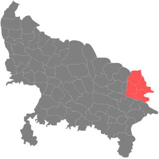
Azamgarh district is one of the three districts of Azamgarh division in the Indian state of Uttar Pradesh.

Mau district is one of the districts of Uttar Pradesh state of India, and Mau town is the district headquarters which is also one of the few remaining areas of handloom saree production in eastern Uttar Pradesh, specializing in Sadiya silk sarees. Mau was carved out as a separate district from Azamgarh on 19 November 1988. It is situated in the south-eastern part of the state with headquarters in Maunath Bhanjan. The district is surrounded by Ghazipur district on the south, Ballia district in the east, Azamgarh district in the west, and by Gorakhpur and Deoria districts on the north; says, Pallavi mishra.

Ambedkar Nagar is a district in the Indian state of Uttar Pradesh. This district is a part of Ayodhya division in the Awadh region of the state. This district was established on 29 September 1995 by carving out parts of the erstwhile Faizabad district. It was created by the then Chief Minister Mayawati and named in memory of Bhimrao Ambedkar, who worked for the advancement of the depressed classes. The total area of Ambedkar Nagar district is 2350 Sq. Km.
Gorakhpur division is one of the 18 administrative geographical units of the northern Indian state of Uttar Pradesh. Gorakhpur city is the administrative headquarters of the division. The division consists of 4 districts.

Devipatan division is one of the 18 administrative geographical units of the northern Indian state of Uttar Pradesh. Currently, the division consists of 4 districts, of which Gonda city is the divisional headquarters:-
Gorakhpur district is one of the 75 districts of Uttar Pradesh state in northern India. This district is a part of the Gorakhpur division. The city of Gorakhpur, or Gorakhpur is the administrative headquarters of this district and Gorakhpur division. It borders Sant Kabir Nagar district to the west, Kushinagar and Deoria districts to the east, and Maharajganj and Azamgarh districts to the north and south.
Bilariaganj is the second largest city and a Nagar Palika Parishad in Azamgarh division after its capital city Azamgarh in the state of Uttar Pradesh, India.
Nizamabad is a town and a nagar panchayat in Azamgarh district in the Indian state of Uttar Pradesh. The city is well known for its black clay pottery.

Aligarh division is one of the 18 administrative geographical units of the northern Indian state of Uttar Pradesh. Aligarh city is the divisional headquarters.
Azamgarh Lok Sabha constituency is one of the 80 Lok Sabha (parliamentary) constituencies in Uttar Pradesh state in northern India.
Azamgarh is a constituency of the Uttar Pradesh Legislative Assembly covering the city of Azamgarh in the Azamgarh district of Uttar Pradesh, India.
Mubarakpur is a constituency of the Uttar Pradesh Legislative Assembly covering the city of Mubarakpur in the Azamgarh district of Uttar Pradesh, India.
Sagri is a constituency of the Uttar Pradesh Legislative Assembly covering the city of Sagri in the Azamgarh district of Uttar Pradesh, India. It is one of five assembly constituencies in the Azamgarh Lok Sabha constituency. Since 2008, this assembly constituency is numbered 345 amongst 403 constituencies.
Phoolpur Pawai is a constituency of the Uttar Pradesh Legislative Assembly covering the city of Phoolpur Pawai in the Azamgarh district of Uttar Pradesh, India.
Nizamabad is a constituency of the Uttar Pradesh Legislative Assembly covering the city of Nizamabad in the Azamgarh district of Uttar Pradesh, India.
Mehnagar is a constituency of the Uttar Pradesh Legislative Assembly covering the city of Mehnagar in the Azamgarh district of Uttar Pradesh, India.
