Prayagraj district

Last updated

Prayagraj district
Sangam Nagri
Allahabad district
Allahabad, Triveni Sangam 27 (39310070552).jpg
Allahabad, Khusru bagh, Nithar tomb (2) 2015-11-12.jpg
Bara Thermal Power Project (39418033715).jpg
AnandBhawan.JPG
Yamuna bridge Prayagraj.jpg
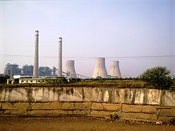
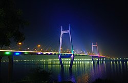
Clockwise from top-left: Triveni Sangam, Tomb of Nihar Begum at Khusro Bagh, Anand Bhavan, New Yamuna Bridge, Bara Thermal Power Station
India Uttar Pradesh districts 2012 Allahabad.svg
Location of Prayagraj district in Uttar Pradesh
CountryFlag of India.svg India
State Uttar Pradesh
Division Prayagraj
Headquarters Prayagraj
Tehsils 8
Government
   Divisional Commissioner Sanjay Goyal IAS [1]
   District Magistrate Sanjay Khatri IAS
Area
  Total
5,482 km2 (2,117 sq mi)
Population
 (2011)
  Total
5,954,391
  Density1,100/km2 (3,000/sq mi)
Demographics
   Literacy 74.41%
   Sex ratio 901
Time zone UTC+05:30 (IST)
Vehicle registration UP 70
Major highways NH 19
Lok Sabha constituencies Allahabad
Phulpur
Website prayagraj.nic.in

Prayagraj district, formerly known as Allahabad district, [2] is the most populous district in the Indian state of Uttar Pradesh. Prayagraj city is the district headquarters of this district. The District is divided into blocks within tehsils. As of 2011, there are 20 blocks in eight tehsils. [3] [4] [5] The Prayagraj division includes the districts of Pratapgarh, Fatehpur, Kaushambi and Prayagraj, with some western parts that had previously been part of Allahabad District becoming part of the new Kaushambi District. [6] The administrative divisions are Phulpur, Koraon, Meja, Sadar, Soraon, Handia, Bara, Shringverpur and Karchana.

Contents

The three rivers of India - Ganges, Yamuna and the mythical river of Sarasvati - meet at a point in the district, known as Triveni Sangam, considered holy by Hindus. Prayagraj is one of the largest educational hubs.

Demographics

Historical population
YearPop.±% p.a.
19011,141,944    
19111,124,143−0.16%
19211,076,120−0.44%
19311,142,845+0.60%
19411,388,068+1.96%
19511,568,592+1.23%
19611,882,506+1.84%
19712,292,284+1.99%
19812,983,245+2.67%
19913,899,660+2.71%
20014,937,266+2.39%
20115,954,391+1.89%
source: [7]

According to the 2011 Census of India the district has a population of 5,954,391. [7] This gives it a ranking of 13th in India (out of a total of 640). [7] As of 2011 it is the most populous district of Uttar Pradesh (out of 71). [7] The district has a population density of 1,087 inhabitants per square kilometre (2,820/sq mi). [7] Its population growth rate over the decade 2001-2011 was 20.74%. [7]

The district has a sex ratio of 902 females for every 1000 males, [7] and a literacy rate of 74.41%, highest in the region [8] and close to the all-India average of 74%. 24.75% of the population lives in urban areas. Scheduled Castes made up 22.00% of the population. [7]

Religion

Religions in Prayagraj district (2011) [9]
ReligionPercent
Hinduism
85.69%
Islam
13.38%
Other or not stated
0.93%

Hinduism is majority religion in the district with 85.69% followers. Islam is second most popular religion in district of Prayagraj with approximately 13.38% following it. Around 0.93% stated 'Other Religion', approximately 0.51% stated 'No Particular Religion'. Small numbers of Christians live in the district. [9]

The Prayag Kumbh Mela is a major Hindu event. Prayagraj has a Triveni Sangam. Akshayavat is a sacred fig tree. There is a Roman Catholic Diocese of Allahabad.

Languages

Languages of Prayagraj district (2011) [10]
  1. Hindi (94.9%)
  2. Urdu (2.69%)
  3. Awadhi (1.86%)
  4. Others (0.54%)

See also

References

  1. "Shri Sanjay Goyal, IAS | District Prayagraj, Government of Uttar Pradesh | India". prayagraj.nic.in. Retrieved 25 March 2021.
  2. "District Prayagraj, Government of Uttar Pradesh | the City of Kumbh | India" . Retrieved 5 April 2020.
  3. "Development Blocks under Tehsils". District court of Allahabad. Archived from the original on 26 May 2012. Retrieved 4 August 2012.
  4. Hridai Ram Yadav (2009). Village Development Planning. Concept Publishing Company. pp. 9–13. ISBN   978-81-7268-187-6 . Retrieved 4 August 2012.
  5. Pramod Lata Jain (1990). Co-operative Credit in Rural India: A Study of Its Utilisation. Mittal Publications. pp. 61–63. ISBN   978-81-7099-204-2 . Retrieved 4 August 2012.
  6. "Maps, Tahsils and villages of Allahabad". Explore Allahabad Press. Archived from the original on 21 October 2014. Retrieved 12 January 2014.
  7. 1 2 3 4 5 6 7 8 "District Census Handbook: Allahabad" (PDF). censusindia.gov.in. Registrar General and Census Commissioner of India. 2011.
  8. "Allahabad has highest literacy rate in region". The Times of India . 15 April 2011. Archived from the original on 6 May 2013. Retrieved 3 August 2012.
  9. 1 2 "Table C-01 Population by Religion: Uttar Pradesh". censusindia.gov.in. Registrar General and Census Commissioner of India. 2011.
  10. 1 2 "Table C-16 Population by Mother Tongue: Uttar Pradesh". www.censusindia.gov.in. Registrar General and Census Commissioner of India.
  11. Awadhi at Ethnologue (25th ed., 2022) Closed Access logo transparent.svg
  12. Bagheli at Ethnologue (25th ed., 2022) Closed Access logo transparent.svg

25°27′N81°51′E / 25.450°N 81.850°E / 25.450; 81.850