Amroha district

Last updated

Amroha district
Main Gate - panoramio (3).jpg
Rauza Haz, Shah Abbas Badr-e-Chisti in Amroha
India Uttar Pradesh districts 2012 Amroha.svg
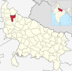
Location of Amroha district in Uttar Pradesh
CountryFlag of India.svg India
State Uttar Pradesh
Division Moradabad
Established as a district24th April 1997
Headquarters Amroha
Sub Division / Tehsils
  1. Amroha
  2. Hasanpur
  3. Dhanaura
  4. Naugawan Sadat
Government
   Lok Sabha constituency Amroha
   Vidhan Sabha Seats
  1. 39Dhanaura (SC)
  2. 40Naugawan Sadat
  3. 41Amroha
  4. 42Hasanpur
Area
  Total
2,321 km2 (896 sq mi)
Population
 (2011)
  Total
1,840,221
  Density790/km2 (2,100/sq mi)
   Urban
56%
Demographics
   Literacy 50.21% [1]
   Sex ratio 925
Time zone UTC+05:30 (IST)
Vehicle registration UP-23
Average annual precipitation1,120 mm
Website Official Website

Amroha district is one of the 75 districts of Uttar Pradesh. Amroha was earlier a part of Moradabad district. On 15 April 1997, it was separated from Moradabad and made a new district. This district was named Jyotiba Phule Nagar, but in 2012 it was changed to Amroha

Contents

History

The Battle of Amroha was fought between the Mongols and Alauddin Khilji on 20 December 1305. Alauddin won the battle. Later, the territory occupied by the present district was part of the Sambhal sarkar of Delhi subah under the Mughal empire. Later it came under the control of Awadh. In 1801, the administration of this territory was ceded to the British East India Company by the Nawab of Awadh. On 24 [2] April 1997, this district was carved out by separating Amroha, Dhanora and Hasanpur tehsils of the erstwhile Moradabad district. In 2012, this district was renamed from Jyotiba Phule Nagar district to Amroha district. [3]

Demographics

Historical population
YearPop.±% p.a.
1901328,739    
1911348,293+0.58%
1921330,488−0.52%
1931354,024+0.69%
1941406,143+1.38%
1951457,922+1.21%
1961550,228+1.85%
1971681,551+2.16%
1981891,539+2.72%
19911,155,742+2.63%
20011,499,068+2.64%
20111,840,221+2.07%
source: [4]

According to the 2011 census, 'Amroha District' has a population of 1,840,221, [5] roughly equal to the nation of Kosovo [6] or the US state of Nebraska. [7] This gives it a ranking of 258th in India (out of a total of 640). [5] The population density is 818 inhabitants per square kilometre (2,120/sq mi) [5] and the population growth rate over the decade 2001-2011 was 22.66%. [5] Amroha has a sex ratio of 907 females for every 1,000 males, [5] and a literacy rate of 65.7%. 24.93% of the population lived in urban areas. Scheduled Castes make up 17.28% of the population. [5]

Religion

Religions in Amroha district (2011) [8]
ReligionPercent
Hinduism
58.44%
Islam
40.78%
Others†
0.78%
Distribution of religions
Includes Christians (0.32%), Sikhs (0.29%), Buddhists (<0.01%).

Even though the district is Hindu majority, Muslims form a significant minority and dominate urban areas. As per the 2011 census out of 9 Census towns Muslims formed the majority in 7 while Hindus were in majority in Gajraula (77.33%) and Dhanaura (66.38%) towns. [8]

Tehsil Hindus Muslims Others
Dhanaura 66.34%32.22%1.44%
Amroha 45.32%53.94%0.74%
Hasanpur 69.32%30.35%0.33%

Language

Languages of Amroha district (2011) [9]
  1. Hindi (80.1%)
  2. Urdu (19.7%)
  3. Others (0.20%)

Villages

Notable people

Media

Amroha has several active media groups which continuously give the populace Hindi news updates on Amroha:

References

  1. "District-specific Literates and Literacy Rates, 2001". Registrar General, India, Ministry of Home Affairs. Retrieved 10 October 2010.
  2. "District Amroha, Government of Uttar Pradesh | Renowned for Dholak and Mango | India" . Retrieved 4 April 2022.
  3. "Important Cabinet Decisions". Lucknow: Information and Public Relations Department. Archived from the original on 24 October 2014. Retrieved 17 January 2013.
  4. Decadal Variation In Population Since 1901
  5. 1 2 3 4 5 6 "District Census Handbook: Amroha" (PDF). censusindia.gov.in. Registrar General and Census Commissioner of India. 2011.
  6. US Directorate of Intelligence. "Country Comparison:Population". Archived from the original on 13 June 2007. Retrieved 1 October 2011. Kosovo 1,825,632 July 2011 est.
  7. "2010 Resident Population Data". U. S. Census Bureau. Archived from the original on 19 October 2013. Retrieved 30 September 2011. Nebraska 1,826,341
  8. 1 2 "Table C-01 Population by Religion: Uttar Pradesh". censusindia.gov.in. Registrar General and Census Commissioner of India. 2011.
  9. 1 2 "Table C-16 Population by Mother Tongue: Uttar Pradesh". www.censusindia.gov.in. Registrar General and Census Commissioner of India.
  10. "Burawali Pin Code - 244241 | Burawali, Hasanpur Postal Code".
  11. "Hindi Newspapers". Amar Ujala . Retrieved 13 July 2016.

28°54′00″N78°28′12″E / 28.90000°N 78.47000°E / 28.90000; 78.47000

Rickard, J (7 April 2010), Battle of Amroha, 20 December 1305, historyofwar.org