Udham Singh Nagar district

Last updated

Udham Singh Nagar district
The ruins of Temple by the Pandava's in Kashipur.jpg
Nankana sahib, kashipur (3).jpg
Metropolis city rudrapur (2).jpg
Baigul Dam Lake 01.jpg
Sunset at Crops Research Center, Pantnagar.jpg
Clockwise from top-left: Palace of Dronacharya, Gurudwara Nanakana Sahib in Kashipur, Baigul Dam, Crops Research Center at Pantnagar, Metropolis city in Rudrapur
Udham Singh Nagar in Uttarakhand (India).svg
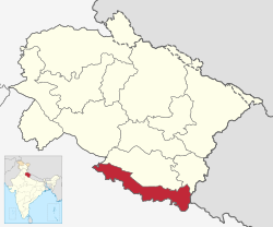
Location in Uttarakhand
Coordinates: 28°59′N79°24′E / 28.98°N 79.40°E / 28.98; 79.40
CountryFlag of India.svg India
State Uttarakhand
Division Kumaon
Founded byUdham Singh Nagar has been carved out of Nainital.
Named after Udham Singh
Headquarters Rudrapur
Government
   District Magistrate Mr. Uday Raj Singh, IAS [1]
Area
[2]
  Total
2,542 km2 (981 sq mi)
Population
 (2011) [3]
  Total
1,648,902
  Density650/km2 (1,700/sq mi)
Languages
  Official Hindi [4]
  Additional official Sanskrit [5] [6]
  Regional Kumaoni, Tharu
Time zone UTC+5:30 (IST)
Vehicle registration UK 06, UK 18
Website usnagar.nic.in

Udham Singh Nagar district is a district of Uttarakhand state in northern India. Rudrapur is the district headquarter. The district consists of nine Tehsils named Bajpur, Gadarpur, Jaspur, Kashipur, Khatima, Kichha, Nanakmatta, Rudrapur, Sitarganj. The district is located in the Terai region, and is part of Kumaon Division. It is bounded on the north by Nainital District, on the northeast by Champawat District, on the east by Nepal, and on the south and west by Bareilly, Rampur, Moradabad, Pilibhit and Bijnor District of Uttar Pradesh state. The district was created on 29 September 1995, [7] [8] by Mayawati government out of Nainital District. It is named for freedom fighter and Indian revolutionary Udham Singh. [9]

Contents

As of 2011, it is the third most populous district of Uttarakhand (out of 13), after Haridwar and Dehradun. [3]

Tehsils in Udham Singh Nagar district

  1. Jaspur
  2. Kashipur
  3. Bajpur
  4. Gadarpur
  5. Rudrapur
  6. Kichha
  7. Sitarganj
  8. Nanakmatta
  9. Khatima

Cities in Udham Singh Nagar

  1. Rudrapur
  2. Kashipur
  3. Khatima
  4. Sitarganj
  5. Kichha
  6. Jaspur
  7. Bajpur
  8. Gadarpur
  9. Dineshpur
  10. Pantnagar
  11. Nanakmatta
  12. Sultanpur

Administrative divisions

The district lies in Nainital–Udhamsingh Nagar (Lok Sabha constituency). which includes whole Nainital district as well as Udham Singh Nagar district. For election purposes Udham Singh Nagar district is divided into nine Vidhan Sabha constituencies:

  1. Bajpur Assembly constituency
  2. Kashipur Assembly constituency
  3. Rudrapur Assembly constituency
  4. Kichha Assembly constituency
  5. Sitarganj Assembly constituency
  6. Khatima Assembly constituency
  7. Gadarpur Assembly constituency
  8. Nanakmatta Assembly constituency
  9. Jaspur Assembly constituency

Demographics

Historical population
YearPop.±% p.a.
1901131,811    
1911131,608−0.02%
1921112,634−1.54%
1931112,804+0.02%
1941118,733+0.51%
1951136,446+1.40%
1961301,681+8.26%
1971451,717+4.12%
1981668,751+4.00%
1991924,856+3.30%
20011,235,614+2.94%
20111,648,902+2.93%
source: [10]

According to the 2011 census Udham Singh Nagar district has a population of 1,648,902, [3] roughly equal to the nation of Guinea-Bissau [11] or the US state of Idaho. [12] The population in the age range of 0–6 years was 229,162. The number of literates in Udham Singh Nagar district is 1,037,839 (62.9%), with 598,525 (68.7%) male literates and 751,789 (55.6%) female literates. The effective 7+ literacy of the district is 73.1%. The sex ratio of 920 females for every 1,000 males. [3] The Scheduled Castes and Scheduled Tribes population was 238,264 (14.45%) and 123,037 (7.46%) respectively. There were 308581 households in the district in 2011. [3]

Religions in Udham Singh Nagar district (2011) [13]
ReligionPercent
Hinduism
66.98%
Islam
22.58%
Sikhism
9.87%
Other or not stated
0.57%

Languages

Languages of Udham Singh Nagar district (2011) [14]
  1. Hindi (62.4%)
  2. Punjabi (10.1%)
  3. Bengali (7.86%)
  4. Urdu (6.38%)
  5. Kumaoni (5.22%)
  6. Bhojpuri (3.65%)
  7. Tharu (2.88%)
  8. Others (1.55%)

Education

Govind Ballabh Pant University of Agriculture & Technology in Pantnagar, is located 5 km from Rudrapur.

References

  1. "District Magistrate Of Udham Singh Nagar | District Udham Singh Nagar, Government Of Uttarakhand | India" . Retrieved 10 May 2024.
  2. "DISTRICT UDHAM SINGH NAGAR AT A GLANCE" (PDF). Retrieved 10 May 2024.
  3. 1 2 3 4 5 "Census of India: Udham Singh Nagar district". www.censusindia.gov.in. Retrieved 23 December 2019.
  4. "52nd Report of the Commissioner for Linguistic Minorities in India" (PDF). nclm.nic.in. Ministry of Minority Affairs. p. 18. Archived from the original (PDF) on 25 May 2017. Retrieved 22 December 2018.
  5. Trivedi, Anupam (19 January 2010). "Sanskrit is second official language in Uttarakhand". Hindustan Times. Retrieved 30 August 2017.
  6. "Sanskrit second official language of Uttarakhand". The Hindu. 21 January 2010. Retrieved 30 August 2017.
  7. धामी, भगवान सिंह (2021). यूकेपीडिया. देहरादून: समय साक्ष्य. p. 162. ISBN   978-93-90743-32-2.
  8. सकलानी, शक्ति प्रसाद (1996). तराई रुद्रपुर का इतिहास और विकास. दिल्ली: गौरव प्रकाशन. p. 473.
  9. Singh, Anand Raj (12 March 2015). "Mayawati may create new district to tame old foe". The New Indian Express. Archived from the original on 4 June 2016. Retrieved 14 May 2016.
  10. "Census of India Website : Office of the Registrar General & Census Commissioner, India". www.censusindia.gov.in. Retrieved 23 December 2019.
  11. US Directorate of Intelligence. "Country Comparison:Population". Archived from the original on 13 June 2007. Retrieved 1 October 2011. Guinea-Bissau 1,596,677 July 2011 est.
  12. "2010 Resident Population Data". U. S. Census Bureau. Archived from the original on 27 December 2010. Retrieved 30 September 2011. Idaho 1,567,582
  13. "Table C-01 Population by Religion: Uttarakhand". censusindia.gov.in. Registrar General and Census Commissioner of India. 2011.
  14. 1 2 3 "Table C-16 Population by Mother Tongue: Uttarakhand". www.censusindia.gov.in. Registrar General and Census Commissioner of India.
  15. Pant, Jagdish (2015). "Buksa/Buksari". In Devy, Ganesh; Bhatt, Uma; Pathak, Shekhar (eds.). The Languages of Uttarakhand. People's Linguistic Survey of India. Vol. 30. Hyderabad: Orient Blackswan. pp. 3–26. ISBN   9788125056263.
  16. Eberhard, David M.; Simons, Gary F.; Fennig, Charles D., eds. (2019). "India – Languages". Ethnologue (22nd ed.). SIL International. Archived from the original on 1 April 2019.
    Singh, Sidheswar (2015). "Tharu". In Devy, Ganesh; Bhatt, Uma; Pathak, Shekhar (eds.). The Languages of Uttarakhand. People's Linguistic Survey of India. Vol. 30. Hyderabad: Orient Blackswan. pp. 163–76. ISBN   9788125056263.