According to a report issued by the Government of India, Pilibhit is one of the Minority Concentrated Areas in India based on the 2001 census data on population, socio-economic indicators, and basic amenities indicators.[3] Though separated only by a short distance from the outer ranges of the Himalayas, Pilibhit consists entirely of a level plain, containing depressions but no hills and is intersected by several streams.[4] Pilibhit is one of the forest-rich areas of Uttar Pradesh. The almost 54km-long Indo-Nepal international border makes Pilibhit a highly sensitive for security purposes.[5] According to an estimate by the Government of India, Pilibhit has 45.23% of its population living under the poverty line.[6] Increasing population and unemployment is a cause of worry in the area, and many non-governmental organizations (NGOs) and government-run organizations have initiated projects to provide employment, but human resources are yet to be exploited in full. The city came third-bottom in terms of hygiene and sanitation in a Government ranking list of 423 towns and cities in India.[7]
Pilibhit was in the news at the national level because of a man-killer sub-adult tiger, which had caused fear in the whole area in and around the forest. By August 2010, the cat had killed and partially eaten eight people.[8]
History
Pilibhit forests area are a home for the striped cats, tiger, bear, and many species of birds. A proposal, created in 2005, to make a home for the endangered cats in Pilibhit forests was sent to the government of India in April 2008.[9] was declared in September 2008 based on its special type of ecosystem with vast open spaces and sufficient feed for the elegant predators.[10]
It is believed by locals that Pilibhit was ruled by an ancient king named Mayurdhwaj or Moredhwaj or King Venu, a great devotee of lord Krishna and a loyal friend of Arjun. King Venu's name and the geography of his kingdom can be traced in the Hindu epic Mahabharat.[11]
The city Pilibhit was an administrative unit in the Mughal era under Bareilly suba. For security, the Mughal subedar Ali Mohammed Khan constructed four magnificent gates around the administrative building in 1734 AD. These gates were named Barellwi Darwaza at the west, Hussaini Darwaza at the east, Jahanabadi Darwaza at the north and Dakhini Darwaza at the south. Because of a lack of proper maintenance, all the gates have been lost; only their ruins remain. He also constructed a Jama Masjid in Pilibhit.[12]
The freedom fighter Maulana Inayatullah, from Pilibhit, voluntarily hosted the exiled Queen of Avadh, Begum Hazrat Mahal, who reached Nepal in late 1859.[14][15]
Geography
Pilibhit lies between the parallels of 28°64' and 29°53' north latitude and the meridians of 79°57' and 81°37' east longitude covering an area of 68.76km2. The north side of Pilibhit is bordered by Udham Singh Nagar district of Uttarakhand state and by the territory of Nepal. Shahjahanpur lies on the south side Pilibhit. The east of Pilibhit is flanked for a short distance by Lakhimpur Kheri and the remaining distance is swathed by the Shahjahanpur. The western limit touches the limits of Bareilly.
According to the Central Statistical Organisation, the district Pilibhit had an area of 3504km2 on 1 September 2007, occupying 46th position in the state and the total area of the Pilibhit city is 68.76km2. Pilibhit city, with 2365.11 people per square kilometre, is more densely populated than the rest of the district, which has 469.51 people per km2.
The area has diverse features, and topographically may be divided into several distinct tracts. In the north and north-west, the tract is a continuation of the Terai. The southern portion of the Bisalpur tehsil is similar in most respect to the adjacent tract of Bareilly and Shahjahanpur. The eastern and smaller section approximates rather to undeveloped forest areas of Lakhimpur Kheri, though with the spread of cultivation the dissimilarity between Puranpur and the rest of the area is gradually becoming less marked. There are 1216 villages within Pilibhit's limits, of which 982 are electrified.[16]
Agricultural and forestry science center, Pilibhit
The area has more than ten small to medium-sized rivers and nine small to medium-sized water bodies. The origin of river Gomti, Gumti or Gomati (Hindi: गोमती), which is a tributary of the Ganges River, is from a small lake, Gomat Taal, situated in Madhotanda in the Puranpur Tehsil region.[17]
Pilibhit city also has a few water bodies in its limits, one being on Tanakpur road in front of the Dramond college gate, another being at the Chauraha degree college. Every year during winter, the Chauraha water body attracts thousands of migratory birds. The main source of water in the district is the groundwater and the canals. District Pilibhit is swathed by a big net of canals. The district has six main feeders or canals, which run through almost 138 km in the district. The northeastern boundary of the reserve is the Sharda River (Nepali: Mahakali River) which defines the Indo-Nepal border, while the southwest boundary is marked by the River Sharda and the River Ghaghara. The reserve has a core zone area of 602.79km2 (232.74 sq mi) and a buffer zone area of 127.45km2 (49.21 sq mi). Elevation ranges from 168 to 175 meters above mean sea level.
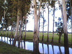
Roadside canals are very common around Pilibhit
The major part of Pilibhit District is covered by dense forest. Total 784.572km2 is forest.[18] Till 1978, 63% area of the district was a dense forest, but deforestation has reduced the total forest cover to 22.39% in 2004.[19] The Sharda canal is the main canal of the district, the others being its branches. The total length of canals in the district is 138km. Apart from the canal system, the district also has a few water bodies, which are being used for agriculture purposes.
The district Pilibhit also has several places of religious importance in or around the district. A main gurudwara of the Sikh community is located in Nanakmatta town around 46km from the city.[20][21]
Transportation
Pilibhit Junction railway station
Pilibhit Junction railway station is well connected with Bareilly Tanakpur Shahjahanpur Mailani . It is not connected with many cities of india like Agra Kanpur Mumbai Ujjain Indore Kota Jaipur Ajmer Surat Aligarh Jhansi Kathgodam Rampur Gorakhpur Varanasi Hyderabad Bangalore Chennai Ahmedabad Amritsar Chandigarh Jammu and Kashmir Etc.
Pilibhit UPSRTC Buses well connected with Bareilly Tanakpur Delhi Shahjahanpur Lucknow Lakhimpur Agra Mathura Gola . Pilibhit UPSRTC buses is not well connected with Rudrpur Dehradun Aligarh
Sports
Lalit Hari Sugar Factory Stadium
Lalit Hari Sugar Factory Stadium is mainly used for cricket. It was established in 1931. It has a matting type of pitch. This stadium had hosted a few Ranji trophy cricket matches in the early 1980s. Lalit Hari sugar factory stadium is located in the Shri Lalit Hari sugar mill compound.
Gandhi Stadium
This stadium is under control of Government. This stadium is mainly used for Hockey, Football, and Karate Training. This stadium is located on Gandhi Road so it is called Gandhi Stadium.
Various educational institutions have their Ground, including DGIC ground, St. Aloysius ground, Rama college ground, and SVM college ground. The City teams have produced many national level athletes who represented themselves at national tournaments and different events and have won a few state level and national level competitions on various events.[22]
Infrastructure
The Roads Of City Is Very Poor And The Quality Of Roads Very Very Bad Roads Of City Is Very Conjested By Which City Is Not Growing Compare To Another Cities Of India
As of the 2011 India census,[23] District Pilibhit had a population of 2,037,225. Pilibhit district is the 46th most populous Districts of Uttar Pradesh. Pilibhit City has 197,455 people. Males constitute 52.94% of the population and females 47.06%. Pilibhit has an average literacy rate of 63.58%, lower than the national average of 74.04%. Male literacy is 73.46%, and female literacy is 52.43%. In Pilibhit, 14.58% of the population is under 6 years of age.[24]
Studies reveal that the poverty level in the district is associated with the social identity, source of livelihood, landless and level of education of the head of the household. Education is a crucial instrument for raising income levels of people and moving out of the vicious circle of poverty. A study done by Delhi-based NGO, Nav Bharat Nirman indicates a strong correlation between educational attainment and poverty levels among various social classes in the district. The incidence of poverty is much higher among scheduled castes (SC) and scheduled tribes (ST) households in Pilibhit. Nearly 60 percent of SC households were below the poverty line in Pilibhit in 1999–2000. However, this proportion came down to 45.23 percent in 2007–08.[25]
Climate
Pilibhit experiences winter from November to February. It experiences pleasant windy days, clear skies and cool nights from November to the end of February. The day temperature hovers around 14°C (57°F) while night temperature is below 7°C (45°F) for most of December and January, often dropping to 3°C (37°F) or 4°C (39°F). Rain is very expected in February.[26]
According to the Imperial Gazetteer of India, Pilibhit was once known as Hafizabad after the Rohila leader of the area, Hafiz Rahmat Khan, but later took its current name from a nearby village.[29] According to a document from the British Library, 'the city Pilibhit' existed in the late 18th century (1770–1780) when Marathas invaded the Rohilkhand region. With this invasion, the Kurmi community came to this region and over time, the city Pilibhit enlarged it boundaries.[30]
Another evidence of the city's existence is found in Nepali literature, which mentions a city named as Pilibhit, which provided shelter to the last king of the Shah dynasty, Deepa Shah, who was attacked by the Gorakha king in 1789 AD.[31]
Economy
The main crop in the district is sugarcane[citation needed] and there is a sugar factory in the city.[32] According to an article published in Hindustan Times, by a 1991 estimate, 95% of India's flutes were manufactured in Pilibhit.[33] The craftsmen were used to source its bamboo from Barak Valley in Assam. Earlier, there was an unbroken narrow-gauge line running from Silchar, in Assam, via Bihar, and into Pilibhit. On this line, 60-strong bundles of bamboo, each stalk 10 ft long, used to make their way to Pilibhit, but around 15 years ago, sections of that line were removed. Now, the bamboo has to travel on the narrow gauge from Silchar to Jiribum, then shift onto a broad-gauge line to travel to Bareilly, the nearest big town, and then reloaded onto narrow gauge to come into Pilibhit.[34]
Communication and media
Pilibhit has one local Radio Station (Akashwani) at 100.1 MHz but it also receives Bareilly's FM signals of following Radio providers:
The Hindi daily newspapers include Dainik Jagran, Amar Ujala, and The Hindustan. Prominent English dailies like The Times of India, The Hindustan Times and Indian Express have fewer readers. Among lesser-known Hindi papers are Swatantra Bharat, Rashtriya Sahara, and Jansatta. The Hindi newspapers Dainik Jagran and Amar Ujala have their offices in the city.
Civic administration
The Pilibhit Nagar Palika Parishad (PNPP) is the largest municipal board in the Pilibhit district, in charge of the civic and infrastructural assets of the city of Pilibhit. This municipal board was established in 1865.[35]
Related Research Articles
Bareilly is a city in Bareilly district in the Indian state of Uttar Pradesh. It is among the largest metropolises in Western Uttar Pradesh and is the centre of the Bareilly division as well as the historical region of Rohilkhand. The city lies in the Indo-Gangetic Plains, about 252 kilometres (157 mi) northwest of the state capital, Lucknow, and 265 kilometres (165 mi) east of the national capital, New Delhi. With a population of 903,668 in 2011, it is the eighth most populous city in the state, 17th in northern India and 54th in India. It is located on the bank of Ramganga River and is the site of the Ramganga Barrage built for canal irrigation.
Shahjahanpur is a municipal corporation, town and district headquarters of Shahjahanpur District in Western Uttar Pradesh, India.
Bareilly division is one of the 18 administrative geographical unit of the northern Indian state of Uttar Pradesh. Bareilly city is the administrative headquarters of the division. Part of the Rohilkhand region, Bareilly division consists of four major districts in western Uttar Pradesh - Bareilly, Badaun, Pilibhit and Shahjahanpur.
Pilibhit district is one of the 75 districts in the state of Uttar Pradesh in India, and Pilibhit city is the district headquarters. Pilibhit district is a part of Bareilly Division. A Tiger Reserve Area was named Pilibhit Tiger Reserve in September 2008.
Shahjahanpur is a district of Uttar Pradesh India. It is a part of Bareilly division. It was established in 1813 by the British Government. Previously it was a part of district Bareilly. Geographically the main town is Shahjahanpur which is its headquarters. Its 4 Tehsils are: Powayan, Tilhar, Jalalabad and Sadar.
Lakhimpur Kheri district is the largest district in Uttar Pradesh, India, on the border with Nepal. Its administrative capital is the city of Lakhimpur.
Bisalpur is a City and a municipal board situated in the Pilibhit district of the state of Uttar Pradesh, India. The town is known for its sugar factory as well as its annual Ram Leela and Dushera festivals. Bisalpur is in between the two rivers, the West Doha River and the East Katna River. Before the formation of the new District Pilibhit, Bisalpur was under the District Bareilly. In 1913 AD after the formation of the new District Pilibhit, Bisalpur came under District Pilibhit Administration. this city is well connected with three major cities. Bisalpur is just 290 km away from the National capital New Delhi and 250 km from the state capital Lucknow. Bisalpur is famous for Annual Ramleela Fest, Dubey Taalab, Guleshwarnath Temple, Dargah Hazrat Gazi kamaal Degree college and Nagaich Market. Bisalpur is known for many things and places and the people of Bisalpur have contributed in various fields one such example is the Freedom fight Raees Mohammad who was a freedom fighter and a military man resident of Mohalla Gyaspur, he has won many medals for his extraordinary work he did for the country. He is well known for his charm and Character he played in the public domain now his generation resides in the Bisalpur mohalla gyaspur. Another important place is its railway station which has been modified for the broad gauge. This will help to get well connected with different cities of India..
Gola Gokarannath or Gola is the city, municipal board, thana and tehsil in Lakhimpur Kheri district in the Indian state of Uttar Pradesh. Gola Gokarnnath is a Hindu pilgrimage site, famous for its Gokarnnath temple. The description of this pilgrimage is also found in Hindu scriptures, lakhs of devotees come here during Sawan and Mahashivratri to have darshan of Lord Shiva.
Puranpur is a town and a municipal board in Pilibhit district in the Indian state of Uttar Pradesh. Puranpur is divided into 25 wards for which elections are held every 5 years. After independence and Partition of India the large numbers of Sikhs migrated and settled in the Puranpur Region. Due to dense Sikh population and their lifestyle, The area is also known as Mini Punjab as after Partition of India in 1947. According to Census 2011, primary population is Hindu, followed by Muslims and Christians.
Rithora is a town and a nagar panchayat in Bareilly Tehsil of Bareilly district in the Indian state of Uttar Pradesh.
Mahatma Jyotiba Phule Rohilkhand University is a State university located in the city of Bareilly in Uttar Pradesh, India. The university campus is spread over 206 acres (83 ha) on the outskirts of Bareilly city along Pilibhit bypass road and its territorial jurisdiction extends over the districts of Bareilly, Moradabad, Sambhal, Rampur, Bijnore, Amroha, Budaun, Pilibhit and Shahjahanpur in Uttar Pradesh. The university is rated A++ by the NAAC, and is categorised as a Category-1 university by UGC.
Nawabganj is a Nagar palika and an administrative subdivision of Bareilly district in the Indian state of Uttar Pradesh. A Sub Divisional Magistrate, also called Sub Divisional Officer, or pargana-adhikari is the head official.
Situated in the northern part of India, bordering with the capital of India New Delhi, Uttar Pradesh is one of the most popular and an established tourist destination for both Indians and non-Indians alike in India. The most populous state of India, Uttar Pradesh contains many historical monuments and places of religious significance. Geographically, Uttar Pradesh is very diverse, with Himalayan foothills in the extreme north and the Gangetic Plain in the centre. It is also home of India's most visited sites, Hinduism's holiest city, Varanasi. Kumbh city, Prayagraj. Kathak, one of the eight forms of Indian classical dances, originated from Uttar Pradesh. Uttar Pradesh is at the heart of India, hence it is also known as The Heartland of India. Cuisine of Uttar Pradesh like Awadhi cuisine, Mughlai cuisine and Bhojpuri cuisine are very famous not only in India but also many places abroad.
National Highway 30 is a primary national highway in India. NH 30 connects Sitarganj in Uttarakhand with Ibrahimpatnam, Vijayawada in Andhra Pradesh. The total length of this highway is 1,984.3 km (1,233.0 mi). It starts at the junction of NH 9 at Sitarganj and ends at the junction of NH 65 at Ibrahimpatnam, Vijayawada. Development of Ibrahimpatnam-Jagadalpur Route is under process. Rajdeep Rohan joint venture is the contract agency for this project. Second bridge was completed on 17 April 2024 at pilgrimage city of Bhadrachalam which is famous for temple of Lord Shri Rama. NH-30 runs through the states of Uttarakhand, Uttar Pradesh, Madhya Pradesh, Chhattisgarh, Telangana and Andhra Pradesh in India.
The Sharda River is the downstream of Kāli River that originates in the northern Uttarakhand state of India in the Great Himalayas on the eastern slopes of Nanda Devi massif, at an elevation of 3,600 m (11,800 ft) in the Pithoragarh district. It then flows between the Nepal and India border. Descending, it enters the Indo-Gangetic Plain at Brahmadev Mandi in Nepal, where it expands above the Sharda Barrage. From that point onward, it is known as the Sharda River. The river proceeds southeastward into India through northern Uttar Pradesh before merging with the Ghaghara River southwest of Bahraich, covering a distance of approximately 300 miles (480 km).
Western Uttar Pradesh is a region in India that comprises the western districts of Uttar Pradesh state, including the areas of Rohilkhand and those where Hindi, Urdu and Braj are spoken; it is in the region of Western Uttar Pradesh that Hindi-Urdu originated. The region has some demographic, economic and cultural patterns that are distinct from other parts of Uttar Pradesh, and more closely resemble those of Haryana and Rajasthan states. The largest city of the region is Ghaziabad, while the second-largest city, Agra, is a major tourist destination.
The Habura are a Hindu caste found in the state of Uttar Pradesh, India.
Bareilly Junction railway station is a railway station serving Bareilly city in Uttar Pradesh. It is an important station as well as the headquarters of Izzatnagar railway division of the North Eastern Railway zone & Moradabad railway division of the Northern Railway zone. It lies on Lucknow–Moradabad line and Lucknow-Sitapur-Lakhimpur-Pilibhit-Bareilly-Kasganj Line provides a stop for most trains passing through. Bareilly Junction used to serve both broad and metre gauge, Bareilly Junction was connected to Lucknow by both Broad Gauge and Meter Gauge, Broad Gauge was connected to Lucknow via Tilhar, Shahjahanpur, Hardoi. On the other hand Meter Gauge was connected to Lucknow via Pilibhit-Mailani-Lakhimpur-Sitapur, but now the metre gauge is converted into broad gauge.
This railway station is reconstructed and completed in January 2023 Shaktinagar Terminal railway station is a small railway station in Sonbhadra, Uttar Pradesh. Its code is SKTN. It serves the town of Shaktinagar, but the station consists of only one platform and lacks facilities including running water, sanitation and shelter. The station is connected to major cities such as Chopan, Robertsganj, Mirzapur, Allahabad, Rae Bareli, Lucknow, Bareilly, Pilibhit, Tanakpur and Varanasi.
Chopan railway station is a major railway station located in the Sonbhadra district of the Indian state Uttar Pradesh which primarily serves Chopan town and its surrounding areas. The station consists of five platforms and the platforms are well sheltered and well equipped with all the basic amenities.
↑ "Population under poverty line". A N Sinha Institute of Social Studies. Archived from the original on 16 December 2013. Retrieved 21 July 2007.{{cite web}}: CS1 maint: unfit URL (link)
↑ "Population Under Poverty Line". A N Sinha Institute of Social Studies. Archived from the original on 16 December 2013. Retrieved 21 July 2007.{{cite web}}: CS1 maint: unfit URL (link)
P. C. Kanjilal, P (1982). "A Forest Flora for Pilibhit, Oudh, Gorakhpur, and Bundelkhand" (5ed.). Narendra Pub. House.{{cite journal}}: Cite journal requires |journal= (help)
Govt. of Uttar Pradesh, P (1959). "Uttar Pradesh District Gazetteers" (2ed.). Govt. of Uttar Pradesh.{{cite journal}}: Cite journal requires |journal= (help)
Walter C. Neale, P (1962). "Economic Change in Rural India: Land Tenure and Reform in Uttar Pradesh:1800–1955" (1ed.). Yale University Press.{{cite journal}}: Cite journal requires |journal= (help)
Ira Klein, P (1974). "Population and Agriculture in Northern India, 1872–1921" (1ed.). Cambridge University Press.{{cite journal}}: Cite journal requires |journal= (help)
This page is based on this Wikipedia article Text is available under the CC BY-SA 4.0 license; additional terms may apply. Images, videos and audio are available under their respective licenses.


