Dholpur is a city in the Dholpur district in Rajasthan state of India. It is situated on the left bank of the Chambal river. The city is the administrative headquarters of Dholpur district. Dholpur was established by King Dhaval Dev of the Tomar dynasty of Delhi Tomaras of Delhi in 1004 AD by the name of Dhavalpuri, later with time it was changed to the present day name Dholpur.
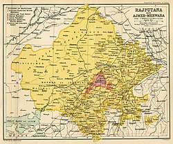
Dholpur became a separate district in 1982 comprising Dholpur, Rajakhera, Saramathura, Bari and Baseri tehsils. Dholpur district is a part of Bharatpur Division/Commissionerate. It is bordered by Bharatpur district of Rajasthan to the North and Agra District of Uttar Pradesh to the north and north east, Morena District of Madhya Pradesh to the south, Karauli district to the west and Uttar Pradesh and Madhya Pradesh to the east. Dholpur is situated 27km from Morena, 55km from Agra and 66km from Gwalior.
Dholpur is famous for its red stone and ancient temple. Also, Machkund temple and kund which is famous as "Tirthon ka Bhanja". Three famous shiv temples situated here are Mahakaal Shiv Temple, Mahadev Temple at the nearby Parvati river, and Bhooteshwar Mahadev Temple.
Geography
The city of Dholpur (Dhaulpur) lies on the left (north) bank of the Chambal River at 26° 42' 0" North, 77° 54' 0" East,[4] across the river, and provincial border, from Morena in Madhya Pradesh. It is located on old NH-3 and is a junction on the North Central Railway. The total area of Dholpur city is 33.3 square kilometres (12.9sqmi).[1]
The earliest Rajput dyanasty that ruled Dholpur region were the Chauhans in the early 7th and 8th century.[7] The discovery of a stone inscription at Dholpur has brought into light the existence of a Chahamana dynasty at Dhavalapuri.[8] The inscription mentions Chauhan Prince Chandamahasena who was the contemporary of Pratihara emperor Bhojadev.[9] The inscription mentions conflicts of Chauhan Prince with invading Arab armies.[10]
Dholpur was taken by Sikandar Lodi in 1491, who handed it to a Muslim governor in 1504. After the death of Ibrahim Lodi, many states declared themselves independent. Talai Khan became the ruler of Gwalior.
After the Mughals, Dholpur was taken successively by the Jat ruler Maharaja Suraj Mal of Bharatpur;from period of 1705 to 1761 the fort was under Chauhan rajputs' sub-clan Bhadoriya and later regained by different rulers like Mirza Najaf Khan in 1775; by the MarathaScindia ruler of Gwalior in 1782; and finally, by the British East India Company in 1803. It was restored by the British to the Scindias under the Treaty of Sarji Anjangaon, briefly, and was soon reoccupied by the British. In 1805, Dholpur came under the Jat ruler, Maharana Kirat Singh of Gohad, a princely state, a vassal of the British during the Raj.[13][14]
According to the Babur Nama, Babur had a baori built in Dholpur on his last trip to Gwalior, to add to the charghar ("four-gardens") he had already had built there.[15]
As of the[update]2011 census, Dholpur municipality had a population of 126,142[17] and the urban agglomeration had a population of 133,229.[3] The municipality had a sex ratio of 862 females per 1,000 males and 13.6% of the population were under six years old.[17] The effective literacy was 76.56%; male literacy was 84.22% and female literacy was 67.74%.[17]
Dholpur Military School is housed in Kesarbagh Palace, a magnificent mansion of the former ruler of the erstwhile Dholpur State. It is 10.5 kilometers away from Dholpur City and on Dholpur-Bari Road.
Govt PG College is located two kilometers away from the city towards the railway station. The PG college in Dholpur city was established four decades ago after independence. Notable alumni include DP Sharma, International Digital Diplomat and National Brand Ambassador, Swachh Bharat Mission, India, and Manoj Rajoria, Member of Parliament, Republic of India.
Climate
Dholpur is reputed to be the location of the highest recorded temperature in India, at 50°C on 3 June 2017. The hottest months are May and June, which mark the oppressive summer season. Temperatures in summers are normally higher than 40°C. Coldest months are December and January where temperatures sometimes reach near-zero and subzero levels. The lowest recorded temperature is -4.3°C on 29 January 2017.[19] Annual average rainfall is 860mm.
Climate data for Dholpur (1981–2010, extremes 1955–2012)
↑Ramusack, Barbara N. “Like their Phulkian counterparts, the Hindu Jat rulers of Bharatpur and Dholpur claimed Rajput origins. The ruling family of Bharatpur, located southeast of Delhi, reputedly forfeited its Rajput status when an ancestor Bal Chand, having no children by a Rajput wife, produced sons with a Jat woman.” (8 January 2004). The Indian Princes and their States. Cambridge University Press. ISBN978-1-139-44908-3.{{cite book}}: CS1 maint: multiple names: authors list (link)
↑Shashi, Shyam Singh (1996). Encyclopaedia Indica: Princely States in Colonial India. Encyclopaedia Indica: India, Pakistan, Bangladesh. Vol.168. Anmol Publications. p.52. ISBN9788170418597.
↑Mahotsav, Amrit. "Battle of Dholpur in 1803". amritmahotsav.nic.in Government of India. "At the same time, the British also helped the Jats led by Rana Kirat Singh, to win the Gohad region from the Scindias. As part of an arrangement made by the Company, Rana Kirat Singh was given Dholpur and the former took over Gohad. Thus, the Dholpur state was formed and Rana Kirat Singh was declared its ruler in 1805."
This page is based on this Wikipedia article Text is available under the CC BY-SA 4.0 license; additional terms may apply. Images, videos and audio are available under their respective licenses.