Bari, India

Last updated

Bari
city
India Rajasthan location map.svg
Red pog.svg
Bari
Location in Rajasthan, India
India location map.svg
Red pog.svg
Bari
Bari (India)
Coordinates: 26°38′N77°37′E / 26.63°N 77.62°E / 26.63; 77.62
CountryFlag of India.svg  India
State Rajasthan
District Dholpur
Elevation
463 m (1,519 ft)
Population
 (2014)
  Total62,721
Languages
  Official Hindi
Time zone UTC+5:30 (IST)
PIN
328021
ISO 3166 code RJ-IN
Vehicle registration RJ-
Fort Bari, baadd'ii kaa kilaa Forte Bari.jpg
Fort Bari, बाड़ी का किला
Khanpur Mahal Khanpur Mahal.jpg
Khanpur Mahal
Kaila Mata temple Bari Kaila Mata temple.jpg
Kaila Mata temple Bari
Railway station Bari,railway station.jpg
Railway station
Khanpur Mahal Khanpur Mahal.jpg
Khanpur Mahal
Kaila Mata temple Bari Kaila Mata temple.jpg
Kaila Mata temple Bari

Bari is a city and a municipality in Dholpur district in the state of Rajasthan, India. Bari came into existence as a Pargana of princely state of Dholpur during the rule of Rana Ram Singh of Dholpur.

Contents

During his rule the state was divided into six parganas namely, 1. Dholpur, 2. Rajakheda, 3. Badi, 4. Basaidi, 5. Mania and 6. Kulari

Bari subdivision is well known for its excellent sandstone. Historically, this red stone was used for local construction like Bari fort, Talab-E-Shahi, Jublee hall Dholpur, Dholpur palace, Nihal tower (cloak tower) Dholpur and most of other local structures. The world-famous national monuments which are in list of UNESCO world heritage site in India are also made up of Dholpur red stone which is extracted from Bari area in capital Delhi, like the Delhi Red Fort, Humayun Tomb (Humayun ka Maqbara) located in Nizamuddin, East Delhi.

Bari red stone was used in rebuilding of Agra Fort by Akbar. This red sandstone was extracted from Barauli, a village in Bari subdivision.

The modern and future monument The Swaminarayan Akshardham (Delhi) Temple in New Delhi, is constructed entirely from Rajasthani pink sandstone. The architect of modern Delhi, Edwin Lutyens, a major 20th century British architect who is known for imaginatively adapting traditional architectural style, had a special liking for this stone, and the Rashtrapati Bhavan exemplifies the use of Dholpur stone in monumental architecture. [1]

Geography

Bari is located at Latitude: 26°38'58.77"N and Longitude : 77°37'2.58"E Tourist attractions

Talab-E-Shahi and Khanpur Mahal

Talab-e-Shahi is one of the cleanest and thriving lakes in Rajasthan today. Located 27 km from Dholpur district headquarters and 5 km from Bari in Rajasthan, this lake and the 17th century Khanpur Mahal next to it were primarily made to serve Emperor Shah Jahan during his hunting sojourns to Dholpur. Khanpur Mahal, a palace of several connected pavilions, though, was made as Shah Jahan’s pleasure residence, it could never serve its purpose. Both the lake as well as the palace was made in the year 1617. The richness and ambiance of the lake beckons a number of winter migratory birds like the pintail, tufted duck, common teal, garganery teal. etc. After Shah Jahan’s demise, the local royal family took over the reins of the palace. At present this building is headquarters of Bari area RAC (police).

Ram Sagar and Van Vihar Wildlife Sanctuary

Spread about 60 sq km area, Van Vihar sanctuary is divided into two parts Van Vihar and Ramsagar. There are two separate wildlife sanctuaries. Van Vihar is situated on Vindhyan plateau and is inhabited by animals like Sambar (deer), Chital, blue bull, wild bear hyena and leopard. The sanctuary is surrounded by Dhok and Khair trees.

The Dholpur-Bari Train

DBLR Train Bari Train.jpg
DBLR Train

The Dholpur-Bari Light Railway (DBLR) was a 2' 6" narrow gauge line (among 23 notable narrow gauge railways). Previously owned and managed by the Dholpur Durbar.
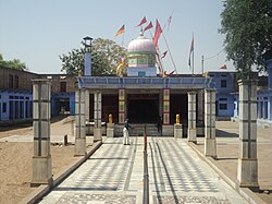
Bhuteswar temple

This is a famous and Holy temple of lord Shiva, on the bank of Parvati river, 10 km from Bari, on the Bari-Baseri road. This is very old temple of Bari Baseri Area, thousands of people visit this temple every month, there are regular picnic and feast (bhoj) programmes organized regularly, on the opposite riverbank stands the Panchmukhi Hanuman temple, this temple is near the river.

Sant Nagar

Shri Param Hans Advait Mat Sant Nagar is a Hindu temple. Advait Mat was a cluster of movements in northern India that perceive themselves to be originating from Totapuri in the 18th century Shri Paramhans Advait Math made its advent over a hundred years ago to spread and preach truth, ideals of Bhakti, Karam Yoga, and spiritual knowledge.

This is a very peaceful and disciplined temple where all saints (Sadhu, Mahatma) produce their food vegetable and milk by self-management (Karmayoga), in temple land which is surrounded by large boundary wall, they are independent by economy. There is very nice garden and temple inside the boundary, the temple is opened for visit from 8Am to 5Pm on regular interval for general public,This temple Provides social services by a charitable hospital free of cost to poor citizens.

Damoh,(दमोह)

This is a waterfall in Sarmathura region, Placed a distance of 35 kilometer from Bari. It is the attractive tourist destination in whole district. It is visible in rainy season [July–September]. Besides this, Damoh (Dhamoye) has a long and green forest range with wild animals. Tiger Mohan from Ranthambore National Park, whenever escapes from Ranthambhor likes the forest territory of Dhamoh and van vihar in Dholpur.

Demographics

The Bari Municipality has population of 62,721 of which 33,673 are males while 29,048 are females as per report released by Census India 2011. Literacy rate of Bari city is 70.75% higher than state average of 66.11%. In Bari, Male literacy is around 79.38% while female literacy rate is 60.79%. Population of Children with age of 0-6 is 10102 which is 16.11% of total population of Bari (M). In Bari Municipality, Female Sex Ratio is of 863 against state average of 928. Moreover, Child Sex Ratio in Bari is around 847 compared to Rajasthan state average of 888. there is only one girls school for senior education. Out of total population, 18,730 were engaged in work or business activity. Of this 16,057 were males while 2,673 were females. In census survey, worker is defined as person who does business, job, service, and cultivator and labour activity. Of total 18730 working population, 88.05% were engaged in Main Work while 11.95% of total workers were engaged in Marginal Work.

Related Research Articles

<span class="mw-page-title-main">Rajasthan</span> State in Northwestern India

Rajasthan is a state in northern India. It covers 342,239 square kilometres (132,139 sq mi) or 10.4 per cent of India's total geographical area. It is the largest Indian state by area and the seventh largest by population. It is on India's northwestern side, where it comprises most of the wide and inhospitable Thar Desert and shares a border with the Pakistani provinces of Punjab to the northwest and Sindh to the west, along the Sutlej-Indus River valley. It is bordered by five other Indian states: Punjab to the north; Haryana and Uttar Pradesh to the northeast; Madhya Pradesh to the southeast; and Gujarat to the southwest. Its geographical location is 23°.3' to 30°.12' North latitude and 69°.30' to 78°.17' East longitude, with the Tropic of Cancer passing through its southernmost tip.

<span class="mw-page-title-main">Agra</span> Metropolis in Uttar Pradesh, India

Agra is a city on the banks of the Yamuna river in the Indian state of Uttar Pradesh, about 230 kilometres (140 mi) south-east of the national capital Delhi and 330 km west of the state capital Lucknow. With a population of roughly 1.6 million, Agra is the fourth-most populous city in Uttar Pradesh and twenty-third most populous city in India.

Ratlam is a city in the northwestern part of the Malwa region in Madhya Pradesh state of India. The city of Ratlam lies 480 metres (1,570 ft)above sea level. It is the administrative headquarters of Ratlam district, which was created in 1947 after the independence of India. It is located 294 kilometres west of the state capital Bhopal.

<span class="mw-page-title-main">Agra Fort</span> Historic site in Uttar Pradesh, India

The Agra Fort is a historical fort in the city of Agra, and also known as Agra's Red Fort. Mughal emperor Humayun was crowned at this fort. It was later renovated by the Mughal emperor Akbar from 1565 and the present-day structure was completed in 1573. It served as the main residence of the rulers of the Mughal dynasty until 1638, when the capital was shifted from Agra to Delhi. It was also known as the "Lal-Qila" or "Qila-i-Akbari". Before being captured by the British, the last Indian rulers to have occupied it were the Marathas. In 1983, the Agra fort was inscribed as a UNESCO World Heritage Site because of its importance during the Mughal Dynasty. It is about 2.5 kilometers (1.6 mi) northwest of its more famous sister monument, the Taj Mahal. The fort can be more accurately described as a walled city. It was later renovated by Shah Jahan.

<span class="mw-page-title-main">Jama Masjid, Delhi</span> 17th Century Mosque in Delhi, India

Masjid-i-Jehan-Numa, commonly known as the Jama Masjid of Delhi, is one of the largest mosques in India.

<span class="mw-page-title-main">Mughal garden</span> South Asian style of garden

Mughal gardens are a type of garden built by the Mughals. This style was influenced by the Persian gardens particularly the Charbagh structure, which is intended to create a representation of an earthly utopia in which humans co-exist in perfect harmony with all elements of nature.

<span class="mw-page-title-main">Sasaram</span> City in Bihar, India

Sasaram, also spelled as Sahasram, is a historical city and a municipal corporation region in the Rohtas district of Bihar state in eastern India.

<span class="mw-page-title-main">Mughal architecture</span> 16th–18th-century Indo-Islamic architecture

Mughal architecture is the type of Indo-Islamic architecture developed by the Mughals in the 16th, 17th and 18th centuries throughout the ever-changing extent of their empire in the Indian subcontinent. It developed from the architectural styles of earlier Muslim dynasties in India and from Iranian and Central Asian architectural traditions, particularly Timurid architecture. It also further incorporated and syncretized influences from wider Indian architecture, especially during the reign of Akbar. Mughal buildings have a uniform pattern of structure and character, including large bulbous domes, slender minarets at the corners, massive halls, large vaulted gateways, and delicate ornamentation; examples of the style can be found in modern-day Afghanistan, Bangladesh, India and Pakistan.

<span class="mw-page-title-main">Dholpur</span> City in Rajasthan, India

Dholpur is a city in the Dholpur district in Rajasthan state of India. It is situated on the left bank of the famous Chambal river. The city is the administrative headquarters of Dholpur District and was formerly seat of the Dholpur princely State of Jats.

<span class="mw-page-title-main">Hindaun</span> City in Rajasthan, India

Hindaun is a city and municipality, near city of Karauli in Karauli district, Rajasthan, India. It has a population of 105690 and is governed by a municipal council.

<span class="mw-page-title-main">Indo-Islamic architecture</span> Islamic architecture in Indian subcontinent

Indo-Islamic architecture is the architecture of the Indian subcontinent produced by and for Islamic patrons and purposes. Despite an initial Arab presence in Sindh, the development of Indo-Islamic architecture began in earnest with the establishment of Delhi as the capital of the Ghurid dynasty in 1193. Succeeding the Ghurids was the Delhi Sultanate, a series of Central Asian dynasties that consolidated much of North India, and later the Mughal Empire by the 15th century. Both of these dynasties introduced Islamic architecture and art styles from West Asia into the Indian subcontinent.

<span class="mw-page-title-main">Dholpur district</span> District of Rajasthan in India

Dholpur District is a district of Rajasthan state in Northern India. The town of Dholpur is the district headquarters. Dholpur District is a part of Bharatpur Divisional Commissionerate. It was carved out from the erstwhile Bharatpur District on 15 April 1982.

<span class="mw-page-title-main">Stones of India</span>

India possesses a wide spectrum of dimensional stones that include granite, marble, sandstone, limestone, slate, and quartzite, in various parts of the country.

<span class="mw-page-title-main">Pihani</span> Town in Uttar Pradesh, India

Pihani is a town and nagar palika parishad in Hardoi district of Uttar Pradesh, India. Historically, the city was a centre of sword production, leading to at least one British writer calling it "the Damascus of Oudh". Today, important industries in Pihani include jaggery and woven carpets. As of 2011, the town's population is 36,014, in 5,626 households. Pihani also serves as the headquarters of a community development block in Shahabad tehsil.

Sohna is a town and a Municipal Council in the Gurgaon district of Haryana, India. A popular tourist weekend and conference retreat, it is on the highway from Gurgaon to Alwar near a vertical rock. Sohna is known for its hot springs and Shiva temple. Sohna tehsil is part of Ahirwal Region. Major communities in Sohna are Rajputs, Ahirs, Gujars, Jats, and Muslim Gujjar. Gurgaon district is divided into 4 sub-divisions each headed by a Sub-Divisional Magistrate (SDM): Gurgaon, Sohna, Pataudi and Badshahpur.

<span class="mw-page-title-main">Gates of Delhi</span>

The Gates of Delhi were city gates at various medieval townships around Delhi, built under dynastic rulers in the period that could be dated from the 8th century to the 20th century. They are the gates in:

<i>Persian Inscriptions on Indian Monuments</i> Book by Hekmat E Shirazi

Persian Inscriptions on Indian Monuments is a book written in Persian by Dr Ali Asghar Hekmat E Shirazi and published in 1956 and 1958 and 2013. New edition contains the Persian texts of more than 200 epigraphical inscriptions found on historical monuments in India, many of which are currently listed as national heritage sites or registered as UNESCO world heritage, published in Persian; an English edition is also being printed.

<span class="mw-page-title-main">Sarmathura</span> Town in Rajasthan, India

Sarmathura is a subdivision located in Dholpur district, in the Indian state of Rajasthan.

<span class="mw-page-title-main">Tomb of Isa Khan</span> Mausoleum in Delhi, India

The tomb of the noble Isa Khan Niazi is located in the Humayun's Tomb complex in Delhi, India. The mausoleum, octagonal in shape and built mainly of red sandstone, was built in 1547–1548 during the reign of Sher Shah Suri. The mosque of Isa Khan is located west of the mausoleum, which along with other buildings form the UNESCO World Heritage Site of Humayun's tomb complex.

References

https://web.archive.org/web/20110210053922/http://www.indiaspecialist.co.in/dholpur.html

http://www.irfca.org/articles/manning/dholpur.html Archived 12 November 2017 at the Wayback Machine

http://issuu.com/aecworldxp/docs/stone_trail