Karauli district | |
---|---|
Country | India |
State | Rajasthan |
Division | Bharatpur |
Headquarters | Karauli |
Government | |
• District collector | Sh. Siddharth Sihag, I.A.S. |
Area | |
• Total | 5,043 km2 (1,947 sq mi) |
Population (2011) [1] | |
• Total | 1,458,248 |
• Density | 290/km2 (750/sq mi) |
Demographics | |
• Literacy | 66.22 |
• Sex ratio | 861 |
Languages | |
• Official | Hindi, Rajasthani |
• Native | Rajasthani, Braj Bhasha dialect |
Time zone | UTC+05:30 (IST) |
Website | www |
Karauli District is a district of the state of Rajasthan in western India. It is located in the Braj Bhoomi region. The town of Karauli serves as the administrative headquarters of the district. Karauli district also comes under the Bharatpur Divisional Commissionerate.
The population of Karuali district was 1,458,248 people in the 2011 Indian census, giving a population density of 264 inhabitants per square kilometre (680/sq mi). [1]
Karauli District encompasses an area of 5,043 square kilometres (1,947 sq mi). It is bordered by Dholpur district to the east, Bharatpur district to the northeast, Dausa district to the north, and Sawai Madhopur district to the west. [2] Karauli City is located 169 km (105 mi) from Gwalior, 114 km (71 mi) west of Agra and 158 km (98 mi) from the city of Jaipur.
The Chambal River forms the southeastern boundary of the district with the state of Madhya Pradesh, around 5 kilometres (3.1 mi) away from Mandrayal. Although most of Karauli district is composed of hills and valleys, there are no high mountains, with the highest having an elevation less than 450 metres (1,480 ft) above sea level. [2]
The district also has a forest which covered an area of 172,459 hectares (426,160 acres) in 2011, about 30% of the total geographical area of the district's 504,301 ha (1,246,150 acres).
Natural resources found in Karauli district include sandstone, masonry stone, silica sand, soapstone, white clay and some iron ore.[ citation needed ]
Karauli district's natural environment includes the Vindhya Range and Aravalli Range. The district has both plains and hilly areas. [3] The plains are fertile and the soil present in the area is lightweight and sandy. There are many rivers in the district.
The climate in Karauli district is sunny for most of the year, with the average annual high 35 °C (95 °F) and low 23 °C (73 °F). Extreme temperatures have reached 49 °C (120 °F) in May and 2 °C (36 °F) in January. [4] The humidity of Karauli district ranges from 31% to 35% in the dry season with a dew point between 11 °C (52 °F) and 15 °C (59 °F). The annual rainfall is 668.86 mm (26.333 in), falling for an average of 35 days per year, concentrated during the South Asian Monsoon from June to September.
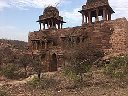
Karauli City is the district headquarters of Karauli district, which is divided into eight tehsils, six subdivisions, 223 Panchayats, 881 villages, six Panchayat Samiti, two Nagar Parishad, and one Nagarpalika.
In 2006, the Ministry of Panchayati Raj named Karauli district one of the country's 250 most impoverished districts (out of a total of 640 districts). [5] It is one of the twelve districts in Rajasthan currently receiving funds from the Backward Regions Grant Fund Programme (BRGF). [5]
Year | Pop. | ±% p.a. |
---|---|---|
1901 | 298,215 | — |
1911 | 295,899 | −0.08% |
1921 | 266,079 | −1.06% |
1931 | 292,829 | +0.96% |
1941 | 330,914 | +1.23% |
1951 | 370,984 | +1.15% |
1961 | 443,169 | +1.79% |
1971 | 557,132 | +2.31% |
1981 | 718,715 | +2.58% |
1991 | 924,715 | +2.55% |
2001 | 1,205,888 | +2.69% |
2011 | 1,458,248 | +1.92% |
source: [6] |
In the 2011 census of India, Karauli district had a population of 1,458,248, [1] roughly equal to the nation of Eswatini [7] or the US state of Hawaii. [8] This makes it the 340th most populous district in India. [1] The district has a population density of 264 inhabitants per square kilometre (680/sq mi). [1] Its population growth rate from 2001 to 2011 was 20.57%. [1] Karauli has a sex ratio of 858 females for every 1000 males, [1] and a literacy rate of 67.34%. 14.96% of the population lives in urban areas. [1]
The Jat and Yadav castes both have a significant population in Karauli. [9]
After the separation of Todabhim and Nadoti tehsils, the resulting district had a population of 1,056,170. The district had a sex ratio of 858 females per 1000 males. 195,128 people (18.48% of the population) lived in urban areas. Scheduled Castes and Scheduled Tribes made up 267,102 (25.29%) and 209,289 (19.82%) of the population respectively. [1] Hindi is the predominant language, spoken by 99.41% of the population. [11]
Karauli is a city located in the Indian state of Rajasthan. It is located in the Braj region and holds religious importance in Hinduism. The city is the administrative center of Karauli District, and was formerly the capital of the erstwhile princely state of Karauli. Karauli District comes under Bharatpur Divisional Commissionerate.
Hindaun is a city and municipality, near city of Karauli in Karauli district, Rajasthan, India. It has a population of 105690 and is governed by a municipal council.
Sawai Madhopur district is a district of Rajasthan state in north-west India. Sawai Madhopur is the chief town and district headquarters. Sawai Madhopur district comes under Bharatpur division.
Firozabad district is one of the western districts of the Indian state of Uttar Pradesh, which has Firozabad city as its district headquarters. The district is a part of the Agra division.
Bharatpur District is a district in Rajasthan state in western India. The city of Bharatpur is the District Headquarters, Division Headquarters and Headquarters of Bharatpur Police Range of Rajasthan Police. Bharatpur District is a part of National Capital Region of India Delhi.
Dholpur District is a district of Rajasthan state in Northern India. The town of Dholpur is the district headquarters. Dholpur District is a part of Bharatpur Divisional Commissionerate. It was carved out from the erstwhile Bharatpur District on 15 April 1982.
Asind is a city and a municipality in Bhilwara district, Rajasthan, India. It is a Tehsil (sub-division) for many villages The city have a magistrate office, lower justice court and many administrative hub for many major villages.
Todabhim is a city and a "municipality" in Gangapur City district in the Indian state of Rajasthan. It is headquarters of Todabhim sub division, tehsil and C&RD block of Gangapur City district.
Kaila Devi Temple is a Hindu temple situated in Kailadevi village of Karauli district, in the Indian state of Rajasthan.
Binega or Vinega is a small village/hamlet located approximately 8 km (5 mi) from Gangapur City in Sawai Madhopur District of Rajasthan, India. It comes under Toksi Panchayath. It belongs to Bharatpur Division. It is located 73 km towards north from district headquarters Sawai Madhopur and 120 km from state capital Jaipur
Pratapgarh district is the 33rd district of Rajasthan, created on 26 January 2008. It is a part of Udaipur Division and has been carved out from the erstwhile tehsils of Chittorgarh, Udaipur and Banswara districts. Pratapgarh town is the administrative headquarters of the district.
Shri Mahavir Ji is an important and prominent Jain pilgrimage site situated in Shri Mahaveerji town in Hindaun Block, Karauli district in Rajasthan. Given the importance of the religious place, the Indian Railways has specifically developed a railway station under West Central Railway zone by the name of Shri Mahaveerji railway station which is 10 minutes drive from the temple and temple authorities have arranged for regular buses from the station to the temple. The temple is visited by millions of Jain and Hindu devotees every year.
Gunadal is a panchayat village in the state of Karnataka, India. Administratively it is under Bijapur Taluka of Bijapur district, Karnataka. Located in the far southwestern corner of the district, Gunadal is nearly 45 km by road from the district headquarters, the city of Bijapur. In Gunadal there is a Government Ayurvedic Hospital, Government Veterinary Hospital, Post Office, Police Station and gram panchayat headquarters.
Hindaun City railway station is a railway station serving Hindaun City in the state of Rajasthan, India. It comes under the Kota railway division of West Central Railway zone. Hindaun City is a B-Grade station on the Delhi–Mumbai route.
Hindaun City Bus Depot is a Rajasthan Roadways Bus Depot in Hindaun, Rajasthan, India. It is the central bus stand for the Rajasthan State Road Transport Corporation. Buses are available for Jaipur, Kaila Devi, Gangapur City, Dausa, Sawai Madhopur, Ajmer, Udaipur, Etawah, Bharatpur, Dholpur, Alwar, Tonk, Churu, Jhunjhunu, Bikaner, Delhi, Haryana, Punjab, Uttarakhand, Gujarat, Uttar Pradesh, Madhya Pradesh and various other locations.
Hindaun is a Block in Karauli district of the Indian state of Rajasthan in Northern India. It is a subdivisional headquarter. Its population is approximately 442,000. The block covers an area of 700 Square kilometres, which makes it the biggest block in Karauli. The subdistrict code of Hindaun Block is 00522. There are about 165 villages in Hindaun Block.
Shri Mahaveer Ji is a town and tehsil headquarter in Hindaun Block, Karauli District, Rajasthan. Approximately 20,000 people live there, and Many villages come within its area. A hydrological station is installed at the town.
Fateh Singhpura is a railway station on the West Central railway network at Suroth, Suroth Tehsil in India. It comes under the Kota railway division of West Central Railway zone Fatehsinghpura is a D-Grade station on the Delhi–Mumbai route.
Shri Raghunath Ji Temple is a Hindu temple. It is the ancient temple of Hindaun City. The temple is approximately 650 year old. The temple is located at Tulsipura near Nakkash Ki Devi - Gomti Dham
Baragama is a village in Hindaun Tehsil, Karauli district, Rajasthan, India, and forms a part of Bharatpur Division. It is located 34 km (21 mi) north of the district headquarters at Karauli, 7 km (4.3 mi) from Hindaun and 131 km (81 mi) from the state capital at Jaipur.
Swaziland 1,370,424
Hawaii 1,360,301