Sheopur district

Last updated

Sheopur District
Kuno river.jpg
MP Sheopur district map.svg
Location of Sheopur district in Madhya Pradesh
Coordinates(Sheopur): Coordinates: 25°42′N76°42′E / 25.7°N 76.7°E / 25.7; 76.7
CountryFlag of India.svg  India
State Madhya Pradesh
Division Chambal
Headquarters Sheopur
Tehsils 1. Sheopur 2. Vijaypur, 3. Karahal, 4. Birpur,
5. Badoda
Government
   Collector & District Magistrate Shri Shivam Verma IAS
   Lok Sabha constituencies Morena (shared with Morena district)
   Vidhan Sabha constituencies 1. Sheopur, 2. Vijaypur
Area
  Total6,606 km2 (2,551 sq mi)
Population
 (2011)
  Total687,861
  Density100/km2 (270/sq mi)
Demographics
   Literacy 58.0
  Sex ratio902
Time zone UTC+05:30 (IST)
Vehicle registration MP 31
Website sheopur.nic.in/en/

Sheopur District is a district of Madhya Pradesh state in central India. The district is located in the north of the state and forms part of Chambal division. It is situated on the periphery of Rajasthan, which shows in the influence of Rajasthani culture in this district.

Contents

The town of Sheopur is the district headquarters. Other towns include Bijeypur, Karahal and Badoda. The district has a population of 687,861 (2011 census) and covers an area of 6,606 km². [1] It is the third least populous district of Madhya Pradesh (out of 50), after Harda and Umaria. [2] It is one out of 21 tribal districts of Madhya Pradesh. [3]

Geography

Sheopur district is located in the north of Madhya Pradesh in the Chambal division. It is bordered by Morena district to the north, Gwalior district to the east, Shivpuri district to the southeast, and Rajasthan to the south and northwest.

The region is chiefly marked by the presence of the Chambal ravines - the Chambal river marks the border with Rajasthan. Southeast of the Chambal is a plateau region which leads to a range of forested hills in the east of the district where lies Kuno Wildlife Sanctuary.

History

The town of Sheopur and its fort was said to have been founded by Indra Singh of the Gaur Rajputs, feudatories of Jaipur, in 1537. The first historical mention of the region occurs thanks to Nimat Ullah, who recorded an expedition of SIkander Lodhi in support of Raj Dungar who later converted to Islam. Sheopur surrendered to Akbar when he was advancing towards Chittor. Later it was made headquarters of a mahal in Ranthambore Sarkar. In 1808, it was conquered by Daulat Rao Scindia of Gwalior who gave it to his general Jean Baptiste Filose as a jagir. Filose managed to starve out the Gaurs remaining in the fort, who left in 1809. Under Daulat Rao, the town was a mint. While Filose was raiding adjoining territory of Jai Singh of Raghogarh, Singh captured the fort and his family. After 1818, Filose retired to Sheopur as his jagir. Sheopur continued as a part of Gwalior state until 1947 when it became part of independent India. In 1956, it was merged with the remainder of Madhya Pradesh. Sheopur district was carved out of Morena District in 1998. [4]

Economy

In 2006 the Ministry of Panchayati Raj named Sheopur one of the country's 250 most backward districts (out of a total of 640). [5] It is one of the 24 districts in Madhya Pradesh currently receiving funds from the Backward Regions Grant Fund Programme (BRGF). [5]

Divisions

The district comprises three sub-divisions: Sheopur, Vijaypur and Karahal. Sheopur sub-division consists two tehsils: Sheopur and Baroda. Vijaypur sub-division also comprises two tehsils: Vijaypur and Veerpur. Karahal sub-division comprises the lone tehsil of Karahal. There are two nagar palikas in this district: Sheopur and Baroda and a nagar panchayat, Vijaypur.

There are two Vidhan Sabha constituencies in this district, namely, Sheopur and Vijaypur. Both of these are part of Morena Lok Sabha constituency. [6]

Demographics

According to the 2011 census Sheopur District has a population of 687,861, [2] roughly equal to the nation of Equatorial Guinea [7] or the US state of North Dakota. [8] This gives it a ranking of 505th in India (out of a total of 640). [2] The district has a population density of 104 inhabitants per square kilometre (270/sq mi) . [2] Its population growth rate over the decade 2001-2011 was 22.96%. [2] Sheopur has a sex ratio of 902 females for every 1,000 males, [2] and a literacy rate of 58.02%. Scheduled Castes and Tribes made up 15.8% and 23.5% of the population respectively. Scheduled Castes and Scheduled Tribes make up 15.76% and 23.47% of the population respectively. The Sahariya are the main tribe in the area. [2]

Religions in Sheopur district (2011) [9]
ReligionPercent
Hinduism
92.85%
Islam
6.02%
Sikhism
0.93%
Other or not stated
0.20%

Languages of Sheopur district (2011)

   Hindi (94.27%)
   Urdu (2.02%)
   Hinduri (1.73%)
  Others (1.98%)

At the time of the 2011 Census of India, 94.27% of the population in the district spoke Hindi, 2.02% Urdu and 1.73% Handuri as their first language. [10]

See also

Related Research Articles

<span class="mw-page-title-main">Saharia</span> Ethnic group in north and central India

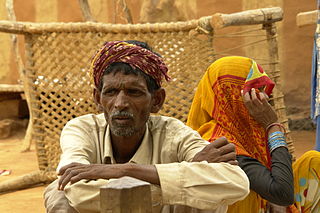
The Sahar, Sehariya, or Sahariya are an ethnic group in the state of Madhya Pradesh, India. The Saharias are mainly found in the districts of Morena, Sheopur, Bhind, Gwalior, Datia, Shivpuri, Vidisha and Guna districts of Madhya Pradesh and Baran district of Rajasthan.They are classified as Particularly vulnerable tribal group.

<span class="mw-page-title-main">Dholpur</span> City in Rajasthan, India

Dholpur is a city in the Dholpur district in Rajasthan state of India. It is situated on the left bank of the famous Chambal river. The city is the administrative headquarters of Dholpur District and was formerly seat of the Dholpur princely state.

Gird is a region of the Madhya Pradesh state in central India. It includes the districts of Bhind, Gwalior, Morena, Sheopur, and Shivpuri. Gwalior is the largest city in the region, and its historic center.

<span class="mw-page-title-main">Sawai Madhopur district</span> District of Rajasthan in India

Sawai Madhopur district is a district of Rajasthan state in north-west India. Sawai Madhopur is the chief town and district headquarters. Sawai Madhopur district comes under Bharatpur division.

<span class="mw-page-title-main">Bhind district</span> District of Madhya Pradesh in India

Bhind district is a district in the Chambal division of the Indian state of Madhya Pradesh. The town of Bhind is the district headquarters. Bhind District is situated in Chambal region in the northwest of the state. It is bounded by Agra, Etawah, Jalaun and Jhansi districts of Uttar Pradesh state to the north and the east, and the Madhya Pradesh districts of Datia to the south, Gwalior to the southwest, and Morena to the west. The geography of the district is characterised by uneven ravines, plain fertile fields and scanty forests. The total area of the district is 4,459 km2 (1,722 sq mi).

<span class="mw-page-title-main">Chambal division</span>

The Chambal Division is an administrative geographical unit of Madhya Pradesh state of India. A river by the name Chambal, a tributary of Yamuna River, forms the boundary between Rajasthan and Madhya Pradesh, in the upper part of the Chambal Division. Morena is the administrative headquarters of the division. As of 2012, the division consists of the three districts of Bhind district, Morena and Sheopur.

<span class="mw-page-title-main">Guna district</span> District of Madhya Pradesh in India

Guna district is one of the 52 districts of Madhya Pradesh in central India. Its administrative headquarters is Guna. The district has a population of 1,241,519. It has an area of 6390 km², and is bounded on the northeast by Shivpuri District, on the east by Ashoknagar District, on the southeast by Vidisha District, on the southwest by Rajgarh District, on the west and northwest by Jhalawar and Baran districts of Rajasthan state. The Sindh River flows northward along the eastern edge of the district, forming part of the boundary with Ashoknagar District, and the Parvati River flows northwestward through the southern portion of the district, forming part of the boundary with Baran District before flowing into Rajasthan.

<span class="mw-page-title-main">Lalitpur district, India</span> District of Uttar Pradesh in India

Lalitpur District is one of the districts of Uttar Pradesh state of India. Lalitpur district is a part of Jhansi Division. Lalitpur is the main town and administrative headquarters. The district occupies an area of 5,039 km².

<span class="mw-page-title-main">Shivpuri district</span> District of Madhya Pradesh in India

Shivpuri District is a district of Madhya Pradesh state of India. The town of Shivpuri is the district headquarters. National Highway 3 (NH-3) runs through the district.

<span class="mw-page-title-main">Morena district</span> District of Madhya Pradesh in India

Morena district is one of the 52 districts of the central Indian state of Madhya Pradesh, located in the Chambal division.

<span class="mw-page-title-main">Sheopur</span> City in Madhya Pradesh, India

Sheopur is a city in Madhya Pradesh state of central India. It is the administrative headquarters of Sheopur District. Sheopur is linked by narrow gauge rail to Gwalior(No longer in operation). The town is traditionally famous for its wood carving. Chambal River is just 25 km, which forms the boundary between Rajasthan and MP states.

<span class="mw-page-title-main">Banswara district</span> District of Rajasthan in India

Banswara District has an area of 5,037 km2 (1,945 sq mi), which is 1.47% of Rajasthan state, India. The city of Banswara is the district headquarters. It is bounded on the north by Udaipur District, on the northeast by Pratapgarh District, on the east and southeast by Madhya Pradesh state, on the southwest by Gujarat state, and on the west by Dungarpur District.

Vijaypur also known as Bijeypur is a Town located in district Sheopur, Madhya Pradesh, India. This town is a part of the Vijaypur constituency and Morena constituency. It is located on the bank of the Kwari River. The town is one of the gateways to the Kuno Wildlife Sanctuary, the site selected as a second home to the Asiatic Lion and also for cheetah reintroduction in India.

<span class="mw-page-title-main">Jaura, Madhya Pradesh</span> Jel mai in Madhya Pradesh, India

Jaura is a town and a nagar panchayat in Morena district in the Indian state of Madhya Pradesh.

Raghogarh-Ruthiyai or Raghogarh-Vijaypur is a town and municipality in Guna district in the Indian state of Madhya Pradesh.

Sabalgarh is a municipality in Morena district in the Indian state of Madhya Pradesh.

<span class="mw-page-title-main">Flora and fauna of Madhya Pradesh</span>

Madhya Pradesh, often called the Heart of India, is a state in central India. Its capital is Bhopal. Madhya Pradesh was originally the largest state in India until November 1, 2000 when the state of Chhattisgarh was carved out. It borders the states Uttar Pradesh, Chhattisgarh, Maharashtra, Gujarat and Rajasthan.

<span class="mw-page-title-main">Sheopur Assembly constituency</span> Constituency of the Madhya Pradesh legislative assembly

Sheopur Assembly constituency is one of the 230 Vidhan Sabha constituencies of Madhya Pradesh state in central India. This constituency came into existence in 1951, as Sheopur Pohri, one of the 79 Vidhan Sabha constituencies of the erstwhile Madhya Bharat state.

<span class="mw-page-title-main">Vijaypur, Madhya Pradesh Assembly constituency</span> Constituency of the Madhya Pradesh legislative assembly in India

Vijaypur Assembly constituency is one of the 230 Vidhan Sabha constituencies of Madhya Pradesh state in central India. This constituency came into existence in 1951, as Bijaypur, one of the 79 Vidhan Sabha constituencies of the erstwhile Madhya Bharat state.

<span class="mw-page-title-main">Pohari Assembly constituency</span> Constituency of the Madhya Pradesh legislative assembly in India

Pohari Assembly constituency is one of the 230 Vidhan Sabha constituencies of Madhya Pradesh state in central India. This constituency came into existence in 1951, as Sheopur Pohri, one of the 79 Vidhan Sabha constituencies of the erstwhile Madhya Bharat state.

References

  1. "Districts of India - Madhya Pradesh". india.gov.in website. Retrieved 4 February 2011.
  2. 1 2 3 4 5 6 7 "District Census 2011". Census2011.co.in. 2011. Retrieved 30 September 2011.
  3. "Tribal Districts , Government of Madhya Pradesh". Archived from the original on 7 August 2018. Retrieved 27 November 2011.
  4. Kabha, Asmita. "Displacement from wildlife protected areas and its impact on poverty and livelihood security: a study of Kuno wildlife sanctuary, Madhya Pradesh - Chapter 5" (PDF). shodhganga.inflibnet.ac.in.
  5. 1 2 Ministry of Panchayati Raj (8 September 2009). "A Note on the Backward Regions Grant Fund Programme" (PDF). National Institute of Rural Development. Archived from the original (PDF) on 5 April 2012. Retrieved 27 September 2011.
  6. "Delimitation of Parliamentary and Assembly Constituencies Order, 2008" (PDF). The Election Commission of India. pp. 226, 250.
  7. US Directorate of Intelligence. "Country Comparison:Population". Archived from the original on 13 June 2007. Retrieved 1 October 2011. Equatorial Guinea 668,225 July 2011 est.
  8. "2010 Resident Population Data". U. S. Census Bureau. Archived from the original on 19 October 2013. Retrieved 30 September 2011. North Dakota 672,591
  9. "C-16 Population By Religion - Madhya Pradesh". census.gov.in. Office of the Registrar General and Census Commissioner, India.
  10. 2011 Census of India, Population By Mother Tongue