Alirajpur district

Last updated

Alirajpur district
Aadiwasi tribal area traditional fair.jpg
Traditional Bhil fair in Alirajpur
MP Alirajpur district map.svg
Location of Alirajpur district in Madhya Pradesh
Coordinates(Alirajpur): 22°18′18″N74°21′36″E / 22.30500°N 74.36000°E / 22.30500; 74.36000
Country India
State Madhya Pradesh
Division Indore
Headquarters Alirajpur
Government
   District Magistrate Shri Raghvendra Singh
   Lok Sabha constituencies Ratlam
   Vidhan Sabha constituencies 1. Alirajpur, 2. Jobat
Area
  Total3,182 km2 (1,229 sq mi)
Population
 (2011)
  Total728,677
  Density230/km2 (590/sq mi)
Demographics
   Literacy 37.22 per cent
  Sex ratio1009
Time zone UTC+05:30 (IST)
Website alirajpur.nic.in

Alirajpur is one of the 52 districts of Madhya Pradesh state in India. It was created from Alirajpur, Jobat and Bhabra tehsils of the former Jhabua district on 17 May 2008. It is the least literate district in India as per Census 2011. Alirajpur is the administrative headquarters of the district. The district occupies an area of 2,165.24 square kilometres (836.00 sq mi), and at the 2011 census had a population of 728,999. It includes the city of Alirajpur.

Contents

Origin of name

The district is named after its headquarters, Alirajpur, which was the capital of the former princely state of Ali Rajpur. The name of this town is derived by conjoining Ali (the fortress town and the former capital of the princely state founded by Anand Deo in 1437) and Rajpur (the latter capital). [1] According to the 2011 census Alirajpur district has a population of 728,677, [2] roughly equal to the nation of Bhutan or the US state of Alaska. [3] [4] This gives it a ranking of 498th in India (out of a total of 640). [5] The district has a population density of 229 inhabitants per square kilometre (590/sq mi). [5] Its population growth rate over the decade 2001–2011 was 19.4 per cent. [5] Alirajpur has a sex ratio of 1,009 females for every 1,000 males, and a literacy rate of 37.22 per cent, the lowest in India. [3] [5]

Divisions

This district comprises Six tehsils and Development Blocks  : Alirajpur, Jobat, Sondwa, Udaigarh , Chandra Sekhra Ajad Nagar and Kathiwada. [6]

Presently, there are two Madhya Pradesh Vidhan Sabha constituencies in this district: Alirajpur and Jobat. [5] Both of these are part of Ratlam Lok Sabha constituency.

Demographics

Historical population
YearPop.±% p.a.
190170,763    
191198,753+3.39%
1921114,538+1.49%
1931133,892+1.57%
1941157,188+1.62%
1951175,255+1.09%
1961228,765+2.70%
1971293,125+2.51%
1981347,730+1.72%
1991483,481+3.35%
2001610,275+2.36%
2011728,999+1.79%
source: [7]
Religions in Alirajpur district (2011) [8]
ReligionPercent
Hinduism
96.72%
Islam
2.42%
Christianity
0.63%
Other or not stated
0.23%

According to the 2011 census Alirajpur district has a population of 728,999, [2] roughly equal to the nation of Bhutan or the US state of Alaska. [4] [9] This gives it a ranking of 498th in India (out of a total of 640). [2] The district has a population density of 229 inhabitants per square kilometre (590/sq mi). [2] Its population growth rate over the decade 2001–2011 was 19.45 per cent. [2] Alirajpur has a sex ratio of 1,009 females for every 1,000 males, and a literacy rate of 37.22 per cent, the lowest in India. [2] [3] Scheduled Castes and Scheduled Tribes make up 3.69% and 88.98% of the population respectively. [2]

Languages of Alirajpur district (2011)

   Bhilali (53.68%)
   Bhili (35.42%)
   Hindi (7.27%)
   Gujarati (1.87%)
  Others (1.76%)

Almost 90% of the population speaks different Bhili dialects. At the time of the 2011 Census of India, 53.68% of the population in the district spoke Bhilali, 35.42% Bhili, 7.27% Hindi and 1.87% Gujarati as their first language. [10]

See also

Related Research Articles

<span class="mw-page-title-main">Raisen district</span> District of Madhya Pradesh in India

Raisen District is a district of Madhya Pradesh state of India. The town of Raisen is the district headquarters. The district is part of Bhopal Division. Sanchi University of Buddhist-Indic Studies is the first international university located at Sanchi Town.

<span class="mw-page-title-main">Datia district</span> District of Madhya Pradesh in India

Datia District is in Gwalior Division in the Indian state of Madhya Pradesh. The town of Datia is its district headquarters.

<span class="mw-page-title-main">Dewas district</span> District of Madhya Pradesh in India

Dewas District is a district in the Indian state of Madhya Pradesh. The town of Dewas is the district headquarters.

<span class="mw-page-title-main">Dindori district</span> District of Madhya Pradesh in India

Dindori District, formerly known as Ramgarh District, is a district of Madhya Pradesh state of central India. The town of Dindori is the district headquarters. The district is part of Jabalpur Division. Total area of the district is 6,128 km2 (2,366 sq mi). It is located on the eastern part of Madhya Pradesh, bordering the state of Chhattisgarh. It is surrounded by Anuppur district to the northeast, Umaria district to the north, Jabalpur district to the west, Mandla district to the southwest and Mungeli and Kabirdham districts of Chhattisgarh to the south.

<span class="mw-page-title-main">Khargone district</span> District of Madhya Pradesh in India

Khargone district, formerly known as West Nimar district, is a district of Madhya Pradesh state in central India. The district lies in the Nimar region and is part of the Indore Division. The district headquarters is the city of Khargone, which lies south of the Indore metropolis, the headquarters of Indore district.

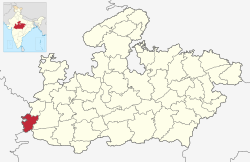
Alirajpur is a city in the Alirajpur tehsil in Alirajpur district in the state of Madhya Pradesh, India.

<span class="mw-page-title-main">Jhabua district</span> District of Madhya Pradesh in India

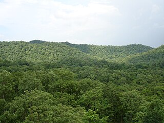
Jhabua is a district of Madhya Pradesh state in central India. The town of Jhabua is the administrative headquarters of the district.

<span class="mw-page-title-main">Barwani district</span> District of Madhya Pradesh in India

Barwani district is one of the districts of Madhya Pradesh state of India. The administrative headquarters of the district is at Barwani. Barwani district has an area of 5,427 km² and a population 1,385,881. The district lies in the southwestern corner of Madhya Pradesh; the Narmada River forms its northern boundary. The Satpura Range lies to its south. The district is bordered by Maharashtra state to the south, Gujarat state to the west, Dhar District to the north and Khargone District to the east.

<span class="mw-page-title-main">Burhanpur district</span> District of Madhya Pradesh in India

Burhanpur District is a district of Madhya Pradesh state in central India. The city of Burhanpur is the district headquarters.

<span class="mw-page-title-main">Dhar district, India</span> District of Madhya Pradesh in India

Dhar district is a district of Madhya Pradesh state in central India. The historic town of Dhar is administrative headquarters of the district.

<span class="mw-page-title-main">Ratlam district</span> District of Madhya Pradesh in India

Ratlam District is a district of Madhya Pradesh state in central India. The town of Ratlam is administrative headquarters of the district.

<span class="mw-page-title-main">Jhalawar district</span> District of Rajasthan in India

Jhalawar district is one of the 33 districts of Rajasthan state in western India. The historical city of Jhalawar is the administrative headquarters of the Jhalawar district. The district is bounded on the northwest by Kota district, on the northeast by Baran district, on the east by Guna district of Madhya Pradesh state, on the south by Rajgarh district and Agar Malwa district of Madhya Pradesh state and on the west by Ratlam district and Mandsaur district of Madhya Pradesh state. The district occupies an area of 6219 km². The district is part of Kota division. To know more about Jhalawar City

<span class="mw-page-title-main">Indore district</span> District of Madhya Pradesh, India

The Indore District is a district of Madhya Pradesh state in central India. It is believed that the city is named after its Indreshwar Mahadev Temple, Where Indra is the presiding deity. The Gupta inscriptions name Indore as "Indrapura". It is also called the administrative capital. This district forms part of the Indore Division.

<span class="mw-page-title-main">Vidisha district</span> District of Madhya Pradesh in India

Vidisha District (विदिशा) is in Madhya Pradesh state, in central India. The city of Vidisha is the administrative headquarters of the district.

<span class="mw-page-title-main">Khandwa district</span> District of Madhya Pradesh in India

Khandwa district, formerly known as the East Nimar district, is a district of the Madhya Pradesh state in central India. The city of Khandwa is the administrative headquarters of the district. Other notable towns in the district include Mundi, Harsud, Pandhana and Omkareshwar.

<span class="mw-page-title-main">Bhopal district</span> District of Madhya Pradesh in India

Bhopal District is a district of Madhya Pradesh state in central India. The city of Bhopal serves as its administrative headquarters. The district is part of Bhopal Division.

<span class="mw-page-title-main">Banswara district</span> District of Rajasthan in India

Banswara District has an area of 5,037 km2 (1,945 sq mi), which is 1.47% of Rajasthan state, India. The city of Banswara is the district headquarters. It is bounded on the north by Udaipur District, on the northeast by Pratapgarh District, on the east and southeast by Madhya Pradesh state, on the southwest by Gujarat state, and on the west by Dungarpur District.

<span class="mw-page-title-main">Kabirdham district</span> District of Chhattisgarh in India

Kabirdham district is one of the 33 administrative districts of Chhattisgarh state in central India. The district was earlier known as Kawardha district. The district is located between 21.32' to 22.28' north latitude and 80.48' to 81.48' east longitude. The district covers an area of 4,447.5 km2 (1,717.2 sq mi). The city of Kawardha is its administrative headquarters. This district is known for the Bhoramdeo temple located at a distance of 18 km from the district headquarters, Kawardha.

Alirajpur Tehsil is a fourth-order administrative and revenue division, a subdivision of third-order administrative and revenue division of Alirajpur district of Madhya Pradesh.

Bhavra tehsil is a fourth-order administrative and revenue division, a subdivision of third-order administrative and revenue division of Alirajpur district of Madhya Pradesh.

References

  1. "Ali Rajpur". Imperial Gazetteer of India, vol. 5, p. 223.
  2. 1 2 3 4 5 6 7 "District Census Handbook: Alirajpur" (PDF). Census of India . Registrar General and Census Commissioner of India. 2011.
  3. 1 2 3 Dhar, Aarti (31 March 2011). "Significant boost in literacy: 2011 census". The Hindu . New Delhi. Retrieved 1 April 2011.
  4. 1 2 US Directorate of Intelligence. "Country Comparison:Population". Archived from the original on 13 June 2007. Retrieved 1 October 2011. Bhutan 708,427
  5. 1 2 3 4 5 "District/Assembly List". Chief Electoral Officer, Madhya Pradesh website. Archived from the original on 1 December 2015. Retrieved 16 April 2010.
  6. "Government of Madhya Pradesh website for Alirajpur District".
  7. "Table A-02 Decadal Variation in Population Since 1901: Madhya Pradesh" (PDF). census.gov.in. Registrar General and Census Commissioner of India.
  8. "Table C-01 Population By Religion: Madhya Pradesh". census.gov.in. Registrar General and Census Commissioner of India.
  9. "2010 Resident Population Data". US Census Bureau. Archived from the original on 19 October 2013. Retrieved 30 September 2011. Alaska 710,231
  10. "Table C-16 Population by Mother Tongue: Madhya Pradesh". censusindia.gov.in. Registrar General and Census Commissioner of India.