Ratlam district

Last updated

Ratlam district
Sailana Palace.jpg
Sailana Palace
MP Ratlam district map.svg
Location of Ratlam district in Madhya Pradesh
Coordinates(Ratlam): 23°20′N75°03′E / 23.33°N 75.05°E / 23.33; 75.05
CountryFlag of India.svg  India
State Madhya Pradesh
Division Ujjain
Established26-1-1949
Headquarters Ratlam
Tehsils 9
Government
   Lok Sabha constituencies Ratlam
Area
  Total4,861 km2 (1,877 sq mi)
Population
 (2011)
  Total1,455,069
  Density300/km2 (780/sq mi)
Demographics
   Literacy 68.03 per cent
  Sex ratio973
Time zone UTC+05:30 (IST)
Major highways NH 79, NH 927A
Website ratlam.nic.in

Ratlam District is a district of Madhya Pradesh state in central India. The town of Ratlam is administrative headquarters of the district.

Contents

Geography

Ratlam District has an area of 4,861 square kilometres (1,877 sq mi). It is bounded by Mandsaur District to the north, Jhalawar District of Rajasthan state to the northwest, Ujjain District to the east, Dhar District to the south, Jhabua District to the southwest, and Pratapgarh District of Rajasthan to the west. It is divided into nine tehsils and is home to 9 at and 1,063 villages (as of 2001). The district is part of Ujjain Division. [1]

Tehsils

  1. Ratlam
  2. Bajna
  3. Jaora
  4. Sailana
  5. Raoti
  6. Piploda
  7. Tal
  8. Aalot
  9. Namli [2]

Information

Ratlam (yellow) and Sailana (green) States held major parts of present day Ratlam district. Map of Sailana and Ratlam States.jpg
Ratlam (yellow) and Sailana (green) States held major parts of present day Ratlam district.

Ratlam District was created after Indian independence in 1947, primarily out of the territories of the princely states of Ratlam State and Sailana State, the rulers of Ratlam and Sailana were descendants of Maharaja Ratan Singh Rathore. Other states included Jaora State which was created by the British in 1818 and Piploda State which was a tributary of Jaora but later became a small non-gunsalute state. Ratlam District was part of the new state of Madhya Bharat. The major stop for tourism in Ratlam district is the town of Sailana which is known for its cactus garden, Palace, Kharmor Bird Sanctuary and the cave temples of Kedareshwar. Ratlam city is known for Garadu (fried Yam), Sev and Gold. Ratlam also has a DRM office of Railway. [1]

Demographics

Historical population
YearPop.±% p.a.
1901238,624    
1911244,513+0.24%
1921245,021+0.02%
1931290,437+1.71%
1941335,147+1.44%
1951381,719+1.31%
1961483,521+2.39%
1971626,534+2.62%
1981782,729+2.25%
1991971,888+2.19%
20011,215,393+2.26%
20111,455,069+1.82%
source: [3]
Religions in Ratlam district (2011) [4]
ReligionPercent
Hinduism
87.08%
Islam
10.38%
Jainism
2.01%
Other or not stated
0.53%

According to the 2011 census Ratlam District has a population of 1,455,069 [5] roughly equal to the nation of Eswatini [6] or the US state of Hawaii. [7] This gives it a ranking of 342nd in India (out of a total of 640). [5] The district has a population density of 299 inhabitants per square kilometre (770/sq mi) . [5] Its population growth rate over the decade of 2001-2011 was 19.67%. [5] Ratlam has a sex ratio of 973 females for every 1,000 males, [5] and a literacy rate of 68.03%. 29.90% of the population lives in urban areas. Scheduled Castes and Tribes made up 13.65% and 28.16% of the population respectively. [5]

Languages of Ratlam district (2011) [8]

   Malvi (42.32%)
   Hindi (41.38%)
   Bhili (13.59%)
   Urdu (1.27%)
  Others (1.44%)

At the time of the 2011 Census of India, 42.33% of the population in the district spoke Malvi, 41.38% Hindi, 13.59% Bhili and 1.27% Urdu as their first language. [8]

Tourist places

Related Research Articles

<span class="mw-page-title-main">Ratlam</span> City in Madhya Pradesh, India

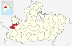
Ratlam is a city in the northwestern part of the Malwa region in Madhya Pradesh state of India. The city of Ratlam lies 480 metres (1,570 ft)above sea level. It is the administrative headquarters of Ratlam district, which was created in 1947 after the independence of India. It is located 294 kilometres west of the state capital Bhopal.

<span class="mw-page-title-main">Jaora</span> City in Madhya Pradesh, India

Jaora is a city and a municipality in Ratlam district in the Indian state of Madhya Pradesh. Jaora is located in the Malwa region, between Ratlam and Mandsaur. It was the capital of the Jaora princely state of Jaora before Independence. During the Mourning of Muharram, thousands of people from all over the world visit the shrine of Hussain Tekri. Jains visit Jaora as a place that the Jain ascetic Rajendrasuri practiced tapasya.

<span class="mw-page-title-main">Sheopur district</span> District of Madhya Pradesh in India

Sheopur District is a district of Madhya Pradesh state in central India. The district is located in the north of the state and forms part of Chambal division. It is situated on the periphery of Rajasthan, which shows in the influence of Rajasthani culture in this district.

<span class="mw-page-title-main">Bhind district</span> District of Madhya Pradesh in India

Bhind district is a district in the Chambal division of the Indian state of Madhya Pradesh. The town of Bhind is the district headquarters.Bhind District is situated in Chambal region in the northwest of the state.

<span class="mw-page-title-main">Dewas district</span> District of Madhya Pradesh in India

Dewas District is a district in the Indian state of Madhya Pradesh. The town of Dewas is the district headquarters.

<span class="mw-page-title-main">Chhatarpur district</span> District in Madhya Pradesh, India

Chhatarpur District is a district of Madhya Pradesh state of central India. The town of Chhatarpur is the district headquarters.

<span class="mw-page-title-main">Sailana</span> City in Madhya Pradesh, India

Sailana is a town in the Malwa region of the Indian state of Madhya Pradesh. Sailana is 25 km (16 mi) from Ratlam city and 50 km (31 mi) away from Banswara district of the neighboring state of Rajasthan.

Sailana was once the capital of the Sailana State before it merged into India. A fort belonging to the former royal family still stands tall in Sailana. The Kedareshwar temple, situated 4 km (2.5 mi) from Sailana is a notable shrine.

<span class="mw-page-title-main">Guna district</span> District in Madhya Pradesh, India

Guna district is one of the 52 districts of Madhya Pradesh in central India. Its administrative headquarters is Guna. The district has a population of 1,241,519. It has an area of 6390 km², and is bounded on the northeast by Shivpuri District, on the east by Ashoknagar District, on the southeast by Vidisha District, on the southwest by Rajgarh District, on the west and northwest by Jhalawar and Baran districts of Rajasthan state. The Sindh River flows northward along the eastern edge of the district, forming part of the boundary with Ashoknagar District, and the Parvati River flows northwestward through the southern portion of the district, forming part of the boundary with Baran District before flowing into Rajasthan.

<span class="mw-page-title-main">Jhabua district</span> District of Madhya Pradesh in India

Jhabua is a district of Madhya Pradesh state in central India. The town of Jhabua is the administrative headquarters of the district.

<span class="mw-page-title-main">Dhar district, India</span> District of Madhya Pradesh in India

Dhar district is a district of Madhya Pradesh state in central India. The historic town of Dhar is administrative headquarters of the district.

<span class="mw-page-title-main">Mandsaur district</span> District of Madhya Pradesh in India

Mandsaur district is a District of Madhya Pradesh state in central India. The town of Mandsaur is the administrative headquarters of the district.The ancient Pashupatinath temple is situated in Mandsaur. Large quantities of opium are produced in Mandsaur district.

<span class="mw-page-title-main">Jhalawar district</span> District of Rajasthan in India

Jhalawar district is one of the 33 districts of Rajasthan state in western India. The historical city of Jhalawar is the administrative headquarters of the Jhalawar district. The district is bounded on the northwest by Kota district, on the northeast by Baran district, on the east by Guna district of Madhya Pradesh state, on the south by Rajgarh district and Agar Malwa district of Madhya Pradesh state and on the west by Ratlam district and Mandsaur district of Madhya Pradesh state. The district occupies an area of 6219 km². The district is part of Kota division. To know more about Jhalawar City

<span class="mw-page-title-main">Neemuch district</span> District of Madhya Pradesh in India

Neemuch district is one of the 53 districts of Madhya Pradesh state in central India. The town of Neemuch is the administrative headquarters of the district.

<span class="mw-page-title-main">Ujjain district</span> District of Madhya Pradesh in India

Ujjain district is a district of Madhya Pradesh state in central India. The historic city of Ujjain is the district headquarters. The district has an area of 6,091 km2, and a population of 19,86,864, a 16.12% increase from its 2001 population of 17,10,982.

<span class="mw-page-title-main">Indore district</span> District of Madhya Pradesh, India

The Indore District is a district of Madhya Pradesh state in central India. It is believed that the city is named after its Indreshwar Mahadev Temple, Where Indra is the presiding deity. The Gupta inscriptions name Indore as "Indrapura". It is also called the administrative capital. This district forms part of the Indore Division.

<span class="mw-page-title-main">Vidisha district</span> District of Madhya Pradesh in India

Vidisha District (विदिशा) is in Madhya Pradesh state, in central India. The city of Vidisha is the administrative headquarters of the district.

<span class="mw-page-title-main">Sehore district</span> District of Madhya Pradesh in India

Sehore District is a district of Madhya Pradesh state in central India. The town of Sehore is the district headquarters. The district is part of Bhopal Division.

Piploda is a town and a Nagar Parishad in Ratlam district in the Indian state of Madhya Pradesh.

<span class="mw-page-title-main">Alirajpur district</span> District of Madhya Pradesh in India

Alirajpur is one of the 52 districts of Madhya Pradesh state in India. It was created from Alirajpur, Jobat and Bhabra tehsils of the former Jhabua district on 17 May 2008. It is the least literate district in India as per Census 2011. Alirajpur is the administrative headquarters of the district. The district occupies an area of 2,165.24 square kilometres (836.00 sq mi), and at the 2011 census had a population of 728,999. It includes the city of Alirajpur.

Sarvan is a village in Sailana Tehsil in Ratlam district of Madhya Pradesh, India. It belongs to Ujjain division. It is located 32 km north of District headquarters Ratlam and 298 km from State capital Bhopal. Sarvan Pin code is 457550 and postal head office is Sailana.

References

  1. 1 2 "Ratlam". Ratlam district administration. Retrieved 12 August 2010.
  2. https://ratlam.nic.in/en/tehsil/
  3. "Table A-02 Decadal Variation in Population Since 1901: Madhya Pradesh" (PDF). census.gov.in. Registrar General and Census Commissioner of India.
  4. "Table C-01 Population By Religion: Madhya Pradesh". census.gov.in. Registrar General and Census Commissioner of India.
  5. 1 2 3 4 5 6 "District Census Handbook: Ratlam" (PDF). Census of India . Registrar General and Census Commissioner of India. 2011.
  6. US Directorate of Intelligence. "Country Comparison:Population". Archived from the original on 13 June 2007. Retrieved 1 October 2011. Swaziland 1,370,424
  7. "2010 Resident Population Data". U. S. Census Bureau. Retrieved 30 September 2011. Hawaii 1,360,301
  8. 1 2 "Table C-16 Population by Mother Tongue: Madhya Pradesh". censusindia.gov.in. Registrar General and Census Commissioner of India.