Garoth

Last updated

Garoth
Madhya Pradesh location map.svg
Red pog.svg
Garoth
Location in Madhya Pradesh, India
Coordinates: 24°19′29″N75°39′7″E / 24.32472°N 75.65194°E / 24.32472; 75.65194
CountryFlag of India.svg  India
State Madhya Pradesh
District Mandsaur
Area
  Total120 km2 (50 sq mi)
Population
 (2012)
  Total15,122
  Density130/km2 (330/sq mi)
Languages
  Official Hindi
Time zone UTC+5:30 (IST)
PIN
458880
Telephone code07425
Vehicle registration M.P-14
Sex ratio 51% Male 49% Female /
Literacy87.38% [1] %

Garoth is a town in Madhya Pradesh state in central India. It is one of the tehsil of Mandsaur District.It shares boundary with Jhalawar district of Rajasthan.The local Language or dialect spoken here is a mixture of Mewari, Harauti and Malwi Languages.Latitude and longitude coordinates are: 24.328077, 75.649902.

Contents

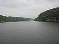
Garoth is a small town situated near Gandhi Sagar Lake, in northern Madhya Pradesh, India. The town is famous with its beautiful setting, great views, and very friendly opened people. The town is an agricultural spot, as well as a small educational center, where a high school and a college can be found.

Demographics

The town has an area of 9,791 km2. The district is bounded by Neemuch District to the north, Rajasthan state to the east and west and It is part of Ujjain Division

Garoth forms the northern projection of Madhya Pradesh from its western Division, i.e., Ujjain Commissioner's Division

[ needs update ] As of the 2011 Census of India, [2] Garoth had a population of 1,89,729. Males constitute 51% of the population and females 49%. Garoth has an average literacy rate of 63%, higher than the national average of 59.5%: male literacy is 76%, and female literacy is 50%. In Garoth, 15% of the population is under 6 years of age.

Gandhi Sagar dam

Gandhisagar Dam is situated at a distance of 42  km. from the city headquarter. The Dam is constructed on the Chambal River.

Related Research Articles

<span class="mw-page-title-main">Ratlam</span> City in Madhya Pradesh, India

Ratlam is a city in the northwestern part of the Malwa region in Madhya Pradesh state of India. The city of Ratlam lies 480 metres (1,570 ft)above sea level. It is the administrative headquarters of Ratlam district, which was created in 1947 after the independence of India. It is located 294 kilometres west of the state capital Bhopal.

<span class="mw-page-title-main">Rajgarh, Madhya Pradesh</span> City in Madhya Pradesh, India

Rajgarh is a city and a municipality in the state of Madhya Pradesh in India. It is the administrative headquarters of Rajgarh District, and was a princely state under the British Raj, named Rajgarh State. The old city belongs to the Malwa region and is surrounded by a battlemented wall. Rajgarh is now known for NTPC solar power plant and dam projects running over here, as a result companies like Tata and Reliance power have shown interest.Rajgarh is also famous for Jalpama temple

Kanad is a town and a nagar parishad in Agar Malwa district in the Indian state of Madhya Pradesh. It comes under Kanad Parishad. It belongs to Ujjain Division. It is situated along the Agar–Sarangpur SH-41 highway. It is located 18 km (11 mi) towards east from the district headquarters of Agar Malwa, 83 km (52 mi) from Ujjain, 186 km (116 mi) from the state capital of Bhopal.

<span class="mw-page-title-main">Mandsaur district</span> District of Madhya Pradesh in India

Mandsaur district is a District of Madhya Pradesh state in central India. The town of Mandsaur is the administrative headquarters of the district.The ancient Pashupatinath temple is situated in Mandsaur. Large quantities of opium are produced in Mandsaur district.

<span class="mw-page-title-main">Ratlam district</span> District of Madhya Pradesh in India

Ratlam District is a district of Madhya Pradesh state in central India. The town of Ratlam is administrative headquarters of the district.

<span class="mw-page-title-main">Rajgarh district</span> District of Madhya Pradesh in India

Rajgarh district is a district of Madhya Pradesh in central India. The city of Rajgarh is the administrative headquarters of the district. The old name of Rajgarh was Jhanjhanipur. Rajgarh in Madhya Pradesh is one of the aspirational districts selected by Government of India. The district has an area of 6,154 km² and the population is 1,545,814. The district lies on the northern edge of the Malwa plateau, and the Parbati River forms the eastern boundary of the district, while the Kali Sindh River forms the western boundary. The district has seven tehsils, Rajgarh, Khilchipur, Jirapur, Biaora, Narsinghgarh, Sarangpur and Pachore. The district is bounded by Rajasthan state to the north, and by the districts of Guna to the northeast, Bhopal to the east, Sehore to the southeast, and Shajapur to the south and west. It is part of Bhopal Division. There are 1728 villages in Rajgarh.

<span class="mw-page-title-main">Neemuch district</span> District of Madhya Pradesh in India

Neemuch district is one of the 55 districts of Madhya Pradesh state in central India. The town of Neemuch is the administrative headquarters of the district.

<span class="mw-page-title-main">Ujjain district</span> District of Madhya Pradesh in India

Ujjain district is a district of Madhya Pradesh state in central India. The historic city of Ujjain is the district headquarters. The district has an area of 6,091 km2, and a population of 19,86,864, a 16.12% increase from its 2001 population of 17,10,982.

Mahidpur City is a city and a municipality, near Ujjain city in Ujjain district in the Indian state of Madhya Pradesh. Mahidpur City takes its name from Raja Jhala Maheda Singh, who was the founder of Mahidpur. The modern town of Mahidpur is situated on the bank of river Shipra. It is located in the Malwa region. At present, the town is a tehsil place of Ujjain district.

<span class="mw-page-title-main">Sehore district</span> District of Madhya Pradesh in India

Sehore District is a district of Madhya Pradesh state in central India. The town of Sehore is the district headquarters. The district is part of Bhopal Division.

Gogapur is a census town in tehsil Mehidpur City and Ujjain district in the Indian state of Madhya Pradesh.This town is commonly known as Mehidpur Road and Mehidpur Mandi.

Jirapur is a town and a nagar panchayat in Rajgarh district in the Indian state of Madhya Pradesh. In 2022 Janpad Panchayat election held across Madhya Pradesh, Congress won the election and secure position as a Janpad Adhyaksh under the leadership of Khilchipur vidhayak Shri Priyavrat Singh Ji. He put all the efforts to win this election and doing great work for Khilchipur constituency. He won 2018 assembly election of Madhya Pradesh with huge margin of 30,000+ votes by defeating Kunwar Hajarilal Dangi of Bharatiya Janata Party (BJP) candidate.

Kantaphod is a small village and a nagar panchayat in Dewas district in the Indian state of Madhya Pradesh. It is located on the foot of Malwa plateau on the bank of Chandrakeshar river.

Machalpur is a town and a nagar parishad in Rajgarh district in the Indian state of Madhya Pradesh.

Nalkheda is a town (Tehsil) and a nagar Parishad in Agar Malwa district in the Indian state of Madhya Pradesh. Nalkheda is situated on the bank of river Lakhunder.

Pipri is a town and a nagar panchayat in Sonbhadra district in the Indian state of Uttar Pradesh.

Shujalpur is a city and a municipality in Shajapur district in the Indian state of Madhya Pradesh. Ranoji Rao Shinde, father of Mahadji Shinde (Scindia), died in 1745 at Shujalpur, where his cenotaph (chattri) stands which houses a Shiv temple. It is known as Ranoganj.

Soyat Kalan or Soyat is a town and a Nagar Parishad in Agar Malwa district in the Indian state of Madhya Pradesh.

Tarana is a town and a nagar parishad in Ujjain district in the Indian state of Madhya Pradesh. Tarana is a tehsil in Ujjain and the distance to Ujjain is 34 km. Tarana was part of Holkar estate. The current M.L.A of Tarana constituency is Mahesh Parmar (INC).

Narayangarh is a nagar panchayat city in district of Mandsaur, Madhya Pradesh. The city is divided into 15 wards for which elections are held every 5 years. The Narayangarh Nagar Panchayat has population of 10,191 of which 5,168 are males while 5,023 are females as per report released by Census India 2011.

References

  1. "Literacy rate". 16 June 2004. Retrieved 29 April 2012.
  2. "Census of India 2001: Data from the 2001 Census, including cities, villages and towns (Provisional)". Census Commission of India. Archived from the original on 16 June 2004. Retrieved 1 November 2008.