
Deoband is a town and a municipality in Saharanpur district in the state of Uttar Pradesh, India. Deoband is located about 150 km from Delhi. The world famous Islamic seminary, Darul Uloom Deoband is situated here.
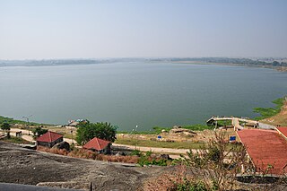
Kanke is a census town in the Kanke CD block in the Ranchi Sadar subdivision of Ranchi district in the Indian state of Jharkhand. Kanke has a large water reservoir called Kanke Dam, which is used to supply water to Ranchi city.

Ratlampronunciation (help·info), known historically as Ratnapuri, is a city in the northwestern part of the Malwa region in Madhya Pradesh state of India. The city of Ratlam lies 480 metres above sea level. It is the administrative headquarters of Ratlam district, which was created in 1947 after the independence of India.

Lohardaga is a town and the district headquarters of Lohardaga district in the Indian state of Jharkhand, west of Ranchi, the state capital. Earlier Lohardaga was the commissionary headquarters for Chotanagpur. It was only later that the commissionary of Chotanagpur was shifted to Ranchi. The commissioner's office still exists and it houses the Lohardaga Municipality office.
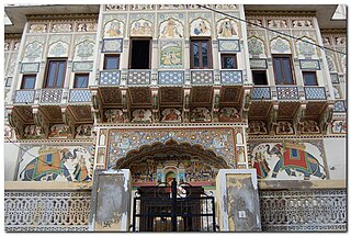
Mandawa is a town in Jhunjhunu district of Rajasthan in India. It is part of Shekhawati region. Mandawa is located at 28.05°N 75.15°E. It has an average elevation of 316 metres (1036 ft).
Piploda is a town and a Nagar Parishad in Ratlam district in the Indian state of Madhya Pradesh.
Tal is a town and a nagar parishad in Ratlam District of the Indian state of Madhya Pradesh. Raja Tariya Bhil established Tal in 1243 AD.

Partapur is a municipality in Banswara district in the Indian state of Rajasthan. It is a fast growing area in the Wagad region and the second largest populated city in the Banswara district.
Badawada is a Nagar Panchayat city in district of Ratlam, Madhya Pradesh. Badawada is divided into 15 wards for which elections are held every 5 years.
Gogapur is a census town in tehsil Mehidpur City and Ujjain district in the Indian state of Madhya Pradesh.This town is commonly known as Mehidpur Road and Mehidpur Mandi.

Kadipur is a town, tehsil and a nagar panchayat in Sultanpur district in the Indian state of Uttar Pradesh. It is located a short distance from the bank of the Gomti River, at a crossroads between two roads heading from Sultanpur to Surapur and from Pratapgarh to Dostpur and then on to Akbarpur. On the north side of town is a stream with a steep ravine that drains the surrounding area. The road to Sultanpur crosses over this stream on a bridge. The lands surrounding Kadipur are average quality for agricultural purposes. As of 2011, Kadipur has a population of 8,010 people, in 1,216 households.
Malhargarh is a town and a tehsil in Mandsaur district in the Indian state of Madhya Pradesh. It is located between Neemuch and Mandsaur on the Ratlam- Chittaurgarh Section of Indian railway. Malhargarh is rich in agriculture and part of the Malwa region.

Monoharpur is a village in Chanditala II CD Block in Srirampore subdivision of Hooghly district in the state of West Bengal, IndiaIt was earlier recorded as a census town.
Ratlam Railway Colony, also known as Ratlam Kasba, is a census town in Ratlam District in the Indian state of Madhya Pradesh.It stretches from Dat ki Pul to the Railway hospital. The colony ends at Gandhinagar and the railway station on the opposite side. It is home to two railway schools, a full-sized basketball court, a full-size track and field ground and a volleyball court. The colony boasts two clubs with badminton courts and pool table.
Salumbar is a statutory town in Udaipur district in the Indian state of Rajasthan.
Sarwar is a city and a sub division in Ajmer district in the Indian state of Rajasthan. Sarwar is a nagar palika and panchayat samiti also. It is part of kekri vidhansabha constituency and ajmer loksabha constituency.

Shahkot is a small city and a tehsil among 5 tehsils of Jalandhar district, Punjab, India. Shahkot is situated on Jalandhar-Moga-Barnala-Sirsa National Highway 703. Shahkot is administered by the Municipal Committee. About 250 villages belong to Shahkot tehsil. Shahkot was famous for its red chili peppers; but now, its main crops are Wheat, Paddy, Maize, potato, etc Agriculture Land is not suitable for Paddy. But with the use of pesticides and tubewell water; paddy is grown.
Udpura is a census town in Kota District in the Indian state of Rajasthan.
Manpur is a town and a nagar panchayat in Mhow Tehsil of Indore district in the Indian state of Madhya Pradesh.

Shirahatti is a panchayat town in Gadag district in the Indian state of Karnataka.

