
Hoshangabad, officially Narmadapuram, is a city in the Indian state of Madhya Pradesh. It serves as the headquarters of both Hoshangabad district and Narmadapuram division. It is located in central India, on the south bank of the Narmada River. Hoshangabad is 76.7 km (47.7 mi) from the capital of Madhya Pradesh and the nearest airport Bhopal.
Harda is a city and a municipality in Harda district in the Indian state of Madhya Pradesh. Harda is the administrative headquarters of Harda.

Datia, also known as Daityavakra is the district headquarter of the Datia District in north central Madhya Pradesh, a state of Central India. It is an ancient town, mentioned in the Mahabharata ruled by King Dantavakra. The city is 78 km from Gwalior, 325 km south of New Delhi and 344 km north of Bhopal. About 18 km from Datia is Sonagiri, a sacred Jain hill. Datia is also about 28 km from Jhansi and 52 km from Orchha. The nearest airport is at Gwalior. It was formerly the seat of the eponymous princely state in the British Raj. Datia is situated near Gwalior and on the border with Uttar Pradesh.

Ratlam is a city in the northwestern part of the Malwa region in Madhya Pradesh state of India. The city of Ratlam lies 480 metres (1,570 ft)above sea level. It is the administrative headquarters of Ratlam district, which was created in 1947 after the independence of India. It is located 294 kilometres west of the state capital Bhopal.
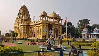
Rajgarh is a city and a municipality in the state of Madhya Pradesh in India. It is the administrative headquarters of Rajgarh District, and was a princely state under the British Raj, named Rajgarh State. The old city belongs to the Malwa region and is surrounded by a battlemented wall. Rajgarh is now known for NTPC solar power plant and dam projects running over here, as a result companies like Tata and Reliance power have shown interest.Rajgarh is also famous for Jalpama temple
Rajnandgaon is a city in Rajnandgaon District, in the state of Chhattisgarh, India. As of the 2011 census the population of the city was 163,122. Rajnandgaon district came into existence on 26 January 1973, as a result of the division of Durg district.
Betul is Municipal Council town in Madhya Pradesh, India. It is the administrative head-quarter of Betul district and forms the southernmost part of the Narmadapuram Division.
Kavali is a town in Nellore district of Andhra Pradesh of India. It also serves as headquarters of Kavali mandal and Kavali revenue division.It is one of the few cities from Andhra Pradesh which were selected for Atal Mission for Rejuvenation and Urban Transformation (AMRUT) Scheme.
Sehore is a city and a municipality in Sehore district in the Indian state of Madhya Pradesh. It is the district headquarters of Sehore District and is located on the Bhopal-Sehore-Indore highway, 38 km from Bhopal.
Buldhana is a City and a Municipal Council in the Indian state of Maharashtra. Established on 17 February 1893. It is the Administrative headquarters of the Buldhana District of Amravati division. It is the Second largest City in the district after Khamgaon and a popular place as a hill station because the city is surrounded by the mountainous area in the Ajanta range. Buldhana is around 552 km away from the state capital Mumbai. Buldhana has many religious, historical and tourist places around it like Balaji Temple in rajur ghat a replica of popular Balaji Temple of South India, is a famous religious and tourist place within city limits, Shri Gajanan Maharaj Temple in Shegaon around 75 km away, the World Famous Lonar Crater a National Geo-heritage monument created by meteorite impact is almost 100 km from city of Buldhana, Rajmata Jijau birthplace Sindkhed Raja is 90 km, Sailani Baba Dargah a major attraction of Buldhana just 25 km away from the city, The World Heritage Site Ajanta Caves is just 55 km away from the City and Dnyanganga Wildlife Sanctuary in Botha Forest is also just 20 km away from the city and many more tourist places are there around Buldhana City.
Batote is a town and a notified area committee, near Ramban town in Ramban district of Indian union territory of Jammu and Kashmir on NH 44 just beyond Ramban, Patnitop while going towards Srinagar.
Gaurela, also known as Pendra road, is a Census town part of Gaurela-Pendra-Marwahi district in the state of Chhattisgarh, India. Gaurela and Pendra are twin cities.
Kantaphod is a small village and a nagar panchayat in Dewas district in the Indian state of Madhya Pradesh. It is located on the foot of Malwa plateau on the bank of Chandrakeshar river.
Karnawad is a town and a nagar panchayat in Dewas district in the Indian state of Madhya Pradesh.
Mhowgaon is a Nagar Panchayat under Sub Division Dr. Ambedkar Nagar (Mhow) in Indore district in the Indian state of Madhya Pradesh. The total geographical area of Mhowgaon nagar panchayat is 13.5 km2 and it is the smallest city by area in the sub district. The population density of the city is 2309 persons per km2. Mhowgaon is divided into 15 wards for which elections are held every 5 years. Among them, Mhowgaon Ward No. 2 is the most populous ward with a population of 3440 and Mhowgaon Ward No. 15 is the least populous ward with a population of 957. Mhowgaon Nagar Panchayat has total administration over 6,373 houses to which it supplies basic amenities like water and sewerage. It is also authorized to build roads within Nagar Panchayat limits and impose taxes on properties coming under its jurisdiction.
Satwas is a town and a Nagar Panchayat in Dewas district in the Indian state of Madhya Pradesh. Satwas is around 136.8 km (85.0 mi) from Dewas.
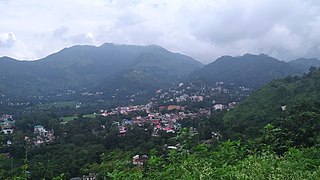
Sundar Nagar is a town and a municipal council in Mandi district in the Indian state of Himachal Pradesh. It was formerly a princely state, known as Suket.
Talen is a town in Madhya Pradesh, India.
Banapura is a small town in the Hoshangabad District of Madhya Pradesh, India. Banapura is a twin city of Seoni Malwa.

Khajuraho is a city, near Chhatarpur in Chhatarpur district of the Indian state of Madhya Pradesh. One of the most popular tourist destinations in India, Khajuraho has the country's largest group of medieval Hindu and Jain temples, famous for their erotic sculptures. The Khajuraho Group of Monuments has been listed as a UNESCO World Heritage Site since 1986 and is considered one of the "seven wonders" of India. The town's name, anciently "Kharjuravahaka", is derived from the Sanskrit word kharjur meaning "date palm".
