Kurwai is a town and a Nagar Panchayat in Vidisha district in the Indian state of Madhya Pradesh. its also tehsil headquarter and assembly constituency.

Bhind is a city in the Indian state of Madhya Pradesh. It is the headquarters of the Bhind district.

Sidhi is a town and a municipality in Sidhi district in the Indian state of Madhya Pradesh. It is the headquarters of the Sidhi district.
Pithampur is a town near Dhar city in the Dhar district of Madhya Pradesh, India. Pithampur is an industrial city, and is a part of Indore Metropolitan Region. Pithampur houses major industries and companies of Madhya Pradesh.
Sardarpur is a town and a nagar panchayat in Dhar district in the Indian state of Madhya Pradesh. It is a town on Mahi river on the Malwa plateau. There is an ancient Shivalinga situated at the bank of Mahi river at a place called Shree Jhineshwar Dham; Shri Mohankheda Jain Thirth and Bhopawar Jain Tirth are located nearby.
Bhander is a town and a nagar panchayat in Datia district in the state of Madhya Pradesh.
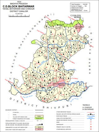
Bhitarwar is a city and a municipality in Gwalior district in the state of Madhya Pradesh, India. The town is surrounded by a river called Parbati.
Chandla is a town and a nagar parishad,Chandla Assembly constituency in Chhatarpur district in the state of Madhya Pradesh, India.
Gurh is a town and a nagar panchayat in Rewa district in the Indian state of Madhya Pradesh. It is 23 kilometres from Rewa city. It is also famous for the Bhairav Baba statue.Its nearest towns are Manikwar 18 km Mangawan 25 km and Rewa District 23 km.
Iklehra is a census town in Dewas district in the Indian state of Madhya Pradesh.
Kali Chhapar is a census town in Chhindwara district in the Indian state of Madhya Pradesh.
Konch is a city and a municipal board in Jalaun district in the Indian state of Uttar Pradesh.Konch City is famous for the tapobhoomi of kraunch Rishi.
Lahar is a city and a Nagar Palika in Bhind district in the Indian state of Madhya Pradesh.
Mangawan is a town and a nagar panchayat in Rewa district in the Indian state of Madhya Pradesh. It is 30 km (19 mi) from the District headquarters of Rewa city. NH 7 and NH 27 goes through Mangawan. Prayagraj is 96 km (60 mi) on NH 27 and Varanasi is 220 km (140 mi) on NH 7 and Manikwar is 15 km (9.3 mi)

Mauganj is the administrative headquarter of Mauganj district in Madhya Pradesh. Bagheli is the regional language of Mauganj. Mauganj is the seat of legislative assembly in Madhya Pradesh. Its nearest towns are Manikwar, Hanumana, Deotalab, Naigadhi.
Sethia is a census town in Chhindwara district in the Indian state of Madhya Pradesh.
Susner is a town and a Nagar panchayat and Sub division in Agar Malwa district in the Madhya pradesh state of India. Its also a tehsil and a assembly.
Tirodi is a census town in Balaghat district in the Indian state of Madhya Pradesh.
Rampura is a town and Nagar palika, near Neemuch town in the Neemuch district of the Indian state of Madhya Pradesh. Rampura was founded by Rama bhil. Mahagarh was also ruled by Bhil king ,Rama was King but after the defeat against Chandrawats of Mewar, the town of Rampura was under their control until the independence of India.

Lavkushnagar, formerly known as Laundi and Lavpuri, is a town/tehshil and a nagar panchayat in Chhatarpur district in the Indian state of Madhya Pradesh. It is about 55 km (34 mi) away from Chhatarpur and 37 km (23 mi) from the temple town Khajuraho. The Urmil and Kail Rivers flow through this town. The Civil Airport Khajuraho and Dumra, Harpalpur, and Khajuraho Railway Station are located nearby, and links it to some major towns and cities of Madhya Pradesh. It also has a Civil Court, a Sub Jail, and a police station.

