
Madhya Bharat, also known as Malwa Union, was an Indian state in west-central India, created on 28 May 1948 from twenty-five princely states which until 1947 had been part of the Central India Agency, with Jiwajirao Scindia as its Rajpramukh.

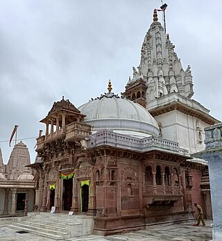
Ujjain or Ujjayinī is a city in Ujjain district of the Indian state of Madhya Pradesh. It is the fifth-largest city in Madhya Pradesh by population and is the administrative centre of Ujjain district and Ujjain division. It is one of the Hindu pilgrimage centres of Sapta Puri famous for the Kumbh Mela (Simhastha) held there every 12 years. The famous temple of Mahakaleshwar Jyotirlinga is located in the center of the city. The city has been one of the most prominent trade and political centres of the Indian Subcontinent from the time of the ancient Mahājanapadas until the British colonisation of India.

Dewas is a city in the Malwa region of the Indian state of Madhya Pradesh. The municipality was formerly the seat of two 15-Gun Salute state princely states during the British Raj, Dewas Junior state and Dewas Senior state, ruled by the Pawar clan of the Marathas. The city is the administrative capital of Dewas district. Dewas is an industrialised city and houses a government bank note press.

Morena is the headquarter of Morena district in the Indian state of Madhya Pradesh. It shares borders with Bhind, Gwalior, Sheopur and Dholpur It is governed by a municipality corporation. It is also the administrative headquarters of the Chambal division. It is 39 kilometres (24 mi) from Gwalior, Madhya Pradesh.
Malvi or Malwi is an Indo-Aryan language spoken in the Malwa region of India. It is a dialect of Rajasthani language.
Kanad is a town and a nagar parishad in Agar Malwa district in the Indian state of Madhya Pradesh. It comes under Kanad Parishad. It belongs to Ujjain Division. It is situated along the Agar–Sarangpur SH-41 highway. It is located 18 km (11 mi) towards east from the district headquarters of Agar Malwa, 83 km (52 mi) from Ujjain, 186 km (116 mi) from the state capital of Bhopal.

Shajapur is a town in Malwa region of Madhya Pradesh state in west-central India. It is the headquarters of Shajapur district.
Maksi is a city and a municipality in Shajapur district in the Indian state of Madhya Pradesh. It is famous for Jain Temple of Maksi Parshwanathh Ji. Maksi has an ever buzzing market which is famous for sweet samosas.
Sarangpur is a city and tehsil in Rajgarh district in the Indian state of Madhya Pradesh. It is situated at the bank of the river Kali Sindh.

The 12919 / 12920 Malwa Express is a Superfast Express train service of the Indian Railways connecting Dr. Ambedkar Nagar of Madhya Pradesh and Shri Mata Vaishno Devi Katra of Jammu and Kashmir. It is currently being operated with 12919/12920 train numbers on a daily basis.
Kalapipal Mandi or Pankhedi is a City in Shajapur district of Madhya Pradesh, India. It is located on Western railways Bhopal - Ujjain section and is connected by railway to some major city's of Madhya Pradesh like Bhopal, Indore and Ujjain. Nearest airport Bhopal.

Hari Joshi is a Hindi writer, satirist, novelist and poet.

Agar Malwa District is a district in the state of Madhya Pradesh in India. It was carved out of Shajapur district. Its administrative headquarters are situated in the town of Agar.
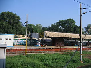
The Gwalior Indore Manmad line is a railway route on the Western Railway, West Central Railway & North Central Railway section of Indian Railways. CRS inspection of RE work of Maksi Ruthiyai and Guna Gwalior has been done in Jul 2020. Now this route is fully electrified from Indore, Dewas, Maksi, Shajapur, Biyavra Rajgarh (BRRG), Ruthiyai, Guna, Shivpuri and Gwalior. This Gwalior, Guna, Ruthiyai, Maksi, Dewas, Indore Single Electrified Rail Line will be a connecting rail line for Indore Manmad Rail Line Project(under Central Railway, Bhusawal Division) and will boost the economical development in Malwa Region of Madhya Pradesh. The Indore Manmad Railway Line project covers 6 Districts in 2 States i.e., Maharashtra and Madhya Pradesh will increase the existing network of Indian Railways by about 309 km.
Sundersi is a town in the Shajapur District of Madhya Pradesh known for its Mahakaleshwar Jyotirlinga temple which mirrors the one in Ujjain.The town is situated at the banks of Kalisindh river.
Piprai is a town and Nagar Panchayat in Ashoknagar District of Madhya Pradesh in India. It is also a Tehsil
Majhauli is a Town and a Nagar Panchayat in Sidhi District of Madhya Pradesh. Its also a Tehsil Headquarter.
Bajag is a Village and a Tehsil headquarter in Dindori District of Madhya Pradesh 481882 is pin Code of Bajag. There is a Government College in Bajag for Education for tribes people. Also a Police Station in village.
Gulana or Golana is a town and Tehsil Headquarter in Shajapur District of Madhya Pradesh. Gulana was an assembly constituency until 2008. It was abolished in 2008.
Mohan Barodia is a Town and a Tehsil Headquarter in Shajapur District of Madhya Pradesh. It's also a Development Block in District. 465226 is Pin Code of Mohan Barodia.


