Madhya Pradesh is a state in central India. Its capital is Bhopal, and its largest city is Indore, with Jabalpur, Gwalior being the other major cities. Madhya Pradesh is the second largest Indian state by area and the fifth largest state by population with over 72 million residents. It borders the states of Uttar Pradesh to the northeast, Chhattisgarh to the east, Maharashtra to the south, Gujarat to the west, and Rajasthan to the northwest.

Khandwa is a city and a nagar nigam in the Nimar region of Madhya Pradesh, India. It is the administrative headquarters of the Khandwa district, formerly known as East Nimar District.
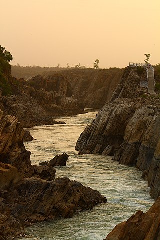
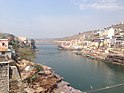
The Narmada River, previously also known as Narbada or anglicised as Nerbudda, is the 5th longest river in India and overall the longest west-flowing river in the country. It is also the largest flowing river in the state of Madhya Pradesh. This river flows through the states of Madhya Pradesh and Gujarat in India. It is also known as the "Lifeline of Madhya Pradesh and Gujarat" due to its huge contribution to the two states in many ways. The Narmada River rises from the Amarkantak Plateau in Anuppur district in Madhya Pradesh. It forms the traditional boundary between North and South India and flows westwards for 1,312 km (815.2 mi) before draining through the Gulf of Khambhat into the Arabian Sea, 30 km (18.6 mi) west of Bharuch city of Gujarat.

Nimar / Nimad is the southwestern region of Madhya Pradesh state in west-central India. This region has sub-regions which include Nimar, Khargone Khandwa Barwani Burhanpur and Dhar.

Barwani or Badwani is a municipal town in Barwani district of Madhya Pradesh, India, that is situated near the left bank of the Narmada River. It is the administrative headquarters of Barwani district and has also served as the capital of the former princely state of Barwani. Barwani is only accessible by road.

Betul district is a district of Madhya Pradesh state in central India. The city of Betul serves as its administrative headquarters. The district is a part of Narmadapuram Division.

The Dewas District is a district in the Indian state of Madhya Pradesh. The town of Dewas is the district headquarters. It belongs to Ujjain Division.

Khargone district, formerly known as West Nimar district, is a district of Madhya Pradesh state in central India. The district lies in the Nimar region and is part of the Indore Division. The district headquarters is the city of Khargone, which lies south of the Indore metropolis, the headquarters of Indore district.

Barwani district is one of the districts of Madhya Pradesh state of India. The administrative headquarters of the district is at Barwani.

Burhanpur District is a district of Madhya Pradesh state in central India. The city of Burhanpur is the district headquarters.

Dhar district is a district of Madhya Pradesh state in central India. The historic town of Dhar is administrative headquarters of the district.

Khargone is a city and administrative headquarters of the Khargone district in the Indian state of Madhya Pradesh. The city is located on the bank of the Kunda river and is known for its cotton and chilly production. It is also known for Navgraha Mandir, a temple devoted to the nav grahas. Khargone topped the nation in municipality and received a national award for 'India's Fastest Moving City' under a population of two lakh. Khargone ranked 10th Cleanest city in India in Swachh Survekshan 2020 City ranked the 15th cleanest city in India in Swachh Survekshan 2018 and ranked 17th cleanest city in India in Swachh Survekshan 2017.
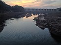
The Indira Sagar Dam is the largest dam in India, in terms of volume of water stored in the reservoir. It is located on the Narmada River at the town of Narmada Nagar, Punasa in the Khandwa district of Madhya Pradesh in India. The foundation stone of the project was laid by the prime minister of India Indira Gandhi on 23 October 1984. The construction of the main dam started in 1992. The downstream projects of ISP are Omkareshwar, Maheshwar, and Sardar Sarovar Project. To build it, a town of 22,000 people and 100 villages was displaced.

Barwaha is a municipality and sub district in Khargone district in the state of Madhya Pradesh, India situated on the banks of Narmada river. Barwaha is second biggest city of District after Khargone city. The Barwaha city is divided into 28 wards for which elections are held every 5 years. The Barwaha Municipality has population of 61,973 of which 32,940 are males while 29,033 are females as per report released by Census India 2011. Literacy rate of Barwaha is 87.27% higher than state average of 69.32%. The male and female literacy rate is around 92.73% and 81.23%.

Mundi is a city and Tehsil in the Khandwa district of Nimar region the Indian state of Madhya Pradesh. It is situated in North Side of East Nimar District.

Sanawad is an Indian town and Municipality in Khargone district in the Indian state of Madhya Pradesh. It is a popular center for the trade of cotton and wheat. Nearby cities include Khargone, Khandwa, Barwaha and Indore.
Nimadi is a Western Indo-Aryan language spoken in the Nimar region of west-central India within the state of Madhya Pradesh. This region lies adjacent to Maharashtra and south of Malwa. The districts where Nimadi is spoken are: Barwani, Khandwa, Barwaha, Khargone, Burhanpur, Sanawad and southern most parts of Dhar, Harda and Dewas districts. This language is classified as a dialect of Rajasthani language. The famous writers of Nimari were Gaurishankar Sharma, Ramnarayan Upadhyay, Surendra Khede, etc.

The Nerbudda Division, named after the Narmada River (Nerbudda), was a former administrative division of the Central Provinces of British India. It encompassed a good part of the Narmada River basin in the eastern part of present-day Madhya Pradesh state of India. The Nerbudda Division had an area of 47,609.2 km2 with a population of 1,785,008 in 1901.
Narmada Expressway is a proposed eight-lane expressway in the state of Madhya Pradesh. The proposed expressway will connect the historic towns of Amarkantak in the eastern end of Madhya Pradesh via Dindori, Shahpura, Jabalpur, Narmadapuram, Barwaha and Alirajpur in the western end of Madhya Pradesh alongside the Narmada River. The expressway measures 1,300 km. It will connect Gujarat with Chhattisgarh. Later, this road will be extended to connect Alirajpur to Ahmedabad.
Khalwa is a town and a Tehsil Headquarter in Khandwa District of Madhya Pradesh. Khalwa is a tribal dominated area of Madhya Pradesh. Khalwa is located 50 km away from Khandwa on the bank of a manjri named small river.